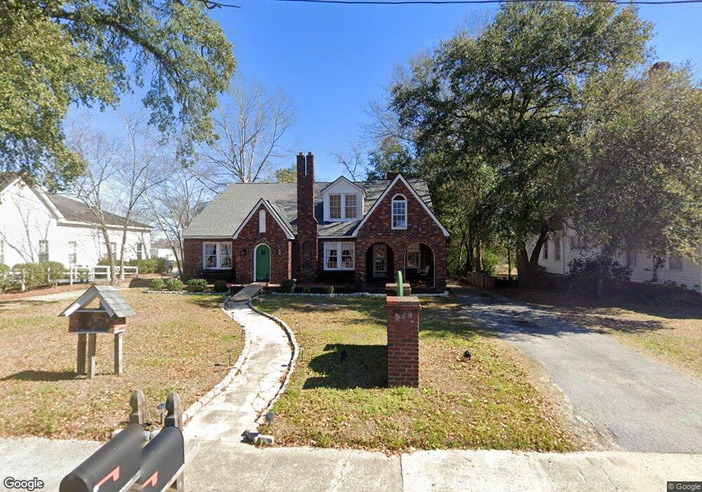
142 N Main St Statesboro, GA 30458
Estimated Value: $320,000 - $367,934
7
Beds
5
Baths
3,501
Sq Ft
$97/Sq Ft
Est. Value
About This Home
This home is located at 142 N Main St, Statesboro, GA 30458 and is currently estimated at $339,234, approximately $96 per square foot. 142 N Main St is a home located in Bulloch County with nearby schools including Mattie Lively Elementary School, Statesboro High School, and William James Middle School.
Ownership History
Date
Name
Owned For
Owner Type
Purchase Details
Closed on
Jun 1, 2020
Sold by
Holloway Strickland
Bought by
Wright Trevor Cole and Wright Harold Dean
Current Estimated Value
Home Financials for this Owner
Home Financials are based on the most recent Mortgage that was taken out on this home.
Original Mortgage
$175,750
Outstanding Balance
$155,789
Interest Rate
3.2%
Mortgage Type
New Conventional
Estimated Equity
$183,445
Purchase Details
Closed on
May 3, 2004
Bought by
Holloway Strickland
Create a Home Valuation Report for This Property
The Home Valuation Report is an in-depth analysis detailing your home's value as well as a comparison with similar homes in the area
Home Values in the Area
Average Home Value in this Area
Purchase History
| Date | Buyer | Sale Price | Title Company |
|---|---|---|---|
| Wright Trevor Cole | $185,000 | -- | |
| Holloway Strickland | -- | -- |
Source: Public Records
Mortgage History
| Date | Status | Borrower | Loan Amount |
|---|---|---|---|
| Open | Wright Trevor Cole | $175,750 |
Source: Public Records
Tax History Compared to Growth
Tax History
| Year | Tax Paid | Tax Assessment Tax Assessment Total Assessment is a certain percentage of the fair market value that is determined by local assessors to be the total taxable value of land and additions on the property. | Land | Improvement |
|---|---|---|---|---|
| 2024 | $3,529 | $128,760 | $20,000 | $108,760 |
| 2023 | $3,038 | $106,080 | $21,040 | $85,040 |
| 2022 | $1,845 | $94,088 | $21,040 | $73,048 |
| 2021 | $1,492 | $82,984 | $21,040 | $61,944 |
| 2020 | $1,172 | $56,486 | $21,040 | $35,446 |
| 2019 | $1,172 | $56,132 | $21,040 | $35,092 |
| 2018 | $1,259 | $57,827 | $21,040 | $36,787 |
| 2017 | $1,231 | $55,911 | $21,040 | $34,871 |
| 2016 | $1,229 | $54,378 | $21,040 | $33,338 |
| 2015 | $1,190 | $52,462 | $21,040 | $31,422 |
| 2014 | $1,093 | $52,462 | $21,040 | $31,422 |
Source: Public Records
Map
Nearby Homes
- 0 Oak St Unit OAK ST/ LOT 2
- 118 Roundtree St
- 17 E Parrish St
- 0 Highway 67 Unit 10541885
- 318 N Main St
- 7 E Moore St
- 11 W Moore St
- 6.24 ACRES E Olliff St
- 118 Pin Oak Ln Unit 47
- 328 N Main St
- LOT 21 Oak Hill Dr
- 9 Broad St
- 103 Floyd St
- 405 N Main St
- 316 E Main St
- 0 W Inman St Unit 10636708
- 15 S Foss St
- 0 Miller Street Extension Unit LOT 19
- 0 Miller Street Extension Unit LOT 17
- 0 Miller Street Extension Unit LOT 23 10594167
- 144 N Main St
- 134 N Main St
- 127 N Main St
- 127 N Main St Unit SUITE 208
- 127 N Main St Unit DOWNSTAIRS
- 7 E Olliff St
- 14 E Olliff St
- 1 Northside Dr E
- 7 Woodrow Ave
- 7 Church St
- 16 E Olliff St
- E U S 80 Unit 1-A
- E U S 80 Unit 3-B
- E U S 80 Unit 1-B
- E U S 80 Unit 3-A
- E U S 80
- 0 N Main St Unit 7457109
- 0 N Main St Unit 7051381
- 0 N Main St Unit 8642387
- 0 N Main St Unit 8253070