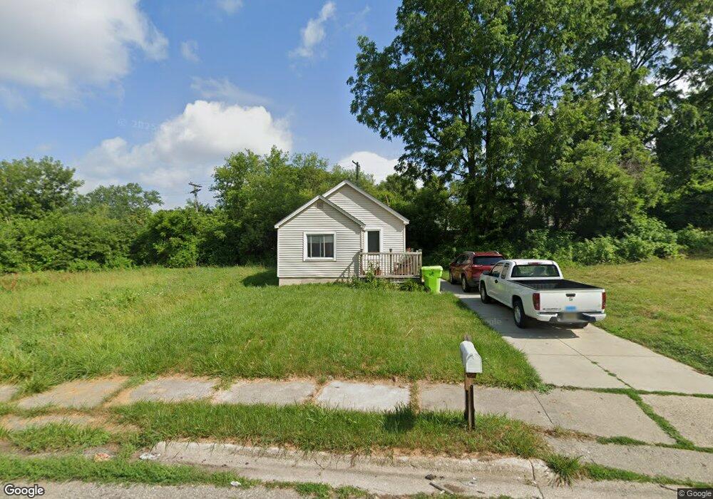
142 N Merrimac St Pontiac, MI 48340
Estimated Value: $104,171 - $132,000
2
Beds
1
Bath
1,059
Sq Ft
$113/Sq Ft
Est. Value
About This Home
This home is located at 142 N Merrimac St, Pontiac, MI 48340 and is currently estimated at $119,293, approximately $112 per square foot. 142 N Merrimac St is a home located in Oakland County with nearby schools including Alcott School, Pontiac Middle School, and Pontiac High School.
Ownership History
Date
Name
Owned For
Owner Type
Purchase Details
Closed on
Jan 31, 2011
Sold by
Kalaj Peter and F & P Painting Inc
Bought by
Sula Xhemal
Current Estimated Value
Purchase Details
Closed on
Oct 18, 2008
Sold by
Kalaj Peter
Bought by
F & P Painting Inc
Purchase Details
Closed on
Dec 14, 2006
Sold by
Deutsche Bank National Trust Co
Bought by
Kalaj Peter
Purchase Details
Closed on
Dec 1, 2006
Sold by
Deutsche Bank National Trust Co
Bought by
Homesales Inc
Purchase Details
Closed on
Apr 25, 2006
Sold by
London Frederick C and London Nancy A
Bought by
Deutsche Bank National Trust Co and Bankers Trust Co Of California Na
Create a Home Valuation Report for This Property
The Home Valuation Report is an in-depth analysis detailing your home's value as well as a comparison with similar homes in the area
Home Values in the Area
Average Home Value in this Area
Purchase History
| Date | Buyer | Sale Price | Title Company |
|---|---|---|---|
| Sula Xhemal | -- | None Available | |
| F & P Painting Inc | -- | None Available | |
| Kalaj Peter | $6,500 | First American Title | |
| Homesales Inc | -- | None Available | |
| Deutsche Bank National Trust Co | $15,600 | None Available |
Source: Public Records
Tax History Compared to Growth
Tax History
| Year | Tax Paid | Tax Assessment Tax Assessment Total Assessment is a certain percentage of the fair market value that is determined by local assessors to be the total taxable value of land and additions on the property. | Land | Improvement |
|---|---|---|---|---|
| 2024 | $685 | $32,330 | $0 | $0 |
| 2023 | $653 | $28,670 | $0 | $0 |
| 2022 | $693 | $25,160 | $0 | $0 |
| 2021 | $611 | $21,260 | $0 | $0 |
| 2020 | $594 | $19,140 | $0 | $0 |
| 2019 | $603 | $16,590 | $0 | $0 |
| 2018 | $591 | $13,970 | $0 | $0 |
| 2017 | $563 | $13,070 | $0 | $0 |
| 2016 | $559 | $10,700 | $0 | $0 |
| 2015 | -- | $10,330 | $0 | $0 |
| 2014 | -- | $9,960 | $0 | $0 |
| 2011 | -- | $13,530 | $0 | $0 |
Source: Public Records
Map
Nearby Homes
- 201 Parkdale Ave
- 119 W Kennett Rd
- 109 W Kennett Rd
- 32 N Merrimac St
- 998 Dewey St
- 33 W Beverly Ave
- 743 Hollister St
- 0000 Blaine Ave
- 686 Lounsbury Ave
- 255 W Rutgers Ave
- 89 W Fairmount Ave
- 54 Hudson Ave
- 18 E Rutgers Ave
- 134 W Fairmount Ave
- 1017 Cherrylawn Dr
- 117 W Strathmore Ave
- 240 W Fairmount Ave
- 207 W Strathmore Ave
- 112 W Strathmore Ave
- 841 Orlando Ave
- 142 N Merrimac St
- 144 N Merrimac St
- 148 N Merrimac St
- 145 Parkdale Ave
- 152 N Merrimac St
- 145 N Merrimac St
- 137 Parkdale Ave
- 156 N Merrimac St
- 842 Terry Ave
- 846 Terry Ave
- 850 Terry Ave
- 133 Parkdale Ave
- 160 N Merrimac St
- 133 N Merrimac St
- 129 Parkdale Ave
- 146 S Merrimac St
- 142 S Merrimac St
- 125 Parkdale Ave
- S Merrimac
- 129 N Merrimac St