
Seller's Agent in 2025
Leah Hart
Coldwell Banker Realty - Weston
(508) 277-9978
19 in this area
46 Total Sales
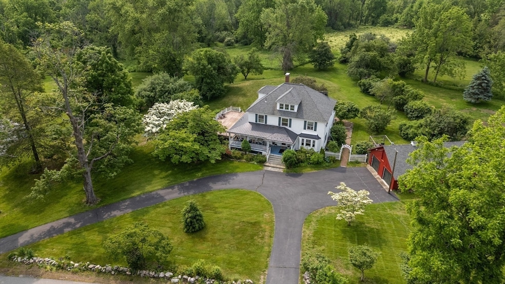
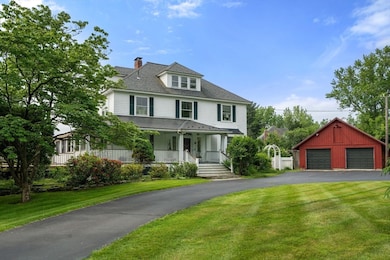
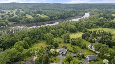
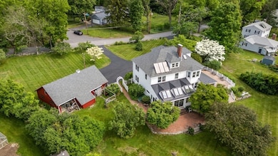
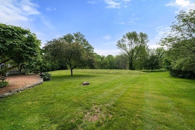
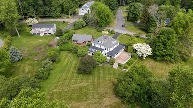
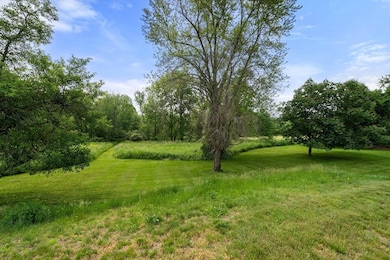
Nature lover's dream property in Wayland! Sited on over an acre with direct access to miles of protected land and the scenic Sudbury River this home offers nature's beauty up close. Classic 1910 Colonial with inviting farmer’s porch boasts 3 bedrooms, 2.5 baths and 3000 sq ft on lushly landscaped grounds. Idyllic red barn garage for two-cars, a workshop and storage. The gracious foyer with 8’ 4’’ ceilings and original hardwood floors sets the tone. Spectacular year-round sunroom with sliders and skylights offer breathtaking views and southern exposure. Large living room with fireplace, and expansive deck and brick patio for relaxation. Charming dining room to entertain. Spacious eat-in kitchen and half bath complete the first floor. Upstairs, the main bedroom features an ensuite bathroom, laundry, and two additional bedrooms and full bath. The 3rd level is ideal for crafts and games. Updates: roof, 4-bedroom septic, efficient gas heating, and electric panel. An unparalleled location!
| Date | Type | Sale Price | Title Company |
|---|---|---|---|
| Quit Claim Deed | -- | None Available | |
| Quit Claim Deed | -- | None Available | |
| Quit Claim Deed | -- | None Available | |
| Deed | -- | -- |
| Date | Status | Loan Amount | Loan Type |
|---|---|---|---|
| Previous Owner | $200,000 | No Value Available |
| Date | Event | Price | List to Sale | Price per Sq Ft |
|---|---|---|---|---|
| 11/07/2025 11/07/25 | Sold | $1,175,000 | +2.2% | $369 / Sq Ft |
| 10/14/2025 10/14/25 | Pending | -- | -- | -- |
| 10/08/2025 10/08/25 | For Sale | $1,150,000 | -- | $361 / Sq Ft |
| Year | Tax Paid | Tax Assessment Tax Assessment Total Assessment is a certain percentage of the fair market value that is determined by local assessors to be the total taxable value of land and additions on the property. | Land | Improvement |
|---|---|---|---|---|
| 2025 | $17,173 | $1,098,700 | $558,000 | $540,700 |
| 2024 | $16,277 | $1,048,800 | $531,600 | $517,200 |
| 2023 | $15,528 | $932,600 | $483,200 | $449,400 |
| 2022 | $15,394 | $838,900 | $400,000 | $438,900 |
| 2021 | $14,814 | $799,900 | $363,600 | $436,300 |
| 2020 | $13,975 | $786,900 | $363,600 | $423,300 |
| 2019 | $14,125 | $772,700 | $346,400 | $426,300 |
| 2018 | $12,742 | $706,700 | $346,400 | $360,300 |
| 2017 | $12,248 | $675,200 | $330,000 | $345,200 |
| 2016 | $11,510 | $663,800 | $323,600 | $340,200 |
Seller's Agent in 2025
Leah Hart
Coldwell Banker Realty - Weston
(508) 277-9978
19 in this area
46 Total Sales
Buyer's Agent in 2025
Saad Munir
Torii, Inc.
(781) 296-6446
3 in this area
135 Total Sales
Source: MLS Property Information Network (MLS PIN)
MLS Number: 73441331
APN: WAYL-000028-000000-000021
Disclaimer: Certain information contained herein is derived from information provided by parties other than Homes.com. All information provided is deemed reliable, but is not guaranteed to be accurate and should be independently verified.
![]() The property listing data and information, or the Images, set forth herein were provided to MLS Property Information Network, Inc. from third party sources, including sellers, lessors and public records, and were compiled by MLS Property Information Network, Inc. The property listing data and information, and the Images, are for the personal, non-commercial use of consumers having a good faith interest in purchasing or leasing listed properties of the type displayed to them and may not be used for any purpose other than to identify prospective properties which such consumers may have a good faith interest in purchasing or leasing. MLS Property Information Network, Inc. and its subscribers disclaim any and all representations and warranties as to the accuracy of the property listing data and information, or as to the accuracy of any of the Images, set forth herein.
The property listing data and information, or the Images, set forth herein were provided to MLS Property Information Network, Inc. from third party sources, including sellers, lessors and public records, and were compiled by MLS Property Information Network, Inc. The property listing data and information, and the Images, are for the personal, non-commercial use of consumers having a good faith interest in purchasing or leasing listed properties of the type displayed to them and may not be used for any purpose other than to identify prospective properties which such consumers may have a good faith interest in purchasing or leasing. MLS Property Information Network, Inc. and its subscribers disclaim any and all representations and warranties as to the accuracy of the property listing data and information, or as to the accuracy of any of the Images, set forth herein.