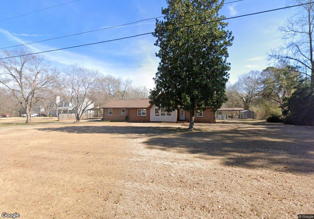
142 S Tamie Cir Kathleen, GA 31047
Estimated Value: $272,000 - $308,108
3
Beds
2
Baths
1,651
Sq Ft
$173/Sq Ft
Est. Value
About This Home
This home is located at 142 S Tamie Cir, Kathleen, GA 31047 and is currently estimated at $286,277, approximately $173 per square foot. 142 S Tamie Cir is a home located in Houston County with nearby schools including Hilltop Elementary School, Bonaire Middle School, and Veterans High School.
Ownership History
Date
Name
Owned For
Owner Type
Purchase Details
Closed on
Dec 28, 2001
Sold by
Daughtry Robert L and Daughtry Susan C
Bought by
Greene Clifford H and Dana H*
Current Estimated Value
Purchase Details
Closed on
Apr 6, 2000
Sold by
Spratling Robert K
Bought by
Daughtry Robert L and Susan C*
Purchase Details
Closed on
Jul 1, 1987
Sold by
Spratling Robert K and Spratling Charlotte
Bought by
Spratling Robert K
Purchase Details
Closed on
Apr 8, 1969
Sold by
Webster Norman R and Webster Mary L
Bought by
Spratling Robert K and Spratling Charlotte R
Create a Home Valuation Report for This Property
The Home Valuation Report is an in-depth analysis detailing your home's value as well as a comparison with similar homes in the area
Home Values in the Area
Average Home Value in this Area
Purchase History
| Date | Buyer | Sale Price | Title Company |
|---|---|---|---|
| Greene Clifford H | $120,000 | -- | |
| Daughtry Robert L | -- | -- | |
| Spratling Robert K | -- | -- | |
| Spratling Robert K | -- | -- |
Source: Public Records
Tax History Compared to Growth
Tax History
| Year | Tax Paid | Tax Assessment Tax Assessment Total Assessment is a certain percentage of the fair market value that is determined by local assessors to be the total taxable value of land and additions on the property. | Land | Improvement |
|---|---|---|---|---|
| 2024 | $2,217 | $94,700 | $27,680 | $67,020 |
| 2023 | $1,875 | $79,564 | $26,880 | $52,684 |
| 2022 | $1,869 | $79,324 | $26,880 | $52,444 |
| 2021 | $1,573 | $66,760 | $21,840 | $44,920 |
| 2020 | $1,339 | $56,840 | $16,440 | $40,400 |
| 2019 | $1,339 | $56,840 | $16,440 | $40,400 |
| 2018 | $1,339 | $56,840 | $16,440 | $40,400 |
| 2017 | $1,340 | $56,840 | $16,440 | $40,400 |
| 2016 | $1,261 | $53,520 | $16,440 | $37,080 |
| 2015 | $1,263 | $53,520 | $16,440 | $37,080 |
| 2014 | -- | $53,520 | $16,440 | $37,080 |
| 2013 | -- | $53,520 | $16,440 | $37,080 |
Source: Public Records
Map
Nearby Homes
- 119 Richfield Cir
- 231 Grove Ln
- 135 Pond Dr
- 101 Pond Dr
- 105 Cabin Cove Dr
- 410 Woodlands Blvd
- 2006 Melrose Place
- 510 Mt Zion Rd
- 510 Mount Zion Rd
- 204 Weeping Moss Way
- 210 Kenna Way
- 527 Bristleleaf Path
- 117 Black Birch Ln
- 115 Black Birch Ln
- 102 Emberwood Dr
- 200 Emberwood Way
- 102 Emberwood Way
- 206 Emberwood Way
- 109 Harley Dr
- 146 S Tamie Cir
- 105 Tamie Ct Unit 71
- 105 Tamie Ct
- 105 Tamie Ct Unit 18
- 125 S Tamie Cir
- 127 S Tamie Cir
- 123 S Tamie Cir
- 148 S Tamie Cir
- 129 S Tamie Cir
- 104 Tamie Ct
- 104 Tamie Ct Unit 72
- 153 N Tamie Cir
- 134 S Tamie Cir
- 100 Tamie Ct
- 100 Tamie Ct Unit 134
- 132 S Tamie Cir
- 121 S Tamie Cir
- 130 S Tamie Cir
- 126 N Tamie Cir
- 151 N Tamie Cir