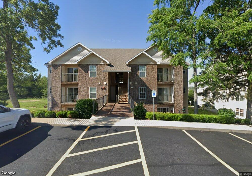
142 Vixen Cir Unit D Branson, MO 65616
North Branson NeighborhoodEstimated Value: $162,000 - $173,000
2
Beds
2
Baths
1,025
Sq Ft
$162/Sq Ft
Est. Value
About This Home
This home is located at 142 Vixen Cir Unit D, Branson, MO 65616 and is currently estimated at $165,820, approximately $161 per square foot. 142 Vixen Cir Unit D is a home located in Taney County with nearby schools including Cedar Ridge Primary, Cedar Ridge Intermediate School, and Cedar Ridge Elementary School.
Ownership History
Date
Name
Owned For
Owner Type
Purchase Details
Closed on
Oct 7, 2020
Sold by
Graff Loren L and Graff Kristen R
Bought by
Plan B Today Inc
Current Estimated Value
Purchase Details
Closed on
May 1, 2018
Sold by
Graff Loren L and Graff Kristen R
Bought by
Graff Kristen R and Graff Loren L
Purchase Details
Closed on
Mar 16, 2015
Sold by
K & L Investments Llc
Bought by
Graff Loren L and Graff Kristen R
Purchase Details
Closed on
Aug 22, 2012
Sold by
Combs Arthur G
Bought by
K & L Investments Llc and Graff Loren L
Home Financials for this Owner
Home Financials are based on the most recent Mortgage that was taken out on this home.
Original Mortgage
$72,000
Interest Rate
3.49%
Mortgage Type
Future Advance Clause Open End Mortgage
Create a Home Valuation Report for This Property
The Home Valuation Report is an in-depth analysis detailing your home's value as well as a comparison with similar homes in the area
Home Values in the Area
Average Home Value in this Area
Purchase History
| Date | Buyer | Sale Price | Title Company |
|---|---|---|---|
| Plan B Today Inc | -- | None Available | |
| Graff Kristen R | -- | None Available | |
| Graff Loren L | -- | Tri Lakes Title Company | |
| K & L Investments Llc | -- | Hogan Land Title |
Source: Public Records
Mortgage History
| Date | Status | Borrower | Loan Amount |
|---|---|---|---|
| Previous Owner | K & L Investments Llc | $72,000 |
Source: Public Records
Tax History
| Year | Tax Paid | Tax Assessment Tax Assessment Total Assessment is a certain percentage of the fair market value that is determined by local assessors to be the total taxable value of land and additions on the property. | Land | Improvement |
|---|---|---|---|---|
| 2025 | $718 | $14,230 | -- | -- |
| 2024 | $718 | $13,420 | -- | -- |
| 2023 | $718 | $13,420 | $0 | $0 |
| 2022 | $698 | $13,420 | $0 | $0 |
| 2021 | $693 | $13,420 | $0 | $0 |
| 2019 | $644 | $11,950 | $0 | $0 |
| 2018 | $645 | $11,950 | $0 | $0 |
| 2017 | $657 | $12,300 | $0 | $0 |
| 2016 | $656 | $12,300 | $0 | $0 |
| 2015 | $649 | $12,300 | $0 | $0 |
| 2014 | $791 | $15,700 | $0 | $0 |
Source: Public Records
Map
Nearby Homes
- 134 Vixen Cir Unit G
- 118 Vixen Cir Unit D
- 160 Brookside Ct
- 128 Stillwood Dr
- 142 Rue de Villas Cir
- 210 Rue de Villas Cir
- 328 Sunny Brook Dr
- 121 Rue de Villas Cir
- 118 Rue de Villas Cir
- 229 Stillwood Dr Unit 6a
- 160 Rue de Villas Cir
- 125 Lakehills Dr Unit B
- 301 Stillwood Dr
- 311 Stillwood Dr
- 153 Sapling Dr
- 464 State Highway 248
- 154 Sapling Dr
- 2800 Gretna
- 000000 Ozark Scenic Dr
- Lot 96 Stone Valley Estates
- 142 Vixen Cir Unit I
- 142 Vixen Cir
- 142 Vixen Cir Unit K
- 142 Vixen Cir Unit F
- 142 Vixen Cir Unit B
- 142 Vixen Cir Unit J
- 142 Vixen Cir Unit E
- 142 Vixen Cir Unit A
- 142 Vixen Cir Unit C
- 142 Vixen Cir Unit G
- 142 Vixen Circle I Unit I
- 134 Vixen Circle # D Unit D
- 134 Vixen Cir Unit I Bldg 134
- 134 Vixen Cir
- 134 Vixen Cir
- 134 Vixen Cir Unit H
- 134 Vixen Cir Unit G
- 134 Vixen Cir Unit C
- 134 Vixen Cir Unit A
- 134 Vixen Cir Unit E
Your Personal Tour Guide
Ask me questions while you tour the home.