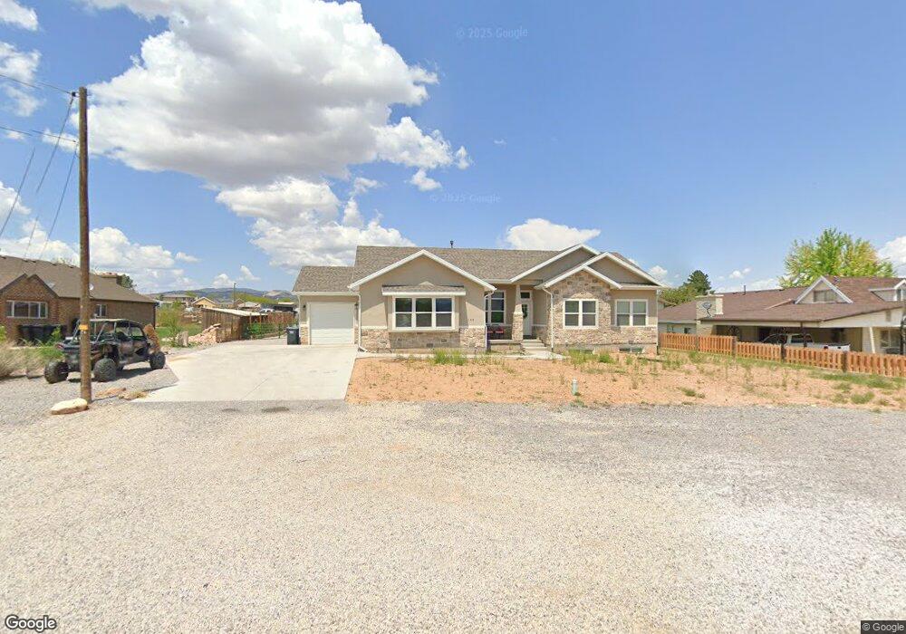
142 W 100 N Aurora, UT 84620
Estimated Value: $421,000 - $529,664
--
Bed
--
Bath
1,726
Sq Ft
$266/Sq Ft
Est. Value
About This Home
This home is located at 142 W 100 N, Aurora, UT 84620 and is currently estimated at $458,416, approximately $265 per square foot. 142 W 100 N is a home with nearby schools including Salina School, North Sevier Middle School, and North Sevier High School.
Ownership History
Date
Name
Owned For
Owner Type
Purchase Details
Closed on
Jan 10, 2020
Sold by
Shaw Kent and Shaw Angie
Bought by
Shaw Kent and Shaw Angela
Current Estimated Value
Home Financials for this Owner
Home Financials are based on the most recent Mortgage that was taken out on this home.
Original Mortgage
$301,000
Outstanding Balance
$266,457
Interest Rate
3.7%
Mortgage Type
New Conventional
Estimated Equity
$191,959
Purchase Details
Closed on
May 7, 2019
Sold by
Burgoyne V Carolyn S
Bought by
Shaw Kent and Shaw Angie
Purchase Details
Closed on
Feb 2, 2018
Sold by
Burgoyne Carolyn S
Bought by
Burgoyne Carolyn S and The V Carolyn S Burgoyne Trust
Create a Home Valuation Report for This Property
The Home Valuation Report is an in-depth analysis detailing your home's value as well as a comparison with similar homes in the area
Home Values in the Area
Average Home Value in this Area
Purchase History
| Date | Buyer | Sale Price | Title Company |
|---|---|---|---|
| Shaw Kent | -- | First American Title Ins Co | |
| Shaw Kent | -- | Backman Title Services Ltd | |
| Burgoyne Carolyn S | -- | None Available |
Source: Public Records
Mortgage History
| Date | Status | Borrower | Loan Amount |
|---|---|---|---|
| Open | Shaw Kent | $301,000 |
Source: Public Records
Tax History Compared to Growth
Tax History
| Year | Tax Paid | Tax Assessment Tax Assessment Total Assessment is a certain percentage of the fair market value that is determined by local assessors to be the total taxable value of land and additions on the property. | Land | Improvement |
|---|---|---|---|---|
| 2024 | $2,336 | $277,747 | $32,985 | $244,762 |
| 2023 | $2,463 | $287,123 | $30,740 | $256,383 |
| 2022 | $2,259 | $226,678 | $27,394 | $199,284 |
| 2021 | $2,498 | $208,214 | $18,336 | $189,878 |
| 2020 | $2,332 | $182,638 | $17,463 | $165,175 |
| 2019 | $317 | $26,510 | $26,510 | $0 |
| 2018 | $290 | $21,570 | $21,570 | $0 |
| 2017 | $304 | $21,570 | $21,570 | $0 |
| 2016 | -- | $21,570 | $0 | $0 |
| 2015 | -- | $21,570 | $0 | $0 |
| 2014 | -- | $21,570 | $0 | $0 |
Source: Public Records
Map
Nearby Homes
- 70 N Main
- 770 N 300 W Unit 102
- 675 N 300 W Unit 111
- 695 N 300 W Unit 112
- 725 N 300 W Unit 113
- 750 N 300 W Unit 101
- 390 N 300 W
- 122 S 500 W
- 330 W 800 S Unit 105
- 680 E 300 S Unit 110
- 310 W 800 S Unit 106
- 2200 N Hwy 260 (Approximately) W
- 2203 S 1770 W Unit 1
- 79 S 250 E
- 305 E 2690 N
- 2220 N State St Unit 14
- Tbd S State St Unit LotWP001
- 375 W Sandy Ln
- 325 Cobble St
- 630 W 285 N