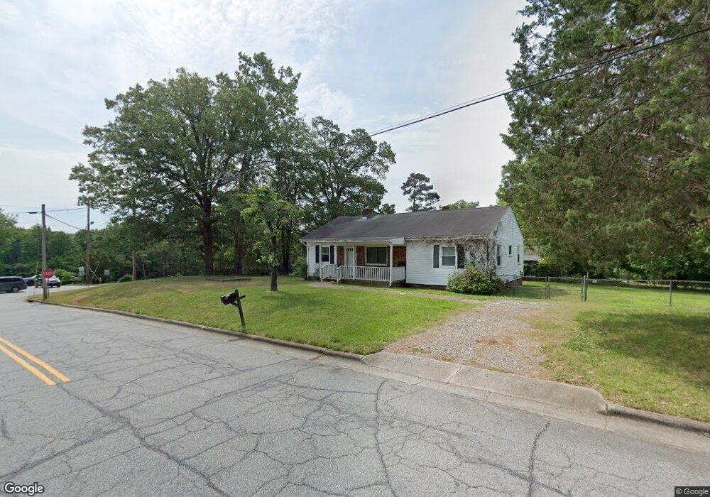
1420 Bragg Ave High Point, NC 27265
Greater High Point NeighborhoodEstimated Value: $171,218 - $215,000
3
Beds
1
Bath
1,524
Sq Ft
$126/Sq Ft
Est. Value
About This Home
This home is located at 1420 Bragg Ave, High Point, NC 27265 and is currently estimated at $192,305, approximately $126 per square foot. 1420 Bragg Ave is a home located in Guilford County with nearby schools including Montlieu Academy of Technology, Welborn Academy of Science & Technology, and T.W. Andrews High School.
Ownership History
Date
Name
Owned For
Owner Type
Purchase Details
Closed on
Apr 2, 2008
Sold by
Wilson Ronda and Wilson Bobby Eugene
Bought by
City Of High Point
Current Estimated Value
Purchase Details
Closed on
Oct 9, 2000
Sold by
Household Finance Corp
Bought by
Carney Ronda K
Home Financials for this Owner
Home Financials are based on the most recent Mortgage that was taken out on this home.
Original Mortgage
$54,550
Interest Rate
7.96%
Mortgage Type
FHA
Create a Home Valuation Report for This Property
The Home Valuation Report is an in-depth analysis detailing your home's value as well as a comparison with similar homes in the area
Home Values in the Area
Average Home Value in this Area
Purchase History
We collect this data history from publicly available records. To have your information removed, we recommend requesting removal directly through your county’s website.
| Date | Buyer | Sale Price | Title Company |
|---|---|---|---|
| City Of High Point | $97,500 | None Available | |
| Carney Ronda K | $55,000 | -- |
Source: Public Records
Mortgage History
We collect this data history from publicly available records. To have your information removed, we recommend requesting removal directly through your county’s website.
| Date | Status | Borrower | Loan Amount |
|---|---|---|---|
| Previous Owner | Carney Ronda K | $54,550 |
Source: Public Records
Tax History
| Year | Tax Paid | Tax Assessment Tax Assessment Total Assessment is a certain percentage of the fair market value that is determined by local assessors to be the total taxable value of land and additions on the property. | Land | Improvement |
|---|---|---|---|---|
| 2025 | -- | $66,700 | $18,000 | $48,700 |
| 2024 | -- | $66,700 | $18,000 | $48,700 |
| 2023 | -- | $66,700 | $18,000 | $48,700 |
| 2022 | $0 | $66,700 | $18,000 | $48,700 |
| 2021 | $0 | $47,700 | $15,000 | $32,700 |
| 2020 | $0 | $47,700 | $15,000 | $32,700 |
| 2019 | $0 | $0 | $0 | $0 |
| 2018 | $0 | $0 | $0 | $0 |
| 2017 | -- | $0 | $0 | $0 |
| 2016 | -- | $0 | $0 | $0 |
| 2015 | -- | $0 | $0 | $0 |
| 2014 | -- | $0 | $0 | $0 |
Source: Public Records
Map
Nearby Homes
- 1412 Bragg Ave
- 1415 Wiltshire St
- 1445 Bailey Cir
- 1604 E Lexington Ave
- 1509 & 1511 Wiltshire St
- 1410 Wiltshire St
- 2009 Mcguinn Dr
- 1719 Carolina St
- 1808 Guyer St
- 1907 Boulding Ave
- 1515 Ann Arbor Ave
- 1014 Montlieu Ave
- 1012 Meadowbrook Blvd
- 1108 Dartmouth Ave
- 1101 Forrest St
- 1015 Tabor St
- 1103 Wayside St
- 1308 Boundary Ave
- 1508 Boundary Ave
- 801 E Lexington Ave
Your Personal Tour Guide
Ask me questions while you tour the home.