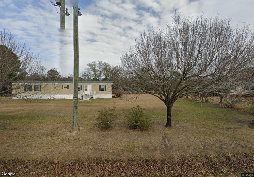
1420 Highway 548 Conway, SC 29527
Estimated Value: $540,000 - $680,588
3
Beds
3
Baths
3,392
Sq Ft
$179/Sq Ft
Est. Value
About This Home
This home is located at 1420 Highway 548, Conway, SC 29527 and is currently estimated at $607,647, approximately $179 per square foot. 1420 Highway 548 is a home located in Horry County with nearby schools including Pee Dee Elementary School, Whittemore Park Middle School, and Conway High School.
Ownership History
Date
Name
Owned For
Owner Type
Purchase Details
Closed on
Dec 23, 2009
Sold by
Resmae Mortgage Corporation
Bought by
Troxell Timothy S
Current Estimated Value
Purchase Details
Closed on
Oct 5, 2009
Sold by
Master In Equity Horry County
Bought by
Resmae Mortgage Corporation
Purchase Details
Closed on
Mar 14, 2007
Sold by
Barnhill Thomas A and Barnhill Elizabeth B
Bought by
Floyd Michael L and Floyd Tina J
Home Financials for this Owner
Home Financials are based on the most recent Mortgage that was taken out on this home.
Original Mortgage
$324,000
Interest Rate
8.83%
Mortgage Type
Purchase Money Mortgage
Purchase Details
Closed on
Jul 20, 1999
Sold by
Lewis Douglas D and Lewis Susan J
Bought by
Barnhill Thomas A and Barnhill Elizabeth B
Create a Home Valuation Report for This Property
The Home Valuation Report is an in-depth analysis detailing your home's value as well as a comparison with similar homes in the area
Home Values in the Area
Average Home Value in this Area
Purchase History
| Date | Buyer | Sale Price | Title Company |
|---|---|---|---|
| Troxell Timothy S | $265,000 | -- | |
| Resmae Mortgage Corporation | $2,500 | -- | |
| Floyd Michael L | $360,000 | None Available | |
| Barnhill Thomas A | $24,000 | -- |
Source: Public Records
Mortgage History
| Date | Status | Borrower | Loan Amount |
|---|---|---|---|
| Previous Owner | Floyd Michael L | $324,000 |
Source: Public Records
Tax History Compared to Growth
Tax History
| Year | Tax Paid | Tax Assessment Tax Assessment Total Assessment is a certain percentage of the fair market value that is determined by local assessors to be the total taxable value of land and additions on the property. | Land | Improvement |
|---|---|---|---|---|
| 2024 | $1,437 | $23,861 | $3,000 | $20,861 |
| 2023 | $1,437 | $12,746 | $883 | $11,863 |
| 2021 | $1,296 | $17,388 | $1,380 | $16,008 |
| 2020 | $1,154 | $17,388 | $1,380 | $16,008 |
| 2019 | $1,025 | $15,912 | $1,380 | $14,532 |
| 2018 | $922 | $9,800 | $768 | $9,032 |
| 2017 | $907 | $9,800 | $768 | $9,032 |
| 2016 | -- | $9,800 | $768 | $9,032 |
| 2015 | $896 | $9,672 | $768 | $8,904 |
| 2014 | $826 | $9,672 | $768 | $8,904 |
Source: Public Records
Map
Nearby Homes
- 3824 Wayside Rd
- 3708 Faith Dr
- 873 Rivas Ct
- 872 Rivas Ct
- 1000 Kinness Dr
- 100 Pepe Ct
- 101 Pepe Ct
- 1013 Kinness Dr
- TBD 2 Highway 548
- 16 Cape Point Dr
- 939 Grace Dr Unit Faith Hills
- 1021 Kinness Dr
- 40 Cape Point Dr
- 1052 Kinness Dr
- 1024 Kinness Dr
- Vision Plan at Rivertown Landing
- Prelude Plan at Rivertown Landing
- Embark Plan at Rivertown Landing
- Vantage Plan at Rivertown Landing
- Venture Plan at Rivertown Landing
- 1505 Highway 548
- 1380 Highway 548
- 1535 Highway 548 Unit Lot 5
- 1535 Highway 548
- 1540 Highway 548
- 1539 Highway 548
- 1539 Highway 548 Unit Oak II plan - lot 4
- 1539 Highway 548 Unit Lot 4
- 1543 Highway 548
- 1543 Highway 548 Unit Lot 3
- 1393 Highway 548
- 1551 Highway 548
- 1551 Highway 548 Unit Lot 1
- 1346 Cory Rd
- 1605 Highway 548
- 1600 Highway 548
- 1620 Highway 548
- 1650 State Highway 548
- 1378 Wagon Wheel Ct
- 1388 SW Cory Rd