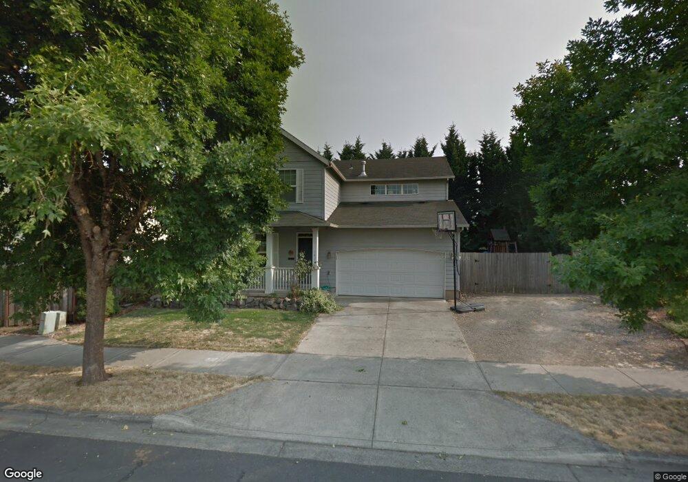
1420 Nichols Ln Forest Grove, OR 97116
Estimated Value: $513,000 - $565,439
3
Beds
3
Baths
1,870
Sq Ft
$285/Sq Ft
Est. Value
About This Home
This home is located at 1420 Nichols Ln, Forest Grove, OR 97116 and is currently estimated at $533,610, approximately $285 per square foot. 1420 Nichols Ln is a home located in Washington County with nearby schools including Harvey Clarke Elementary School, Tom McCall Upper Elementary School, and Neil Armstrong Middle School.
Ownership History
Date
Name
Owned For
Owner Type
Purchase Details
Closed on
Oct 31, 2006
Sold by
Breadon Tom and Breadon Kellie
Bought by
Colfelt Stephen J and Colfelt Trista A
Current Estimated Value
Home Financials for this Owner
Home Financials are based on the most recent Mortgage that was taken out on this home.
Original Mortgage
$208,000
Outstanding Balance
$122,789
Interest Rate
6.36%
Mortgage Type
Unknown
Estimated Equity
$410,821
Create a Home Valuation Report for This Property
The Home Valuation Report is an in-depth analysis detailing your home's value as well as a comparison with similar homes in the area
Home Values in the Area
Average Home Value in this Area
Purchase History
| Date | Buyer | Sale Price | Title Company |
|---|---|---|---|
| Colfelt Stephen J | $275,000 | Stewart |
Source: Public Records
Mortgage History
| Date | Status | Borrower | Loan Amount |
|---|---|---|---|
| Open | Colfelt Stephen J | $208,000 |
Source: Public Records
Tax History Compared to Growth
Tax History
| Year | Tax Paid | Tax Assessment Tax Assessment Total Assessment is a certain percentage of the fair market value that is determined by local assessors to be the total taxable value of land and additions on the property. | Land | Improvement |
|---|---|---|---|---|
| 2026 | $5,308 | $298,060 | -- | -- |
| 2025 | $5,308 | $289,380 | -- | -- |
| 2024 | $5,121 | $280,960 | -- | -- |
| 2023 | $5,121 | $272,780 | $0 | $0 |
| 2022 | $4,477 | $272,780 | $0 | $0 |
| 2021 | $4,419 | $257,130 | $0 | $0 |
| 2020 | $4,396 | $249,650 | $0 | $0 |
| 2019 | $4,298 | $242,380 | $0 | $0 |
| 2018 | $4,166 | $235,330 | $0 | $0 |
| 2017 | $4,037 | $228,480 | $0 | $0 |
| 2016 | $3,924 | $221,830 | $0 | $0 |
| 2015 | $3,773 | $215,370 | $0 | $0 |
| 2014 | $3,755 | $209,100 | $0 | $0 |
Source: Public Records
Map
Nearby Homes
- 1224 Alyssum Ave
- 1425 Willamina Ave
- 1219 34th Place
- 922 Rosebud Ct
- 918 Rosebud Ct
- 1104 Magnolia Way
- 911 Rosebud Ct
- 920 Rosebud Ct
- 924 Rosebud Ct
- 3309 Butte Dr
- 3317 Butte Dr
- 507-FH Plan at Parkview Terrace
- 504-STD Plan at Parkview Terrace
- Poppy - Plan 308C at Parkview Terrace
- 430A Plan at Parkview Terrace
- Plan 400 at Parkview Terrace
- 506-FH Plan at Parkview Terrace
- Plan 325 at Parkview Terrace
- 505-STD Plan at Parkview Terrace
- 508-MFH Plan at Parkview Terrace
- 3202 Limpus Ln
- 1412 Nichols Ln
- 1417 Alyssum Ave
- 1423 Alyssum Ave
- 1409 Alyssum Ave
- 3203 Brooke St
- 1403 Alyssum Ave
- 1418 Alyssum Ave
- 3203 Limpus Ln
- 1418 Alysum
- 3129 Limpus Ln
- 0 Nichols Ln
- 1408 Alyssum Ave
- 1424 Alyssum Ave
- 1402 Alyssum Ave
- 1444 Nichols Ln
- 3204 Brooke St
- 1357 Alyssum Ave
- 3119 Limpus Ln
- 3216 Brooke St