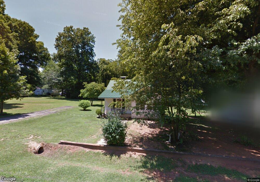
1421 Pointer St Roxboro, NC 27573
Estimated Value: $106,000 - $139,898
3
Beds
1
Bath
989
Sq Ft
$128/Sq Ft
Est. Value
About This Home
This home is located at 1421 Pointer St, Roxboro, NC 27573 and is currently estimated at $126,975, approximately $128 per square foot. 1421 Pointer St is a home located in Person County with nearby schools including Person High School, Roxboro Community School, and Roxboro Christian Academy.
Ownership History
Date
Name
Owned For
Owner Type
Purchase Details
Closed on
Mar 10, 2011
Sold by
Bullock Lumber Company Inc
Bought by
Bohannon Susan T
Current Estimated Value
Home Financials for this Owner
Home Financials are based on the most recent Mortgage that was taken out on this home.
Original Mortgage
$42,000
Interest Rate
4.76%
Mortgage Type
Purchase Money Mortgage
Purchase Details
Closed on
Jul 8, 2009
Sold by
Oliver Earl Trent and Oliver Deborah G
Bought by
Bullock Lumber Company Inc
Create a Home Valuation Report for This Property
The Home Valuation Report is an in-depth analysis detailing your home's value as well as a comparison with similar homes in the area
Purchase History
| Date | Buyer | Sale Price | Title Company |
|---|---|---|---|
| Bohannon Susan T | $42,000 | -- | |
| Bullock Lumber Company Inc | $37,500 | -- |
Source: Public Records
Mortgage History
| Date | Status | Borrower | Loan Amount |
|---|---|---|---|
| Closed | Bohannon Susan T | $42,000 |
Source: Public Records
Tax History
| Year | Tax Paid | Tax Assessment Tax Assessment Total Assessment is a certain percentage of the fair market value that is determined by local assessors to be the total taxable value of land and additions on the property. | Land | Improvement |
|---|---|---|---|---|
| 2025 | $1,203 | $94,392 | $0 | $0 |
| 2024 | $656 | $43,057 | $0 | $0 |
| 2023 | $654 | $43,057 | $0 | $0 |
| 2022 | $611 | $43,057 | $0 | $0 |
| 2021 | $590 | $43,057 | $0 | $0 |
| 2020 | $594 | $42,725 | $0 | $0 |
| 2019 | $598 | $42,725 | $0 | $0 |
| 2018 | $585 | $42,725 | $0 | $0 |
| 2017 | $585 | $42,730 | $0 | $0 |
| 2016 | $585 | $42,730 | $0 | $0 |
| 2015 | $581 | $42,730 | $0 | $0 |
| 2014 | $581 | $42,730 | $0 | $0 |
Source: Public Records
Map
Nearby Homes
- Lot 4 Forrestwood Dr
- 120 Denada Path
- 1420 John St
- 425 Providence Rd
- 1901 Carver Dr
- 474 Providence Rd
- 143 Lankford St
- 11 Denada Path
- 115 Kerr Dr
- 234 Lillian Ct
- 213 Hicks Cir
- 100 Landon Place
- 249 Landon Place
- 200 Payton Place
- 199 Payton Place
- 183 Payton Place
- 168 Payton Place
- 00 Stone Dr
- 167 Payton Place
- 150 Summit St
- 1425 Pointer St
- 1415 Pointer St
- 1422 Elm St
- 1429 Pointer St
- 1424 Elm St
- 1420 Pointer St
- 1428 Pointer St
- 1428 Elm St
- 1416 Pointer St
- 1411 Pointer St
- 1432 Pointer St
- 1408 Elm St
- 1410 Pointer St
- 1419 & 142 Elm St
- 1419 & 1421 Elm St
- 1419 Elm St
- 1419 Elm St
- 1406 Elm St
- 1419 Elm St Unit 1421
- 1407 Pointer St
Your Personal Tour Guide
Ask me questions while you tour the home.