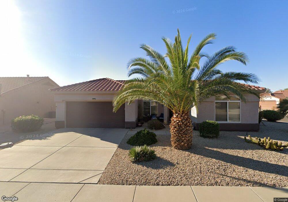
14219 W Gunsight Dr Sun City West, AZ 85375
Estimated Value: $308,249 - $367,000
2
Beds
2
Baths
1,420
Sq Ft
$243/Sq Ft
Est. Value
About This Home
This home is located at 14219 W Gunsight Dr, Sun City West, AZ 85375 and is currently estimated at $345,062, approximately $243 per square foot. 14219 W Gunsight Dr is a home located in Maricopa County with nearby schools including Asante Preparatory Academy, Cimarron Springs Middle School, and Willow Canyon High School.
Ownership History
Date
Name
Owned For
Owner Type
Purchase Details
Closed on
Sep 16, 2015
Sold by
Rokosz Richard J
Bought by
Knapp Charlene
Current Estimated Value
Purchase Details
Closed on
Jun 12, 2008
Sold by
Auchenbach J Wanda
Bought by
The Richard J Rokosz Revocable Living Tr and The Carol M Rokosz Revocable Living Tr
Purchase Details
Closed on
Oct 30, 1995
Sold by
Auchenbach Byron C and Wanda Auchenbach J
Bought by
Auchenbach Byron C and Wanda Auchenbach J
Purchase Details
Closed on
Sep 28, 1994
Sold by
Del E Webb Development Co L P
Bought by
Auchenbach Byron C and Wanda Auchenbach J
Create a Home Valuation Report for This Property
The Home Valuation Report is an in-depth analysis detailing your home's value as well as a comparison with similar homes in the area
Home Values in the Area
Average Home Value in this Area
Purchase History
| Date | Buyer | Sale Price | Title Company |
|---|---|---|---|
| Knapp Charlene | $179,500 | Equity Title Agency Inc | |
| The Richard J Rokosz Revocable Living Tr | $175,000 | Fidelity Natl Title Ins Co | |
| Auchenbach Byron C | -- | -- | |
| Auchenbach Byron C | $103,661 | Sun City Title Agency | |
| Del E Webb Development Co L P | -- | Sun City Title Agency |
Source: Public Records
Tax History Compared to Growth
Tax History
| Year | Tax Paid | Tax Assessment Tax Assessment Total Assessment is a certain percentage of the fair market value that is determined by local assessors to be the total taxable value of land and additions on the property. | Land | Improvement |
|---|---|---|---|---|
| 2025 | $1,588 | $20,182 | -- | -- |
| 2024 | $1,919 | $19,221 | -- | -- |
| 2023 | $1,919 | $25,780 | $5,150 | $20,630 |
| 2022 | $1,843 | $21,000 | $4,200 | $16,800 |
| 2021 | $1,911 | $19,180 | $3,830 | $15,350 |
| 2020 | $1,875 | $17,930 | $3,580 | $14,350 |
| 2019 | $1,828 | $15,870 | $3,170 | $12,700 |
| 2018 | $1,783 | $14,980 | $2,990 | $11,990 |
| 2017 | $1,711 | $14,170 | $2,830 | $11,340 |
| 2016 | $1,633 | $13,380 | $2,670 | $10,710 |
| 2015 | $1,744 | $12,570 | $2,510 | $10,060 |
Source: Public Records
Map
Nearby Homes
- 14209 W Territorial Ln
- 14207 W Gunsight Dr
- 22610 N Cabana Ln Unit 52
- 14117 W Pecos Ln
- 22009 N Vía de La Caballa
- 22010 N Mirage Ln
- 14317 W Robertson Dr
- 22319 N Desperado Dr
- 14133 W Vía Montoya
- 14418 W Gunsight Dr Unit 53
- 14101 W Vía Tercero
- 14416 W Robertson Dr
- 12656 W Country Club Trail
- 14429 W Wagon Wheel Dr
- 22836 N Dusty Trail Blvd
- 22318 N Dusty Trail Blvd Unit 51
- 14010 W Pavillion Dr
- 22608 N Dusty Trail Blvd
- 14332 W Dusty Trail Blvd
- 22725 N Dusty Trail Blvd
- 14215 W Gunsight Dr
- 14218 W Territorial Ln Unit 52
- 14214 W Territorial Ln
- 14220 W Gunsight Dr
- 14224 W Gunsight Dr
- 14237 W Territorial Ln
- 14233 W Territorial Ln
- 14211 W Gunsight Dr
- 14216 W Gunsight Dr
- 14228 W Gunsight Dr
- 14210 W Territorial Ln
- 14212 W Gunsight Dr
- 14217 W Colt Ln
- 14221 W Territorial Ln
- 14213 W Colt Ln Unit 52
- 14232 W Gunsight Dr
- 14217 W Territorial Ln
- 14221 W Colt Ln
- 14225 W Territorial Ln
- 14208 W Gunsight Dr