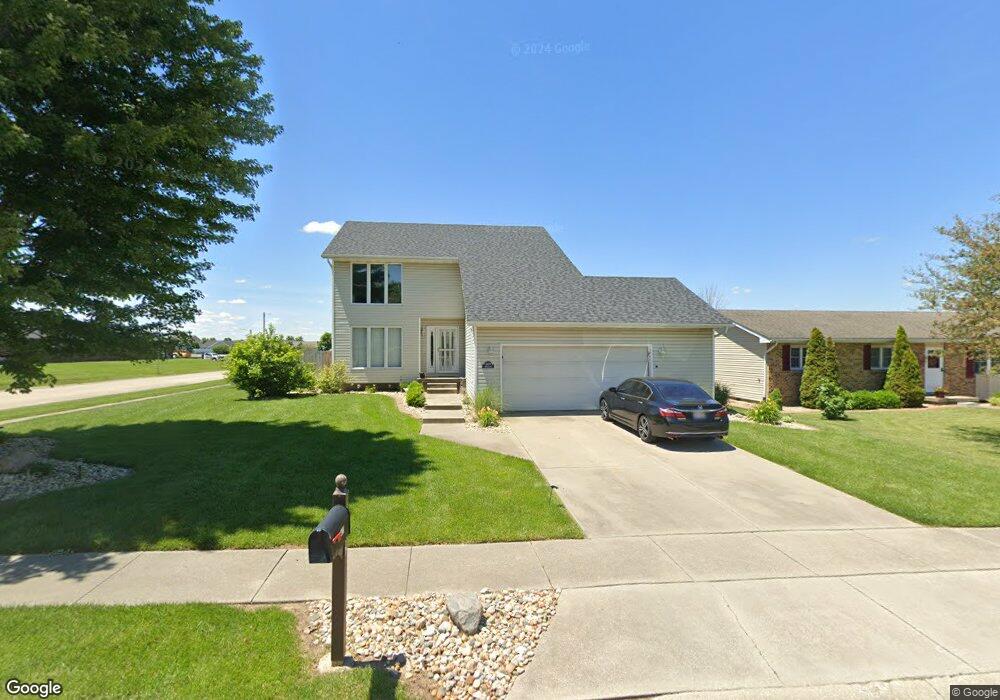
1423 Rich Ln Mount Zion, IL 62549
Estimated Value: $207,000 - $290,000
4
Beds
3
Baths
2,172
Sq Ft
$114/Sq Ft
Est. Value
About This Home
This home is located at 1423 Rich Ln, Mount Zion, IL 62549 and is currently estimated at $248,192, approximately $114 per square foot. 1423 Rich Ln is a home located in Macon County with nearby schools including McGaughey Elementary School, Mt. Zion Elementary School, and Mt. Zion Intermediate School.
Ownership History
Date
Name
Owned For
Owner Type
Purchase Details
Closed on
Jul 18, 2005
Sold by
Gehrke Bradley S and Gehrke Lori A
Bought by
Katjac Inc
Current Estimated Value
Home Financials for this Owner
Home Financials are based on the most recent Mortgage that was taken out on this home.
Original Mortgage
$132,000
Interest Rate
5.71%
Mortgage Type
New Conventional
Purchase Details
Closed on
Jun 1, 2002
Create a Home Valuation Report for This Property
The Home Valuation Report is an in-depth analysis detailing your home's value as well as a comparison with similar homes in the area
Home Values in the Area
Average Home Value in this Area
Purchase History
| Date | Buyer | Sale Price | Title Company |
|---|---|---|---|
| Katjac Inc | $163,000 | None Available | |
| -- | $145,000 | -- |
Source: Public Records
Mortgage History
| Date | Status | Borrower | Loan Amount |
|---|---|---|---|
| Closed | Katjac Inc | $132,000 |
Source: Public Records
Tax History Compared to Growth
Tax History
| Year | Tax Paid | Tax Assessment Tax Assessment Total Assessment is a certain percentage of the fair market value that is determined by local assessors to be the total taxable value of land and additions on the property. | Land | Improvement |
|---|---|---|---|---|
| 2024 | $4,847 | $68,091 | $6,050 | $62,041 |
| 2023 | $4,682 | $63,329 | $5,627 | $57,702 |
| 2022 | $4,474 | $60,068 | $5,338 | $54,730 |
| 2021 | $4,337 | $56,273 | $5,000 | $51,273 |
| 2020 | $4,630 | $60,304 | $6,030 | $54,274 |
| 2019 | $4,630 | $60,304 | $6,030 | $54,274 |
| 2018 | $4,488 | $58,764 | $5,876 | $52,888 |
| 2017 | $4,941 | $57,634 | $5,763 | $51,871 |
| 2016 | $4,901 | $56,632 | $5,663 | $50,969 |
| 2015 | $4,744 | $56,071 | $5,607 | $50,464 |
| 2014 | $4,574 | $56,071 | $5,607 | $50,464 |
| 2013 | $4,627 | $56,071 | $5,607 | $50,464 |
Source: Public Records
Map
Nearby Homes
- 1610 Robin Ct
- 50 Sundance Dr
- 925 S Wildwood Dr
- 860 W Wildwood Dr
- 1820 Buckhead Ln
- 2125 Buckhead Ave
- 2110 Buckhead Ln
- 2130 Buckhead Ave
- 1935 Buckhead Ct
- 1625 Ridgewood Ct
- 570 Fawn Ct
- 2020 Buckhead Ln
- 2030 Buckhead Ln
- 3330 S Baltimore Ave
- 265 Carrington Ave
- 3930 S Mount Zion Rd
- 125 W Walnut St
- 1440 N Alexander Dr
- 524 Elm St
- 820 Kirk Dr