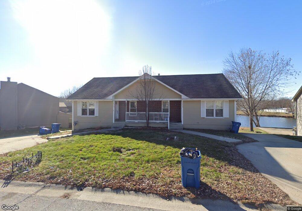
1424 Laurel St Kearney, MO 64060
Estimated Value: $301,000 - $359,000
4
Beds
2
Baths
1,808
Sq Ft
$183/Sq Ft
Est. Value
About This Home
This home is located at 1424 Laurel St, Kearney, MO 64060 and is currently estimated at $330,948, approximately $183 per square foot. 1424 Laurel St is a home located in Clay County with nearby schools including Kearney Junior High School, Kearney High School, and Northern Hills Christian Academy.
Ownership History
Date
Name
Owned For
Owner Type
Purchase Details
Closed on
Dec 4, 2023
Sold by
Ferrell William James
Bought by
William James Ferrell H Living Trust and Ferrell
Current Estimated Value
Purchase Details
Closed on
Jul 3, 2018
Sold by
Rhoades Properties Llc
Bought by
Ferrell William
Home Financials for this Owner
Home Financials are based on the most recent Mortgage that was taken out on this home.
Original Mortgage
$130,125
Interest Rate
4.5%
Mortgage Type
New Conventional
Purchase Details
Closed on
Jun 7, 2012
Sold by
Voss Family Properties Llc
Bought by
Rhoades Properties Llc
Home Financials for this Owner
Home Financials are based on the most recent Mortgage that was taken out on this home.
Original Mortgage
$76,500
Interest Rate
3.86%
Mortgage Type
Future Advance Clause Open End Mortgage
Create a Home Valuation Report for This Property
The Home Valuation Report is an in-depth analysis detailing your home's value as well as a comparison with similar homes in the area
Home Values in the Area
Average Home Value in this Area
Purchase History
We collect this data history from publicly available records. To have your information removed, we recommend requesting removal directly through your county’s website.
| Date | Buyer | Sale Price | Title Company |
|---|---|---|---|
| William James Ferrell H Living Trust | -- | None Listed On Document | |
| Ferrell William | -- | Stewart Title Co | |
| Rhoades Properties Llc | -- | Stewart Title Company Midwes |
Source: Public Records
Mortgage History
We collect this data history from publicly available records. To have your information removed, we recommend requesting removal directly through your county’s website.
| Date | Status | Borrower | Loan Amount |
|---|---|---|---|
| Previous Owner | Ferrell William | $130,125 | |
| Previous Owner | Rhoades Properties Llc | $76,500 |
Source: Public Records
Tax History
| Year | Tax Paid | Tax Assessment Tax Assessment Total Assessment is a certain percentage of the fair market value that is determined by local assessors to be the total taxable value of land and additions on the property. | Land | Improvement |
|---|---|---|---|---|
| 2025 | $3,202 | $48,260 | -- | -- |
| 2024 | $3,202 | $46,720 | -- | -- |
| 2023 | $3,191 | $46,720 | $0 | $0 |
| 2022 | $2,865 | $40,570 | $0 | $0 |
| 2021 | $2,809 | $40,565 | $4,750 | $35,815 |
| 2020 | $2,730 | $35,870 | $0 | $0 |
| 2019 | $2,716 | $60,416 | $8,000 | $52,416 |
| 2018 | $2,255 | $28,770 | $0 | $0 |
| 2017 | $2,134 | $28,770 | $3,040 | $25,730 |
| 2016 | $2,134 | $27,510 | $4,370 | $23,140 |
| 2015 | $2,134 | $27,510 | $4,370 | $23,140 |
| 2014 | $2,144 | $27,510 | $4,370 | $23,140 |
Source: Public Records
Map
Nearby Homes
- 1304 S Jefferson St
- 1301 Ada St
- 1404 Colony Dr
- 1314 Susan St
- 621 E 13th St
- 623 E 13th St
- 406 E 11th St
- 1206 Noah Ln
- 1107 Halle Dr
- 1925 Meadowlane
- 903 S Jefferson St
- 707 E 18th St
- 1307 Stonecrest Dr
- 1305 Stonecrest Dr
- 1845 Falcon Ct
- 905 Oak Ridge
- 800 E 13th Terrace
- 1709 Park Ln
- 2001 Foxtail Point
- 1104 Regency Dr
- 1422 Laurel St
- 1420 Laurel St
- 1428 Laurel St
- 1501 Laurel St
- 1416 Laurel St
- 1505 Laurel St
- 1411 Laurel St
- 304 Southbrook Pkwy
- 1412 Laurel St
- 1409 Laurel St
- 308 Southbrook Pkwy
- 215 Southbrook Pkwy
- 1405 Laurel St
- 1408 Laurel St
- 312 Southbrook Pkwy
- 1503 S Prospect St
- 301 Southbrook Pkwy
- 401 Southbrook Pkwy
- 1505 S Prospect St
- 1501 S Prospect St
Your Personal Tour Guide
Ask me questions while you tour the home.