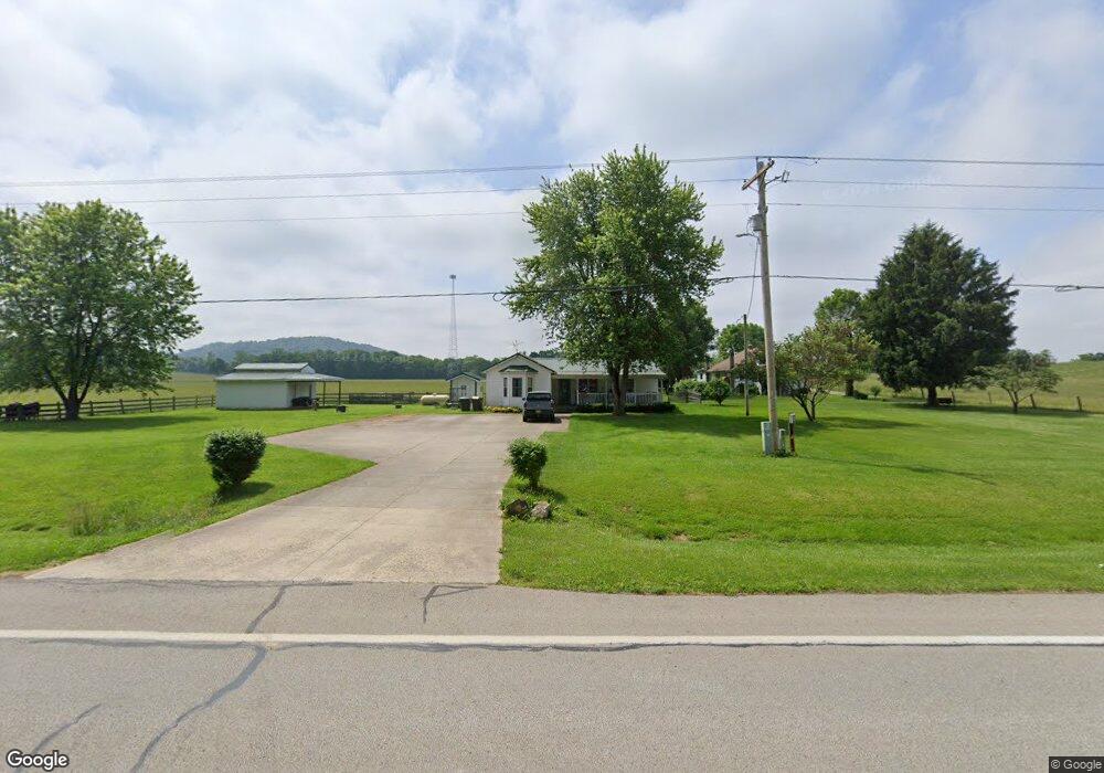
14254 Us Highway 50 W Bainbridge, OH 45612
Estimated Value: $122,000 - $236,000
3
Beds
2
Baths
1,440
Sq Ft
$119/Sq Ft
Est. Value
About This Home
This home is located at 14254 Us Highway 50 W, Bainbridge, OH 45612 and is currently estimated at $171,386, approximately $119 per square foot. 14254 Us Highway 50 W is a home located in Highland County with nearby schools including McClain High School.
Ownership History
Date
Name
Owned For
Owner Type
Purchase Details
Closed on
Jun 25, 2020
Sold by
Ewry Lewis D and Ewry Misty T
Bought by
Rlt Lewis D Ewry An D Misty T Ewry
Current Estimated Value
Purchase Details
Closed on
Feb 25, 1999
Sold by
Corn Nancy S
Bought by
Ewry Lewis D
Home Financials for this Owner
Home Financials are based on the most recent Mortgage that was taken out on this home.
Original Mortgage
$33,500
Interest Rate
6.92%
Mortgage Type
Balloon
Purchase Details
Closed on
Jan 1, 1990
Bought by
Corn Nancy S
Create a Home Valuation Report for This Property
The Home Valuation Report is an in-depth analysis detailing your home's value as well as a comparison with similar homes in the area
Home Values in the Area
Average Home Value in this Area
Purchase History
| Date | Buyer | Sale Price | Title Company |
|---|---|---|---|
| Rlt Lewis D Ewry An D Misty T Ewry | -- | None Available | |
| Ewry Lewis D | $35,000 | -- | |
| Corn Nancy S | -- | -- |
Source: Public Records
Mortgage History
| Date | Status | Borrower | Loan Amount |
|---|---|---|---|
| Previous Owner | Ewry Lewis D | $33,500 |
Source: Public Records
Tax History Compared to Growth
Tax History
| Year | Tax Paid | Tax Assessment Tax Assessment Total Assessment is a certain percentage of the fair market value that is determined by local assessors to be the total taxable value of land and additions on the property. | Land | Improvement |
|---|---|---|---|---|
| 2024 | $1,092 | $35,530 | $6,720 | $28,810 |
| 2023 | $1,092 | $27,370 | $5,740 | $21,630 |
| 2022 | $930 | $27,370 | $5,740 | $21,630 |
| 2021 | $883 | $27,370 | $5,740 | $21,630 |
| 2020 | $758 | $22,830 | $4,800 | $18,030 |
| 2019 | $769 | $22,830 | $4,800 | $18,030 |
| 2018 | $773 | $22,830 | $4,800 | $18,030 |
| 2017 | $701 | $20,580 | $4,900 | $15,680 |
| 2016 | $704 | $20,580 | $4,900 | $15,680 |
| 2015 | $366 | $20,580 | $4,900 | $15,680 |
| 2014 | $753 | $19,610 | $4,660 | $14,950 |
| 2013 | $377 | $19,610 | $4,660 | $14,950 |
Source: Public Records
Map
Nearby Homes
- 7724 Cave Rd
- 14703 Brier Rd
- 12977 U S 50
- 61 Maple Dr
- 355 Maple Dr
- 0 Maple Dr Unit 1841507
- 6838 McCoppin Mill Rd
- 1540 Cove Run Rd
- 6935 Laura Blvd
- 0 Martha Dr Unit 1857951
- 0.459ac Lakefront Dr
- 7094 Cedar Trail
- 5233 Rapid Forge Rd
- 11850 Maple Trail
- 11245 Karnes Rd
- 213 S Benner Hill Rd
- 6749 Loch Lomond Cir
- 11515 Dundee Dr
- 301 N Maple St
- 201 N Maple St
- 14308 U S 50
- 14340 Us Highway 50 W
- 14148 Us Rt 50
- 14148 Us Highway 50 W
- 14148 Us Highway 50 W Unit 50
- 14136 Us Highway 50 W
- 14126 Us Highway 50 W
- 14104 Us Highway 50 W
- 14480 Us Highway 50 W
- 7573 Cave Rd
- 7629 Cave Rd
- 0 Cave Rd
- 1/2 Cave Rd
- 7590 Browning Rd
- 7381 Cave Rd
- 7506 Cave Rd
- 7442 Browning Rd
- 7603 Browning Rd
- 7660 Cave Rd
- 7446 Browning Rd