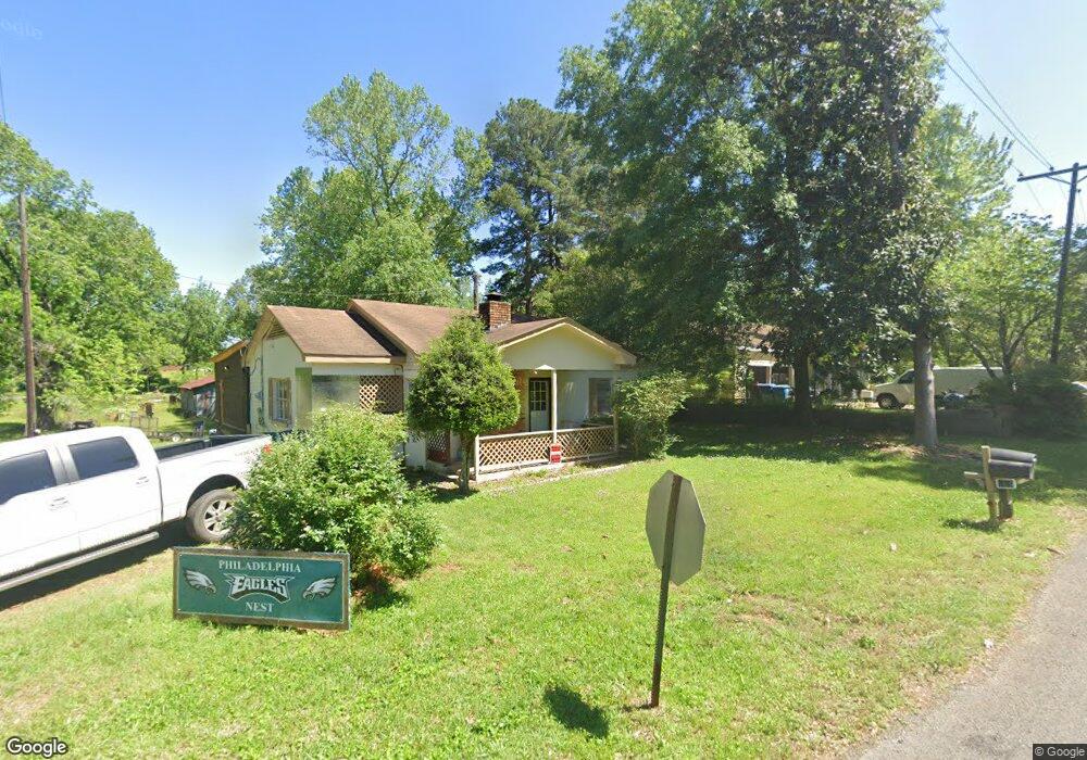
1426 6th St Gibsland, LA 71028
Estimated Value: $42,000 - $92,000
2
Beds
1
Bath
--
Sq Ft
10,019
Sq Ft Lot
About This Home
This home is located at 1426 6th St, Gibsland, LA 71028 and is currently estimated at $71,690. 1426 6th St is a home with nearby schools including Gibsland-Coleman High School.
Ownership History
Date
Name
Owned For
Owner Type
Purchase Details
Closed on
Jun 7, 2023
Sold by
Vernon Kenneth Wayne
Bought by
Miles Lamont A and Miles Valerie
Current Estimated Value
Home Financials for this Owner
Home Financials are based on the most recent Mortgage that was taken out on this home.
Original Mortgage
$50,000,000
Interest Rate
6.43%
Mortgage Type
New Conventional
Purchase Details
Closed on
Jun 2, 2016
Sold by
Gibsland Bank & Trust Company
Bought by
Vernon Kenneth Wayne
Create a Home Valuation Report for This Property
The Home Valuation Report is an in-depth analysis detailing your home's value as well as a comparison with similar homes in the area
Home Values in the Area
Average Home Value in this Area
Purchase History
| Date | Buyer | Sale Price | Title Company |
|---|---|---|---|
| Miles Lamont A | -- | None Listed On Document | |
| Vernon Kenneth Wayne | $22,000 | None Available |
Source: Public Records
Mortgage History
| Date | Status | Borrower | Loan Amount |
|---|---|---|---|
| Closed | Miles Lamont A | $50,000,000 |
Source: Public Records
Tax History Compared to Growth
Tax History
| Year | Tax Paid | Tax Assessment Tax Assessment Total Assessment is a certain percentage of the fair market value that is determined by local assessors to be the total taxable value of land and additions on the property. | Land | Improvement |
|---|---|---|---|---|
| 2024 | $1,078 | $7,302 | $160 | $7,142 |
| 2023 | $316 | $2,493 | $103 | $2,390 |
| 2022 | $311 | $2,493 | $103 | $2,390 |
| 2021 | $351 | $2,493 | $103 | $2,390 |
| 2020 | $332 | $2,493 | $103 | $2,390 |
| 2019 | $290 | $2,200 | $50 | $2,150 |
| 2018 | $288 | $2,200 | $50 | $2,150 |
| 2017 | $304 | $2,200 | $50 | $2,150 |
| 2016 | $304 | $2,200 | $50 | $2,150 |
| 2015 | $249 | $1,900 | $160 | $1,740 |
| 2014 | $207 | $0 | $0 | $0 |
| 2013 | $236 | $0 | $0 | $0 |
Source: Public Records
Map
Nearby Homes
- 1910 Main St
- 1432 Louisiana 795
- 12801 Highway 154
- Cato Rd
- 0 Oscar Kilpatrick Rd
- Penal Farm Road Lot Unit Wp001
- 2539 Corley St
- 780 Barnes Rd
- 0 Rural Unit 21124258
- 15520 Highway 9
- 2184 2nd St
- 1977 S Railroad Ave
- 1646 Sycamore St
- 2070 Hazel St
- 2114 Laurel St
- 3936 College St
- 0 Hazel St
- 0 Hazel St Unit 2530676
- 1618 Hazel St
- 000 Daniel St