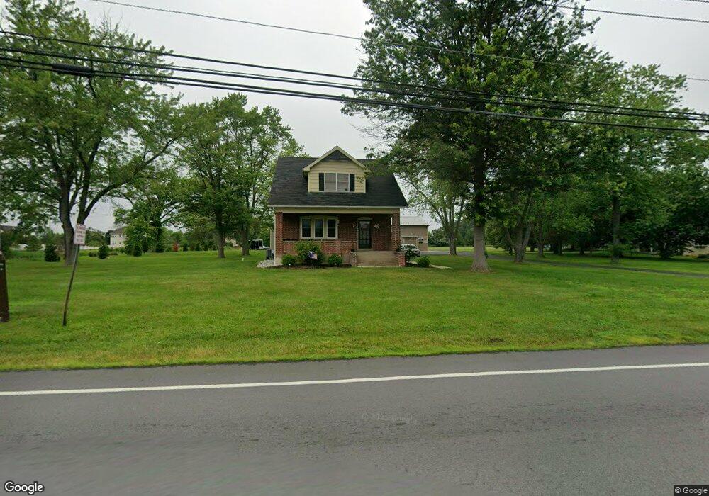
1426 Derstine Rd Souderton, PA 18964
Estimated Value: $551,000 - $558,709
3
Beds
2
Baths
1,175
Sq Ft
$472/Sq Ft
Est. Value
About This Home
This home is located at 1426 Derstine Rd, Souderton, PA 18964 and is currently estimated at $554,855, approximately $472 per square foot. 1426 Derstine Rd is a home with nearby schools including Walton Farm El School, Pennfield Middle School, and North Penn Senior High School.
Ownership History
Date
Name
Owned For
Owner Type
Purchase Details
Closed on
Mar 29, 2021
Sold by
Moyer Norman G and Moyer Gerald M
Bought by
Gavin Property Management Llc
Current Estimated Value
Home Financials for this Owner
Home Financials are based on the most recent Mortgage that was taken out on this home.
Original Mortgage
$504,000
Outstanding Balance
$455,415
Interest Rate
3.05%
Mortgage Type
New Conventional
Estimated Equity
$99,440
Purchase Details
Closed on
Mar 27, 2001
Sold by
Moyer Norman G and Moyer Edith M
Bought by
Moyer Norman G
Create a Home Valuation Report for This Property
The Home Valuation Report is an in-depth analysis detailing your home's value as well as a comparison with similar homes in the area
Home Values in the Area
Average Home Value in this Area
Purchase History
| Date | Buyer | Sale Price | Title Company |
|---|---|---|---|
| Gavin Property Management Llc | $420,000 | None Available | |
| Moyer Norman G | -- | -- |
Source: Public Records
Mortgage History
| Date | Status | Borrower | Loan Amount |
|---|---|---|---|
| Open | Gavin Property Management Llc | $504,000 |
Source: Public Records
Tax History Compared to Growth
Tax History
| Year | Tax Paid | Tax Assessment Tax Assessment Total Assessment is a certain percentage of the fair market value that is determined by local assessors to be the total taxable value of land and additions on the property. | Land | Improvement |
|---|---|---|---|---|
| 2025 | $3,992 | $99,720 | -- | -- |
| 2024 | $3,992 | $99,720 | -- | -- |
| 2023 | $3,822 | $99,720 | $0 | $0 |
| 2022 | $3,697 | $369,660 | $277,980 | $91,680 |
| 2021 | $3,592 | $369,660 | $277,980 | $91,680 |
| 2020 | $3,507 | $369,660 | $277,980 | $91,680 |
| 2019 | $3,448 | $369,660 | $277,980 | $91,680 |
| 2018 | $3,449 | $369,660 | $277,980 | $91,680 |
| 2017 | $3,317 | $369,660 | $277,980 | $91,680 |
| 2016 | $3,278 | $369,660 | $277,980 | $91,680 |
| 2015 | $3,147 | $369,660 | $277,980 | $91,680 |
| 2014 | $3,147 | $369,660 | $277,980 | $91,680 |
Source: Public Records
Map
Nearby Homes
- 1064 Grayson Dr
- 1520 Fairgrounds Rd
- 2031 Oak Ave
- 2689 Jean Dr
- 27 W School St
- 101 Leslie Ln
- 142 Orchard Ln
- 43 June Dr
- Westchester Plan at Reserve at Franconia
- Ashton Plan at Reserve at Franconia - Townhomes Series
- 138 Diamond St Unit 31
- 723 Finlay Dr
- 1116 Arthur Dr
- 302 W Broad St
- 381 Brittany Ct
- 3 Diamond St
- 105 S Main St
- 552 Creekside Dr
- 333 Union St Unit 4
- 635 Elroy Rd
- 1660 Derstine Rd
- 1429 Derstine Rd
- 1505 Bellevue Ln
- 1310 Grayson Dr
- 1308 Grayson Dr
- 1503 Bellevue Ln
- 1407 Derstine Rd
- 1419 Derstine Rd
- 1306 Grayson Dr
- 1304 Grayson Dr
- 1540 Bergey Rd
- 1307 Grayson Dr
- 1560 Bergey Rd
- 1750 Derstine Rd
- 1305 Grayson Dr
- 1506 Bellevue Ln
- 1580 Bergey Rd
- 1302 Grayson Dr
- 1504 Bellevue Ln
- 1300 Grayson Dr