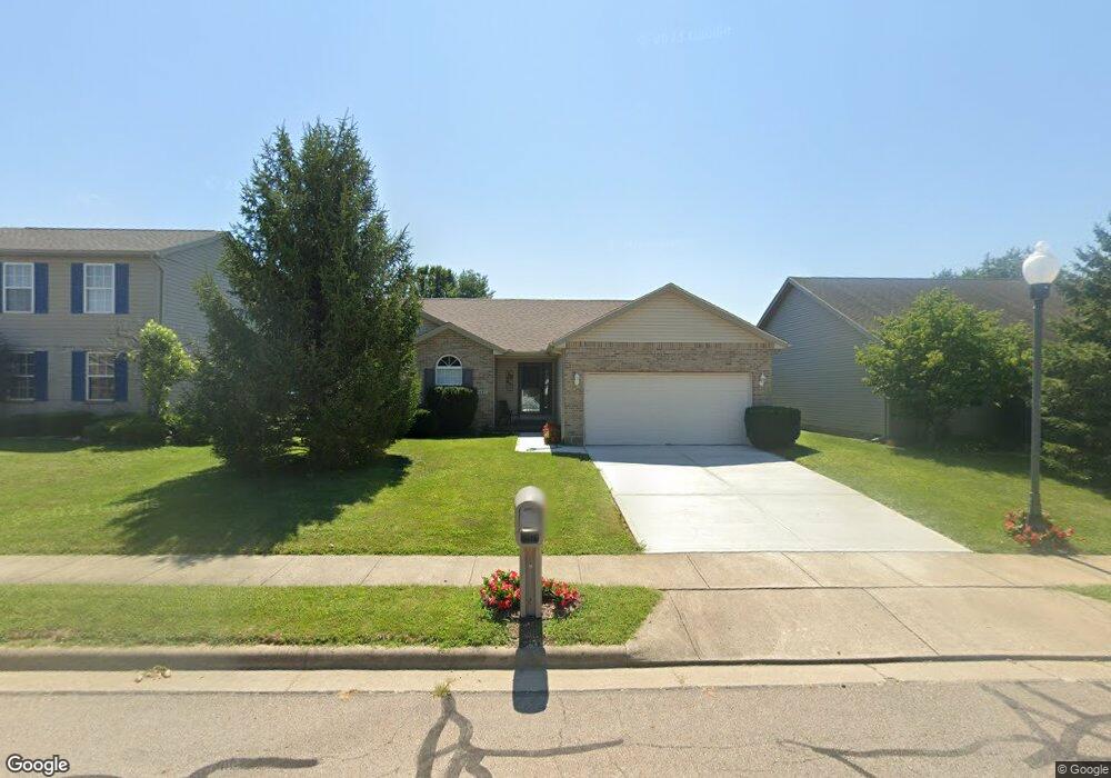
1427 Woodside Dr Wilmington, OH 45177
Estimated Value: $261,167 - $304,000
3
Beds
2
Baths
1,444
Sq Ft
$195/Sq Ft
Est. Value
About This Home
This home is located at 1427 Woodside Dr, Wilmington, OH 45177 and is currently estimated at $281,292, approximately $194 per square foot. 1427 Woodside Dr is a home located in Clinton County with nearby schools including East End Elementary School, Roy E. Holmes Elementary School, and Denver Place Elementary School.
Ownership History
Date
Name
Owned For
Owner Type
Purchase Details
Closed on
Jan 31, 2018
Sold by
Connor Jack and Connor Carolyn Lily
Bought by
Connor Family Joint Revocable Trust
Current Estimated Value
Purchase Details
Closed on
Jan 2, 2018
Sold by
Jhn Properties Llc
Bought by
Connor Jack and Connor Carolyn
Purchase Details
Closed on
Sep 20, 2017
Sold by
Glenn & Miriam Murphy Farms Family Limit
Bought by
Jhn Properties Llc
Purchase Details
Closed on
Apr 29, 2003
Sold by
Peelle Walter J and Peelle Dollie S
Bought by
Murphy Glenn and Murphy Miriam
Purchase Details
Closed on
Jul 12, 2002
Sold by
Big Six
Bought by
Peelle Walter J and Peelle Dollie S
Purchase Details
Closed on
Jan 1, 1990
Bought by
Big Six Partnership
Create a Home Valuation Report for This Property
The Home Valuation Report is an in-depth analysis detailing your home's value as well as a comparison with similar homes in the area
Home Values in the Area
Average Home Value in this Area
Purchase History
| Date | Buyer | Sale Price | Title Company |
|---|---|---|---|
| Connor Family Joint Revocable Trust | -- | None Available | |
| Connor Jack | $145,000 | Trico Title Inc | |
| Jhn Properties Llc | $110,000 | Trico Title Inc | |
| Murphy Glenn | $120,000 | -- | |
| Peelle Walter J | $80,000 | -- | |
| Big Six Partnership | -- | -- |
Source: Public Records
Tax History Compared to Growth
Tax History
| Year | Tax Paid | Tax Assessment Tax Assessment Total Assessment is a certain percentage of the fair market value that is determined by local assessors to be the total taxable value of land and additions on the property. | Land | Improvement |
|---|---|---|---|---|
| 2024 | $2,273 | $67,690 | $9,240 | $58,450 |
| 2023 | $2,273 | $67,690 | $9,240 | $58,450 |
| 2022 | $2,025 | $56,750 | $7,980 | $48,770 |
| 2021 | $2,049 | $56,750 | $7,980 | $48,770 |
| 2020 | $1,926 | $56,750 | $7,980 | $48,770 |
| 2019 | $2,410 | $42,710 | $7,980 | $34,730 |
| 2018 | $1,646 | $42,710 | $7,980 | $34,730 |
| 2017 | $800 | $42,710 | $7,980 | $34,730 |
| 2016 | $1,450 | $38,220 | $7,980 | $30,240 |
| 2015 | $1,427 | $38,220 | $7,980 | $30,240 |
| 2013 | $1,411 | $37,350 | $7,980 | $29,370 |
Source: Public Records
Map
Nearby Homes
- 1706 Woodside Dr
- 1247 Peggy Ln
- 1351 Mayfair Dr
- 629 Oakridge Dr
- 585 Silverado Dr
- 1244 Mayfair Dr
- 588 John Chambers Dr
- 987 N Nelson Ave
- 909 W Main St
- 423 Howard St
- 2536 Wayne Rd
- 373 Thorne Ave
- 584 Howard St
- 493 Mitchell Rd
- 555 Cross Creek Dr
- 360 Summit St
- 0 N Wood St
- 328 A St
- 1087 Warren Dr
- 421 N Spring St
- 1437 Woodside Dr
- 1417 Woodside Dr
- 590 Westwynd Cir
- 1447 Woodside Dr
- 1409 Woodside Dr
- 587 Westwynd Cir
- 601 Quiet Creek Ct
- 1457 Woodside Dr
- 1420 Woodside Dr
- 582 Westwynd Cir
- 1410 Woodside Dr
- 585 N Nelson Ave
- 571 Westwynd Cir
- 1469 Woodside Dr
- 565 N Nelson Ave
- 665 Quiet Creek Ct
- 568 Westwynd Cir
- 1489 Woodside Dr
- 559 Westwynd Cir