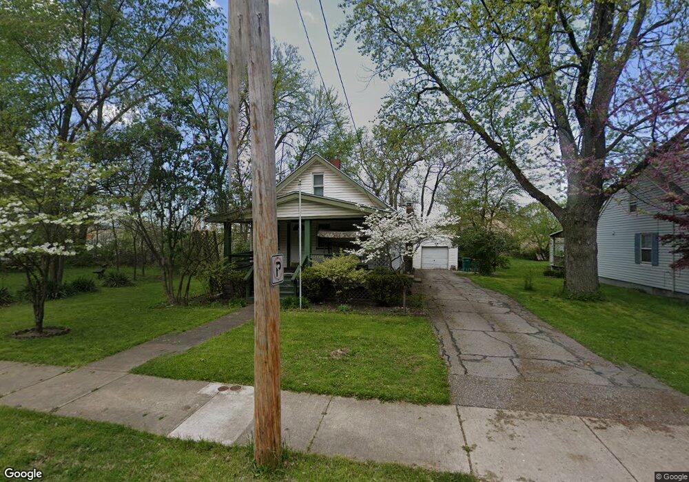
14275 Maple Ave Maple Heights, OH 44137
Estimated Value: $70,000 - $171,000
3
Beds
1
Bath
968
Sq Ft
$116/Sq Ft
Est. Value
About This Home
This home is located at 14275 Maple Ave, Maple Heights, OH 44137 and is currently estimated at $112,617, approximately $116 per square foot. 14275 Maple Ave is a home located in Cuyahoga County with nearby schools including Abraham Lincoln Elementary School, Rockside/ J.F. Kennedy School, and Barack Obama School.
Ownership History
Date
Name
Owned For
Owner Type
Purchase Details
Closed on
Aug 17, 1999
Sold by
Faivre Regis V and Faivre Robin R
Bought by
Watson Thomas G
Current Estimated Value
Home Financials for this Owner
Home Financials are based on the most recent Mortgage that was taken out on this home.
Original Mortgage
$81,498
Outstanding Balance
$23,603
Interest Rate
7.75%
Mortgage Type
VA
Estimated Equity
$89,014
Purchase Details
Closed on
Apr 3, 1985
Sold by
Faivre Regis V
Bought by
Faivre Regis and Faivre Robin R
Purchase Details
Closed on
Dec 17, 1982
Sold by
Puleo Steve V and Puleo Betty G
Bought by
Faivre Regis
Purchase Details
Closed on
Apr 30, 1982
Sold by
Low Louise
Bought by
Puleo Steve and Puleo Betty G
Purchase Details
Closed on
Jan 1, 1975
Bought by
Low Louise
Create a Home Valuation Report for This Property
The Home Valuation Report is an in-depth analysis detailing your home's value as well as a comparison with similar homes in the area
Home Values in the Area
Average Home Value in this Area
Purchase History
| Date | Buyer | Sale Price | Title Company |
|---|---|---|---|
| Watson Thomas G | $79,900 | Executive Title Agency Corp | |
| Faivre Regis | -- | -- | |
| Faivre Regis | $35,500 | -- | |
| Puleo Steve | $21,000 | -- | |
| Low Louise | -- | -- |
Source: Public Records
Mortgage History
| Date | Status | Borrower | Loan Amount |
|---|---|---|---|
| Open | Watson Thomas G | $81,498 |
Source: Public Records
Tax History Compared to Growth
Tax History
| Year | Tax Paid | Tax Assessment Tax Assessment Total Assessment is a certain percentage of the fair market value that is determined by local assessors to be the total taxable value of land and additions on the property. | Land | Improvement |
|---|---|---|---|---|
| 2024 | $2,643 | $28,000 | $7,805 | $20,195 |
| 2023 | $2,341 | $21,500 | $4,590 | $16,910 |
| 2022 | $2,332 | $21,490 | $4,590 | $16,910 |
| 2021 | $2,483 | $21,490 | $4,590 | $16,910 |
| 2020 | $2,127 | $16,280 | $3,470 | $12,810 |
| 2019 | $2,113 | $46,500 | $9,900 | $36,600 |
| 2018 | $2,102 | $16,280 | $3,470 | $12,810 |
| 2017 | $2,176 | $16,600 | $4,380 | $12,220 |
| 2016 | $2,103 | $16,600 | $4,380 | $12,220 |
| 2015 | $1,994 | $16,600 | $4,380 | $12,220 |
| 2014 | $1,994 | $17,120 | $4,520 | $12,600 |
Source: Public Records
Map
Nearby Homes
- 5197 Milo Ave
- 5220 Forest Ave
- 5251 Forest Ave
- 14305 Granger Rd
- 5270 E 135th St
- 14567 Pease Rd
- 5100 Greenhurst Dr
- 4955 E 141st St
- 13704 Linn Ave
- 15095 Granger Rd
- 13719 Wolf Ave
- 5353 E 129th St
- 15911 Friend Ave
- 13008 Willard Ave
- 14417 Corridon Ave
- 16174 Friendly St
- 12913 Darlington Ave
- 12516 Park Knoll Dr
- 4754 Lawrence Ave
- 12514 Park Knoll Dr
- 14221 Maple Ave
- 14301 Maple Ave
- 14305 Maple Ave
- 5190 Beech Ave
- 5194 Beech Ave
- 5198 Beech Ave
- 14309 Maple Ave
- 5202 Beech Ave
- 14149 Maple Ave
- 5206 Beech Ave
- 5190 Forest Ave
- 14317 Maple Ave
- 14147 Maple Ave
- 5210 Beech Ave
- 5198 Forest Ave
- 14306 Maple Ave
- 14323 Maple Ave
- 5223 Forest Ave
- 5202 Forest Ave
- 14129 Maple Ave