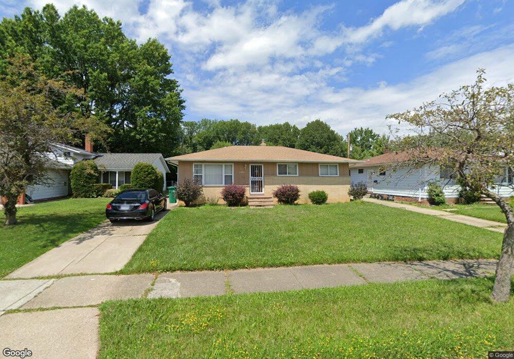
14283 Lisa Dr Maple Heights, OH 44137
Estimated Value: $138,000 - $181,000
3
Beds
1
Bath
1,066
Sq Ft
$146/Sq Ft
Est. Value
About This Home
This home is located at 14283 Lisa Dr, Maple Heights, OH 44137 and is currently estimated at $155,877, approximately $146 per square foot. 14283 Lisa Dr is a home located in Cuyahoga County with nearby schools including Abraham Lincoln Elementary School, Rockside/ J.F. Kennedy School, and Barack Obama School.
Ownership History
Date
Name
Owned For
Owner Type
Purchase Details
Closed on
Aug 20, 2010
Sold by
Deutsche Bank National Trust
Bought by
Hanson Joanne
Current Estimated Value
Purchase Details
Closed on
Nov 23, 2009
Sold by
Bowen Clyde
Bought by
Deutsche Bank National Trust Company
Purchase Details
Closed on
Dec 15, 2005
Sold by
Hud
Bought by
Bowen Clyde
Home Financials for this Owner
Home Financials are based on the most recent Mortgage that was taken out on this home.
Original Mortgage
$81,900
Interest Rate
7.95%
Mortgage Type
Purchase Money Mortgage
Purchase Details
Closed on
Aug 4, 2005
Sold by
Reid Tiffany R
Bought by
Hud
Purchase Details
Closed on
Sep 27, 2001
Sold by
Farley Joseph J and Burke Patricia A
Bought by
Reid Tiffany R
Home Financials for this Owner
Home Financials are based on the most recent Mortgage that was taken out on this home.
Original Mortgage
$94,192
Interest Rate
6.99%
Mortgage Type
FHA
Purchase Details
Closed on
Feb 1, 1984
Sold by
Farley Joseph J and Farley Beatrice M
Bought by
Farley Joseph J
Purchase Details
Closed on
Jan 1, 1975
Bought by
Farley Joseph J and Farley Beatrice M
Create a Home Valuation Report for This Property
The Home Valuation Report is an in-depth analysis detailing your home's value as well as a comparison with similar homes in the area
Home Values in the Area
Average Home Value in this Area
Purchase History
| Date | Buyer | Sale Price | Title Company |
|---|---|---|---|
| Hanson Joanne | $34,750 | Attorney | |
| Deutsche Bank National Trust Company | $36,667 | Attorney | |
| Bowen Clyde | $91,000 | Lakeside Title & Escrow Agen | |
| Hud | $90,000 | Ohio Title Corp | |
| Reid Tiffany R | $95,700 | -- | |
| Farley Joseph J | -- | -- | |
| Farley Joseph J | -- | -- |
Source: Public Records
Mortgage History
| Date | Status | Borrower | Loan Amount |
|---|---|---|---|
| Previous Owner | Bowen Clyde | $81,900 | |
| Previous Owner | Reid Tiffany R | $94,192 |
Source: Public Records
Tax History Compared to Growth
Tax History
| Year | Tax Paid | Tax Assessment Tax Assessment Total Assessment is a certain percentage of the fair market value that is determined by local assessors to be the total taxable value of land and additions on the property. | Land | Improvement |
|---|---|---|---|---|
| 2024 | $4,505 | $50,050 | $8,785 | $41,265 |
| 2023 | $3,144 | $29,580 | $7,490 | $22,090 |
| 2022 | $3,133 | $29,580 | $7,490 | $22,090 |
| 2021 | $3,348 | $29,580 | $7,490 | $22,090 |
| 2020 | $3,045 | $24,220 | $6,130 | $18,100 |
| 2019 | $3,031 | $69,200 | $17,500 | $51,700 |
| 2018 | $3,016 | $24,220 | $6,130 | $18,100 |
| 2017 | $2,847 | $22,160 | $4,340 | $17,820 |
| 2016 | $2,753 | $22,160 | $4,340 | $17,820 |
| 2015 | $2,724 | $22,160 | $4,340 | $17,820 |
| 2014 | $2,724 | $23,840 | $4,660 | $19,180 |
Source: Public Records
Map
Nearby Homes
- 14775 Lisa Dr
- 13835 Milo Rd
- 13732 Carpenter Rd
- 14917 Summit Ave
- 13804 Rockside Rd
- 14916 Summit Ave
- 13712 Rockside Rd
- SL15 Rocky Top Ct
- 6318 Valley Ranch Dr
- 5843 Dunham Rd
- 6030 Dunham Rd
- 14951 Carol Dr
- 14708 Brunswick Ave
- 14214 Tabor Ave
- 14106 Tabor Ave
- 13578 Foxcroft Dr
- 6089 Dunham Rd
- 13577 Robinhood Dr
- 14203 Tabor Ave
- 12955 Milo Rd