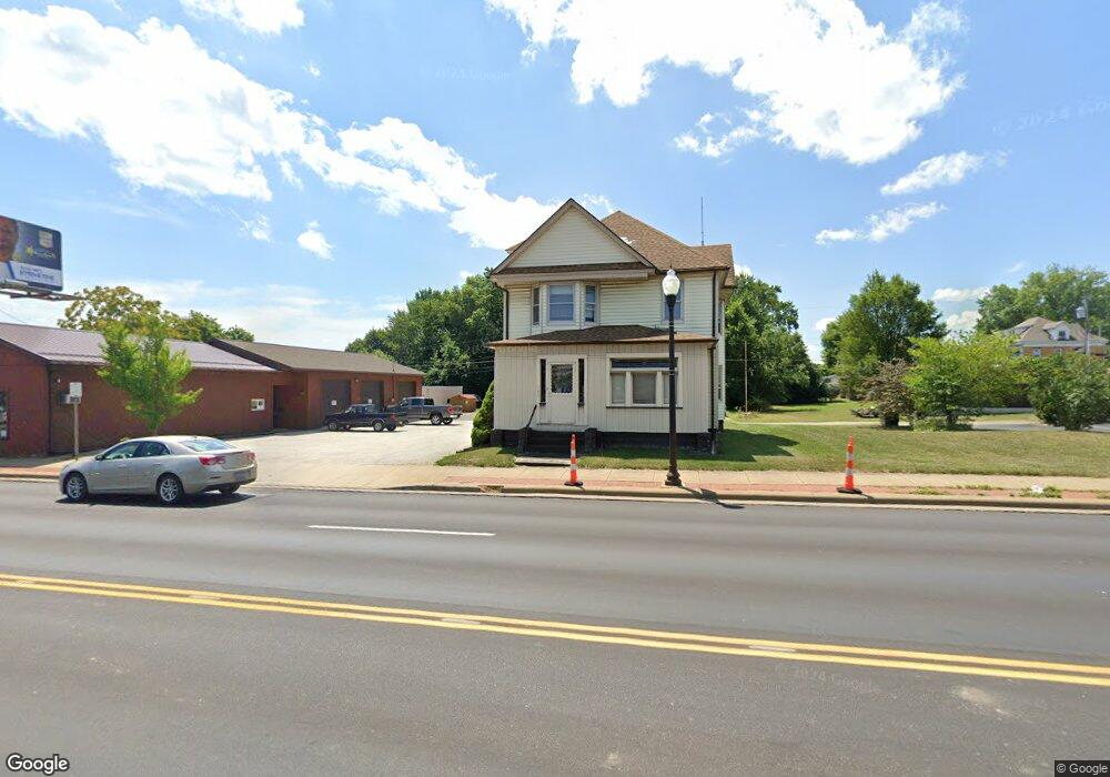
143 E State St Alliance, OH 44601
Estimated Value: $162,000 - $341,000
3
Beds
2
Baths
2,303
Sq Ft
$101/Sq Ft
Est. Value
About This Home
This home is located at 143 E State St, Alliance, OH 44601 and is currently estimated at $233,322, approximately $101 per square foot. 143 E State St is a home located in Stark County with nearby schools including Alliance Elementary School at Rockhill, Alliance Intermediate School at Northside, and Alliance Middle School.
Ownership History
Date
Name
Owned For
Owner Type
Purchase Details
Closed on
Dec 10, 2020
Sold by
Crewson Keith A and Crewson Susan B
Bought by
Joseph Asset Management Company Llc
Current Estimated Value
Purchase Details
Closed on
Nov 15, 2005
Sold by
Krannich Eleanor L and Krannich Eleanor
Bought by
Crewson Keith A and Crewson Susan B
Home Financials for this Owner
Home Financials are based on the most recent Mortgage that was taken out on this home.
Original Mortgage
$67,500
Interest Rate
6.04%
Mortgage Type
Purchase Money Mortgage
Purchase Details
Closed on
Nov 9, 2004
Sold by
Estate Of Fred B Krannich Sr
Bought by
Krannich Eleanor
Create a Home Valuation Report for This Property
The Home Valuation Report is an in-depth analysis detailing your home's value as well as a comparison with similar homes in the area
Home Values in the Area
Average Home Value in this Area
Purchase History
| Date | Buyer | Sale Price | Title Company |
|---|---|---|---|
| Joseph Asset Management Company Llc | $275,000 | None Available | |
| Crewson Keith A | $75,000 | Union Title Co | |
| Krannich Eleanor | -- | -- |
Source: Public Records
Mortgage History
| Date | Status | Borrower | Loan Amount |
|---|---|---|---|
| Previous Owner | Crewson Keith A | $67,500 |
Source: Public Records
Tax History
| Year | Tax Paid | Tax Assessment Tax Assessment Total Assessment is a certain percentage of the fair market value that is determined by local assessors to be the total taxable value of land and additions on the property. | Land | Improvement |
|---|---|---|---|---|
| 2025 | -- | $64,930 | $6,790 | $58,140 |
| 2024 | -- | $64,930 | $6,790 | $58,140 |
| 2023 | $2,300 | $43,400 | $5,810 | $37,590 |
| 2022 | $2,322 | $43,400 | $5,810 | $37,590 |
| 2021 | $2,559 | $43,400 | $5,810 | $37,590 |
| 2020 | $1,285 | $29,650 | $5,780 | $23,870 |
| 2019 | $1,267 | $29,650 | $5,780 | $23,870 |
Source: Public Records
Map
Nearby Homes
- 2041 Watson Ave
- 2117 Miller Ave
- 2372 S Union Ave
- 2405 Cherry Ave
- 2406 S Union Ave
- 390 E College St
- 2351 S Freedom Ave
- 2408 S Linden Ave
- 233 Shadyside Ct
- 224 Shadyside Ct
- 2364 Shunk Ave
- 1608 S Liberty Ave
- 555 E Milton St
- 834 Devine St
- 720 Vincent Blvd
- 2705 Shunk Ave
- 167 11th St
- 134 11th St
- 853 Fairway Dr
- 226 Milner St
- 135 E State St
- 127 E State St
- 119 E State St
- 103 E State St
- 2030 Cherry Ave
- 179 E State St
- 152 E Chestnut St
- 2050 Cherry Ave
- * E State St
- 2108 Cherry Ave
- 2029 Watson Ave
- 2051 Watson Ave
- 2045 Cherry Ave
- 2118 Cherry Ave
- 2105 Cherry Ave
- 2057 Watson Ave
- 33 E Chestnut St
- 2115 Watson Ave
- 2126 Cherry Ave
- 2115 Cherry Ave
Your Personal Tour Guide
Ask me questions while you tour the home.