Estimated Value: $302,272 - $417,000
5
Beds
2
Baths
2,258
Sq Ft
$159/Sq Ft
Est. Value
About This Home
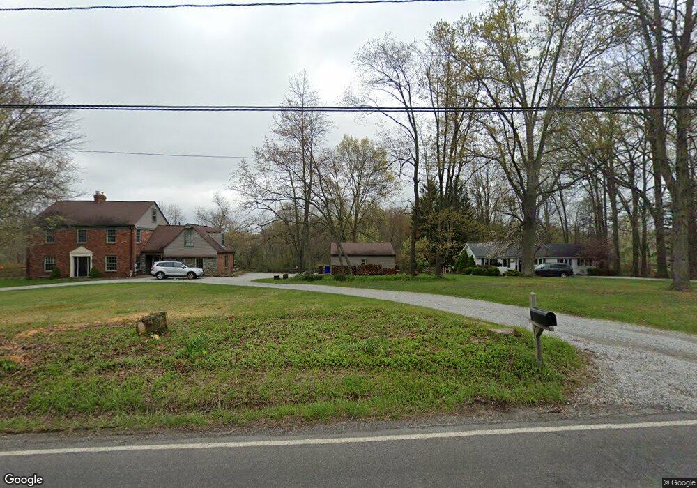
This home is located at 143 Howe Rd, Kent, OH 44240 and is currently estimated at $359,818, approximately $159 per square foot. 143 Howe Rd is a home located in Portage County with nearby schools including Brimfield Elementary School, Field Middle School, and Field High School.
Ownership History
Date
Name
Owned For
Owner Type
Purchase Details
Closed on
Jul 30, 2007
Sold by
Miller Dennis B and Miller Patricia Ann
Bought by
Montbach Timothy A and Montbach Erica N
Current Estimated Value
Home Financials for this Owner
Home Financials are based on the most recent Mortgage that was taken out on this home.
Original Mortgage
$195,200
Outstanding Balance
$120,767
Interest Rate
6.76%
Mortgage Type
Purchase Money Mortgage
Estimated Equity
$239,051
Purchase Details
Closed on
Jan 1, 1990
Bought by
Miller Dennis B
Create a Home Valuation Report for This Property
The Home Valuation Report is an in-depth analysis detailing your home's value as well as a comparison with similar homes in the area
Home Values in the Area
Average Home Value in this Area
Purchase History
| Date | Buyer | Sale Price | Title Company |
|---|---|---|---|
| Montbach Timothy A | $244,000 | Village Title Agency Inc | |
| Miller Dennis B | -- | -- |
Source: Public Records
Mortgage History
| Date | Status | Borrower | Loan Amount |
|---|---|---|---|
| Open | Montbach Timothy A | $195,200 |
Source: Public Records
Tax History
| Year | Tax Paid | Tax Assessment Tax Assessment Total Assessment is a certain percentage of the fair market value that is determined by local assessors to be the total taxable value of land and additions on the property. | Land | Improvement |
|---|---|---|---|---|
| 2025 | $4,406 | $91,180 | $14,000 | $77,180 |
| 2024 | $4,333 | $91,180 | $14,000 | $77,180 |
| 2023 | $4,428 | $75,110 | $8,750 | $66,360 |
| 2022 | $4,441 | $75,110 | $8,750 | $66,360 |
| 2021 | $4,333 | $75,110 | $8,750 | $66,360 |
| 2020 | $3,733 | $58,280 | $8,750 | $49,530 |
| 2019 | $3,682 | $58,280 | $8,750 | $49,530 |
| 2018 | $2,905 | $54,010 | $8,750 | $45,260 |
| 2017 | $2,905 | $54,010 | $8,750 | $45,260 |
| 2016 | $2,880 | $54,010 | $8,750 | $45,260 |
| 2015 | $2,783 | $54,010 | $8,750 | $45,260 |
| 2014 | $2,685 | $54,010 | $8,750 | $45,260 |
| 2013 | $2,622 | $54,010 | $8,750 | $45,260 |
Source: Public Records
Map
Nearby Homes
- 0 Progress Blvd Unit LotWP001
- 59 Tudor Ln
- 98 Benjamin Way
- 44 Benjamin Way
- 1079 Carol Ln
- 146 Reserve Dr
- 294 Milton Dr
- 0 Middlebury Rd
- 124 Tallmadge Rd
- 112 Tallmadge Rd
- 0 Northeast Ave Unit 5114314
- 1054 East Ave
- 895 East Ave
- 1138 Lower Dr
- 726 Hughey Dr
- 0 East Ave
- 528 E Howe Rd
- 99 N Munroe Rd
- 617 Northeast Ave
- 2477 Waterford Pointe Dr
Your Personal Tour Guide
Ask me questions while you tour the home.