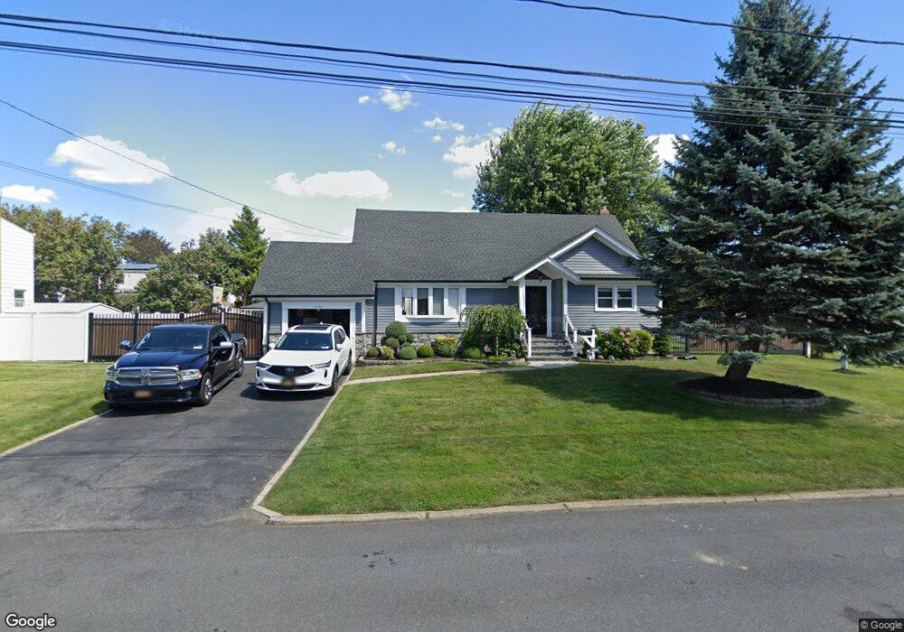
143 Suffolk Ave West Babylon, NY 11704
Estimated Value: $655,000 - $771,000
4
Beds
2
Baths
1,775
Sq Ft
$401/Sq Ft
Est. Value
About This Home
This home is located at 143 Suffolk Ave, West Babylon, NY 11704 and is currently estimated at $712,259, approximately $401 per square foot. 143 Suffolk Ave is a home located in Suffolk County with nearby schools including Robert Moses Middle School and North Babylon High School.
Ownership History
Date
Name
Owned For
Owner Type
Purchase Details
Closed on
Nov 14, 2018
Sold by
Brekka Jane A and Brekka Kenneth L
Bought by
Medina-Castro Carlos A and Medina Francisco A
Current Estimated Value
Home Financials for this Owner
Home Financials are based on the most recent Mortgage that was taken out on this home.
Original Mortgage
$368,065
Interest Rate
5.5%
Mortgage Type
FHA
Purchase Details
Closed on
Jan 27, 2004
Sold by
Brekka Nils J and Brekka Mildred M
Bought by
Brekka Jane A and Brekka Kenneth L
Create a Home Valuation Report for This Property
The Home Valuation Report is an in-depth analysis detailing your home's value as well as a comparison with similar homes in the area
Home Values in the Area
Average Home Value in this Area
Purchase History
| Date | Buyer | Sale Price | Title Company |
|---|---|---|---|
| Medina-Castro Carlos A | $375,000 | -- | |
| Brekka Jane A | -- | Columbia Title & Abstract |
Source: Public Records
Mortgage History
| Date | Status | Borrower | Loan Amount |
|---|---|---|---|
| Previous Owner | Medina-Castro Carlos A | $368,065 |
Source: Public Records
Tax History Compared to Growth
Tax History
| Year | Tax Paid | Tax Assessment Tax Assessment Total Assessment is a certain percentage of the fair market value that is determined by local assessors to be the total taxable value of land and additions on the property. | Land | Improvement |
|---|---|---|---|---|
| 2024 | $12,311 | $3,570 | $400 | $3,170 |
| 2023 | $12,311 | $3,570 | $400 | $3,170 |
| 2022 | $10,266 | $3,570 | $400 | $3,170 |
| 2021 | $10,266 | $3,570 | $400 | $3,170 |
| 2020 | $11,210 | $3,570 | $400 | $3,170 |
| 2019 | $11,210 | $0 | $0 | $0 |
| 2018 | $7,695 | $3,570 | $400 | $3,170 |
| 2017 | $7,695 | $3,570 | $400 | $3,170 |
| 2016 | $7,685 | $3,570 | $400 | $3,170 |
| 2015 | -- | $3,570 | $400 | $3,170 |
| 2014 | -- | $3,570 | $400 | $3,170 |
Source: Public Records
Map
Nearby Homes
- 135 Westchester Ave
- 652 Empire Ave
- 270 Fulton St
- 56 Suffolk Ave
- 155 Throop St
- 37 Seward St
- 545 Mount Ave
- 21 Silver St
- 1569 11th St
- 104 Essex St
- 340 Westchester Ave
- 170 Van Buren St
- 51 Columbia St
- 1558 9th St
- 17 Wright St
- 82 Schenectady Ave
- 57 Rockland Ave
- 214 Chelsea Ave
- 1203 Little East Neck Rd
- 325 Young St
- 151 Suffolk Ave
- 135 Suffolk Ave
- 144 Queens Ave
- 136 Queens Ave
- 152 Queens Ave
- 144 Suffolk Ave
- 136 Suffolk Ave
- 152 Suffolk Ave
- 127 Suffolk Ave
- 160 Queens Ave
- 128 Queens Ave
- 143 Nassau Ave
- 128 Suffolk Ave
- 160 Suffolk Ave
- 143 Queens Ave
- 135 Nassau Ave
- 151 Nassau Ave
- 135 Queens Ave
- 149 Queens Ave
- 167 Suffolk Ave