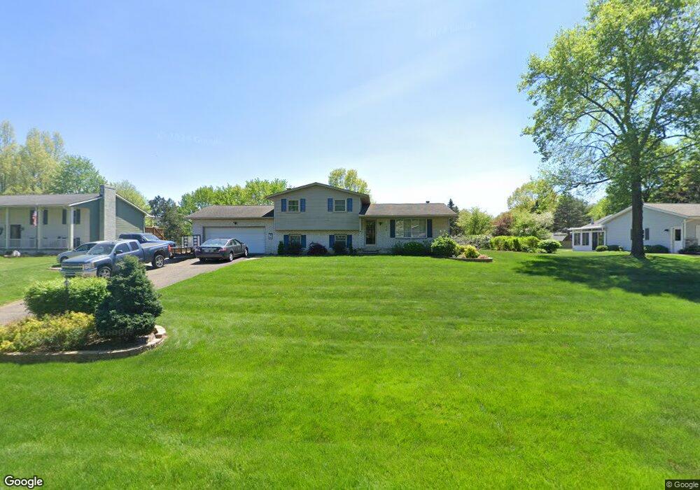
1430 Canyon St NE Uniontown, OH 44685
Estimated Value: $263,047 - $292,000
3
Beds
2
Baths
1,056
Sq Ft
$260/Sq Ft
Est. Value
About This Home
This home is located at 1430 Canyon St NE, Uniontown, OH 44685 and is currently estimated at $274,512, approximately $259 per square foot. 1430 Canyon St NE is a home located in Stark County with nearby schools including Lake Middle/High School and Lake Center Christian School.
Ownership History
Date
Name
Owned For
Owner Type
Purchase Details
Closed on
Sep 28, 2012
Sold by
Plaufcon Kimberly
Bought by
Phufean Scott
Current Estimated Value
Purchase Details
Closed on
Jun 26, 2003
Sold by
Zito Carol A
Bought by
Plaufcan Scott and Plaufcan Kimberly
Home Financials for this Owner
Home Financials are based on the most recent Mortgage that was taken out on this home.
Original Mortgage
$142,759
Interest Rate
5.51%
Mortgage Type
FHA
Purchase Details
Closed on
Aug 30, 1999
Sold by
Hall James V
Bought by
Zito Carol A
Home Financials for this Owner
Home Financials are based on the most recent Mortgage that was taken out on this home.
Original Mortgage
$103,600
Interest Rate
6.87%
Mortgage Type
Purchase Money Mortgage
Create a Home Valuation Report for This Property
The Home Valuation Report is an in-depth analysis detailing your home's value as well as a comparison with similar homes in the area
Home Values in the Area
Average Home Value in this Area
Purchase History
| Date | Buyer | Sale Price | Title Company |
|---|---|---|---|
| Phufean Scott | -- | None Available | |
| Phufean Scott | -- | None Available | |
| Plaufcan Scott | $145,000 | Real Living Title Agency Ltd | |
| Zito Carol A | $129,500 | Midland Title Security Inc |
Source: Public Records
Mortgage History
| Date | Status | Borrower | Loan Amount |
|---|---|---|---|
| Previous Owner | Plaufcan Scott | $142,759 | |
| Previous Owner | Zito Carol A | $103,600 |
Source: Public Records
Tax History Compared to Growth
Tax History
| Year | Tax Paid | Tax Assessment Tax Assessment Total Assessment is a certain percentage of the fair market value that is determined by local assessors to be the total taxable value of land and additions on the property. | Land | Improvement |
|---|---|---|---|---|
| 2025 | -- | $79,100 | $28,490 | $50,610 |
| 2024 | -- | $79,100 | $28,490 | $50,610 |
| 2023 | $3,010 | $64,510 | $17,780 | $46,730 |
| 2022 | $3,020 | $64,510 | $17,780 | $46,730 |
| 2021 | $3,054 | $64,510 | $17,780 | $46,730 |
| 2020 | $2,957 | $56,000 | $15,330 | $40,670 |
| 2019 | $2,930 | $56,000 | $15,330 | $40,670 |
| 2018 | $2,931 | $56,000 | $15,330 | $40,670 |
| 2017 | $2,721 | $48,300 | $15,330 | $32,970 |
| 2016 | $2,726 | $48,300 | $15,330 | $32,970 |
| 2015 | $2,724 | $48,300 | $15,330 | $32,970 |
| 2014 | $349 | $43,340 | $13,760 | $29,580 |
| 2013 | $1,175 | $43,340 | $13,760 | $29,580 |
Source: Public Records
Map
Nearby Homes
- 1037 Canyon St NE
- 11121 Geib Ave NE
- 2084 Hazel St NE
- 425 Tonawanda Trail SW
- 747 Grandview Cir
- 778 Fair Vista Cir SW
- 786 Fair Vista Cir SW
- 1180 Tessa Trail Unit 1180
- 11900 Geib Ave NE
- 550 Woodlands Glen Ave
- 531 Gentlebrook Blvd SW
- 525 Gentlebrook Blvd SW
- 225 Seneca Trail SW
- 510 Meadow Cir SW Unit 11
- 1975 Eloise Cir NE
- Unit 9 Meadow Trail SW Unit 9
- 12055 King Church Ave NW
- 330 Belle Ave SW
- 316 S Prospect Ave
- 12201 King Church Ave NW
- 1452 Canyon St NE
- 1404 Canyon St NE
- 1470 Canyon St NE
- 11096 Sagebrush Ave NE
- 11150 Sagebrush Ave NE
- 11114 Sagebrush Ave NE
- 11082 Sagebrush Ave NE
- 1433 Canyon St NE
- 1453 Canyon St NE
- 1488 Canyon St NE
- 1415 Canyon St NE
- 11074 Sagebrush Ave NE
- 1387 Canyon St NE
- 1471 Canyon St NE
- 11066 Sagebrush Ave NE
- 1489 Canyon St NE
- 1346 Canyon St NE
- 11216 Sagebrush Ave NE
- 11062 Sagebrush Ave NE
- 1509 Canyon St NE