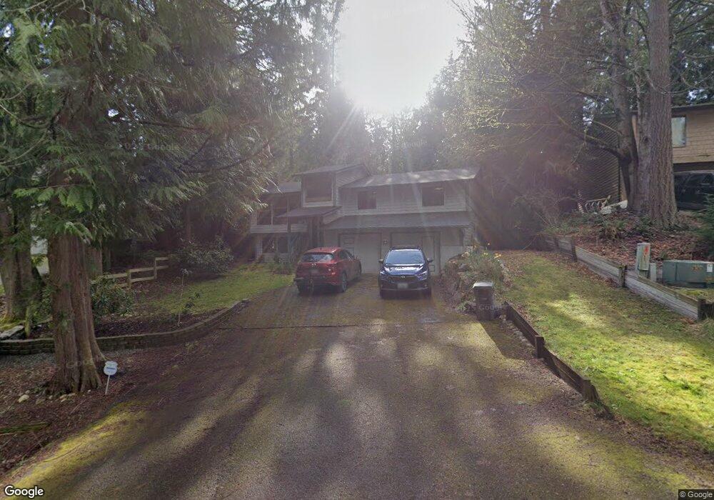
14302 61st Place W Edmonds, WA 98026
Estimated Value: $858,998 - $875,000
4
Beds
3
Baths
2,251
Sq Ft
$385/Sq Ft
Est. Value
About This Home
This home is located at 14302 61st Place W, Edmonds, WA 98026 and is currently estimated at $867,000, approximately $385 per square foot. 14302 61st Place W is a home located in Snohomish County with nearby schools including Picnic Point Elementary School, Harbour Pointe Middle School, and Kamiak High School.
Ownership History
Date
Name
Owned For
Owner Type
Purchase Details
Closed on
Jan 3, 2006
Sold by
Dudak Peter W
Bought by
Bansleben Erik P
Current Estimated Value
Home Financials for this Owner
Home Financials are based on the most recent Mortgage that was taken out on this home.
Original Mortgage
$222,350
Outstanding Balance
$124,978
Interest Rate
6.27%
Mortgage Type
Fannie Mae Freddie Mac
Estimated Equity
$742,022
Purchase Details
Closed on
Dec 3, 2001
Sold by
Dudak Catherine M
Bought by
Dudak Peter W
Create a Home Valuation Report for This Property
The Home Valuation Report is an in-depth analysis detailing your home's value as well as a comparison with similar homes in the area
Home Values in the Area
Average Home Value in this Area
Purchase History
| Date | Buyer | Sale Price | Title Company |
|---|---|---|---|
| Bansleben Erik P | $340,000 | Old Republic Title Ltd | |
| Dudak Peter W | -- | -- |
Source: Public Records
Mortgage History
| Date | Status | Borrower | Loan Amount |
|---|---|---|---|
| Open | Bansleben Erik P | $222,350 |
Source: Public Records
Tax History Compared to Growth
Tax History
| Year | Tax Paid | Tax Assessment Tax Assessment Total Assessment is a certain percentage of the fair market value that is determined by local assessors to be the total taxable value of land and additions on the property. | Land | Improvement |
|---|---|---|---|---|
| 2025 | $5,133 | $626,100 | $489,300 | $136,800 |
| 2024 | $5,133 | $602,400 | $465,600 | $136,800 |
| 2023 | $5,942 | $733,600 | $489,300 | $244,300 |
| 2022 | $5,086 | $529,300 | $319,000 | $210,300 |
| 2020 | $4,484 | $455,100 | $273,000 | $182,100 |
| 2019 | $4,217 | $429,400 | $251,000 | $178,400 |
| 2018 | $4,196 | $372,600 | $213,000 | $159,600 |
| 2017 | $3,775 | $342,700 | $197,000 | $145,700 |
| 2016 | $3,485 | $313,800 | $174,000 | $139,800 |
| 2015 | $3,608 | $297,900 | $161,000 | $136,900 |
| 2013 | $3,027 | $233,300 | $118,000 | $115,300 |
Source: Public Records
Map
Nearby Homes
- 6122 144th St SW
- 6306 141st St SW
- 6420 141st St SW
- 13802 60th Ave W
- 6520 146th St SW
- 6519 148th Place SW
- 13813 68th Ave W
- 6625 136th Place SW
- 14714 53rd Ave W Unit 116
- 14714 53rd Ave W Unit 119
- 14019 52nd Ave W Unit B
- 5015 144th St SW Unit B1
- 5015 144th St SW Unit A4
- 5015 144th St SW Unit B3
- 5015 144th St SW Unit C1
- 15424 61st Place W
- 5020 148th St SW Unit E1
- 5119 136th St SW
- 14224 Beverly Park Rd Unit A
- 4726 Picnic Point Rd
- 14226 61st Place W
- 14308 61st Place W
- 14218 61st Place W
- 14312 Salal Dr
- 6215 143rd St SW
- 14225 61st Place W
- 6217 143rd St SW
- 14316 Salal Dr
- 14219 61st Place W
- 14230 Salal Dr
- 14212 61st Place W
- 6219 143rd St SW
- 14211 61st Place W
- 6121 144th St SW
- 6212 143rd St SW
- 14206 61st Place W
- 6216 143rd St SW
- 14311 Salal Dr
- 14319 Salal Dr
- 6221 143rd St SW