
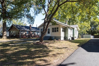
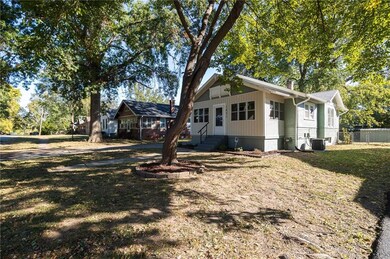
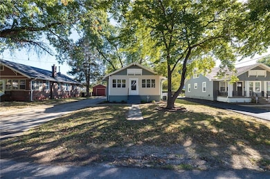
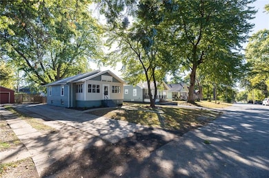
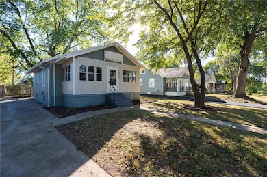
1431 S Ralston Ave Independence, MO 64052
Bristol NeighborhoodEstimated payment $1,060/month
Highlights
- No HOA
- Cooling Available
- Bungalow
About This Home
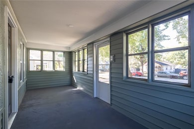
Come check out this lovely remodeled home in the heart of Independence! This one has been completely remodeled and is ready for you to move in and enjoy! All new exterior and interior paint along with all new flooring throughout the home! All new kitchen appliances, cabinets and countertops! New bathroom vanity and toilet along with all new light fixtures!
Listing Agent
Ruhlman Realty, LLC Brokerage Phone: 816-875-0253 License #2015014000 Listed on: 10/31/2025
Co-Listing Agent
Ruhlman Realty, LLC Brokerage Phone: 816-875-0253 License #2021007329
Home Details
Home Type
- Single Family
Est. Annual Taxes
- $691
Year Built
- Built in 1922
Lot Details
- 6,565 Sq Ft Lot
Parking
- Off-Street Parking
Home Design
- Bungalow
- Frame Construction
- Composition Roof
Interior Spaces
- 843 Sq Ft Home
- Unfinished Basement
- Basement Fills Entire Space Under The House
Bedrooms and Bathrooms
- 2 Bedrooms
- 1 Full Bathroom
Schools
- Van Horn High School
Utilities
- Cooling Available
- Heating System Uses Natural Gas
Community Details
- No Home Owners Association
- Maywood Continuation Subdivision
Listing and Financial Details
- Assessor Parcel Number 27-130-15-07-00-0-00-000
- $0 special tax assessment
Map
Home Values in the Area
Average Home Value in this Area
Tax History
| Year | Tax Paid | Tax Assessment Tax Assessment Total Assessment is a certain percentage of the fair market value that is determined by local assessors to be the total taxable value of land and additions on the property. | Land | Improvement |
|---|---|---|---|---|
| 2025 | $691 | $11,143 | $3,378 | $7,765 |
| 2024 | $1,008 | $9,690 | $1,617 | $8,073 |
| 2023 | $1,008 | $9,690 | $1,119 | $8,571 |
| 2022 | $666 | $8,740 | $2,347 | $6,393 |
| 2021 | $663 | $8,740 | $2,347 | $6,393 |
| 2020 | $644 | $8,263 | $2,347 | $5,916 |
| 2019 | $634 | $8,263 | $2,347 | $5,916 |
| 2018 | $641 | $8,109 | $1,344 | $6,765 |
| 2017 | $641 | $8,109 | $1,344 | $6,765 |
| 2016 | $640 | $7,907 | $1,566 | $6,341 |
| 2014 | $608 | $7,676 | $1,520 | $6,156 |
Property History
| Date | Event | Price | List to Sale | Price per Sq Ft |
|---|---|---|---|---|
| 10/31/2025 10/31/25 | For Sale | $189,900 | -- | $225 / Sq Ft |
Purchase History
| Date | Type | Sale Price | Title Company |
|---|---|---|---|
| Trustee Deed | $110,706 | None Listed On Document | |
| Personal Reps Deed | $34,500 | -- | |
| Quit Claim Deed | -- | -- |
Source: Heartland MLS
MLS Number: 2584683
APN: 27-130-15-07-00-0-00-000
Disclaimer: Certain information contained herein is derived from information provided by parties other than Homes.com. All information provided is deemed reliable, but is not guaranteed to be accurate and should be independently verified.
![]() Based on information submitted to the MLS GRID as of [see last changed date above]. All data is obtained from various sources and may not have been verified by broker or MLS GRID. Supplied Open House Information is subject to change without notice. All information should be independently reviewed and verified for accuracy. Properties may or may not be listed by the office/agent presenting the information. Some IDX listings have been excluded from this website. Prices displayed on all Sold listings are the Last Known Listing Price and may not be the actual selling price.
Based on information submitted to the MLS GRID as of [see last changed date above]. All data is obtained from various sources and may not have been verified by broker or MLS GRID. Supplied Open House Information is subject to change without notice. All information should be independently reviewed and verified for accuracy. Properties may or may not be listed by the office/agent presenting the information. Some IDX listings have been excluded from this website. Prices displayed on all Sold listings are the Last Known Listing Price and may not be the actual selling price.
Listing Information presented by local MLS brokerage: TEN-X, INC., local REALTOR®- Arlene Richardson - (888)952-6393
The Digital Millennium Copyright Act of 1998, 17 U.S.C. § 512 (the “DMCA”) provides recourse for copyright owners who believe that material appearing on the Internet infringes their rights under U.S. copyright law. If you believe in good faith that any content or material made available in connection with our website or services infringes your copyright, you (or your agent) may send us a notice requesting that the content or material be removed, or access to it blocked.
Notices must be sent in writing by email to DMCAnotice@MLSGrid.com.
The DMCA requires that your notice of alleged copyright infringement include the following information:
(1) description of the copyrighted work that is the subject of claimed infringement;
(2) description of the alleged infringing content and information sufficient to permit us to locate the content;
(3) contact information for you, including your address, telephone number and email address;
(4) a statement by you that you have a good faith belief that the content in the manner complained of is not authorized by the copyright owner, or its agent, or by the operation of any law;
(5) a statement by you, signed under penalty of perjury, that the information in the notification is accurate and that you have the authority to enforce the copyrights that are claimed to be infringed; and
(6) a physical or electronic signature of the copyright owner or a person authorized to act on the copyright owner’s behalf. Failure to include all of the above information may result in the delay of the processing of your complaint.
- 1433 S Ralston Ave
- 10709 E 13th St S
- 1416 S Hardy Ave
- 1420 S Appleton Ave
- 1610 S Northern Blvd
- 10901 E Truman Rd
- 1715 S Hardy Ave
- 1509 S Maywood Ave
- 10702 E Winner Rd
- 1612 S Harris Ave
- 10906 E Truman Rd
- 10617 E 18th Street S N A
- 11117 E 15th St S
- 1528 S Cedar Ave
- 1515 S Home Ave
- 1252 S Home Ave
- 1810 S Maywood Ave
- 909 S Appleton Ave
- 809 S Carlisle Ave
- 1103 S Crisp Ave
- 11308 E Aaron Ln Unit 11308
- 1906 S Willow Ave
- 11222 E 20th St S
- 9515 E 18 St S
- 1401 S Cunningham St
- 530 Sundown Dr
- 522 S Hardy Ave
- 1105 S Brookside Ave
- 1409-1415 W Maple Ave
- 525 Stone Arch Dr
- 10503 E Scarritt Ave
- 2624 S Evanston Ave
- 10513 E 28th Terrace S
- 1011 N Cottage St
- 1020 S Pleasant St Unit B
- 3302 S Sterling Ave
- 9611 E 33rd St S
- 120 W Elizabeth St
- 3405 S Oxford Ave Unit 3405 Oxford Ave
- 327 S Hocker Ave Unit R
