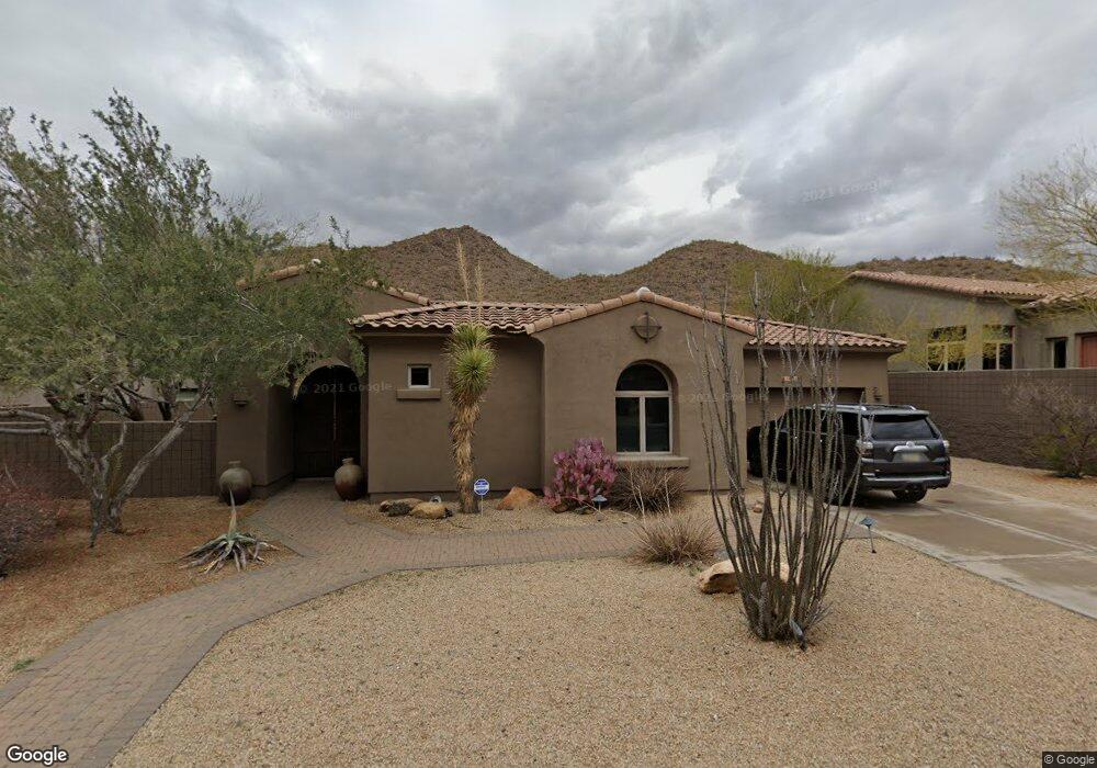
14316 E Geronimo Rd Scottsdale, AZ 85259
Estimated Value: $1,131,957 - $1,273,000
3
Beds
4
Baths
2,901
Sq Ft
$421/Sq Ft
Est. Value
About This Home
This home is located at 14316 E Geronimo Rd, Scottsdale, AZ 85259 and is currently estimated at $1,220,489, approximately $420 per square foot. 14316 E Geronimo Rd is a home located in Maricopa County with nearby schools including Anasazi Elementary School, Mountainside Middle School, and Desert Mountain High School.
Ownership History
Date
Name
Owned For
Owner Type
Purchase Details
Closed on
Oct 19, 2006
Sold by
Kirk Gerald R and Kirk Marilyn
Bought by
Kuzas Betsy
Current Estimated Value
Home Financials for this Owner
Home Financials are based on the most recent Mortgage that was taken out on this home.
Original Mortgage
$700,400
Outstanding Balance
$417,943
Interest Rate
6.46%
Mortgage Type
New Conventional
Estimated Equity
$802,546
Purchase Details
Closed on
Sep 11, 2001
Sold by
Golden Heritage Homes Inc
Bought by
Kirk Gerald R and Kirk Marilyn
Home Financials for this Owner
Home Financials are based on the most recent Mortgage that was taken out on this home.
Original Mortgage
$396,100
Interest Rate
7.37%
Create a Home Valuation Report for This Property
The Home Valuation Report is an in-depth analysis detailing your home's value as well as a comparison with similar homes in the area
Home Values in the Area
Average Home Value in this Area
Purchase History
| Date | Buyer | Sale Price | Title Company |
|---|---|---|---|
| Kuzas Betsy | $875,500 | Stewart Title & Trust Of Pho | |
| Kirk Gerald R | $455,889 | First American Title |
Source: Public Records
Mortgage History
| Date | Status | Borrower | Loan Amount |
|---|---|---|---|
| Open | Kuzas Betsy | $700,400 | |
| Previous Owner | Kirk Gerald R | $396,100 |
Source: Public Records
Tax History Compared to Growth
Tax History
| Year | Tax Paid | Tax Assessment Tax Assessment Total Assessment is a certain percentage of the fair market value that is determined by local assessors to be the total taxable value of land and additions on the property. | Land | Improvement |
|---|---|---|---|---|
| 2025 | $4,272 | $72,004 | -- | -- |
| 2024 | $4,216 | $68,576 | -- | -- |
| 2023 | $4,216 | $81,870 | $16,370 | $65,500 |
| 2022 | $4,713 | $62,200 | $12,440 | $49,760 |
| 2021 | $4,964 | $60,250 | $12,050 | $48,200 |
| 2020 | $4,941 | $58,000 | $11,600 | $46,400 |
| 2019 | $4,913 | $57,000 | $11,400 | $45,600 |
| 2018 | $4,834 | $54,860 | $10,970 | $43,890 |
| 2017 | $4,631 | $53,500 | $10,700 | $42,800 |
| 2016 | $4,562 | $53,100 | $10,620 | $42,480 |
| 2015 | $4,348 | $53,400 | $10,680 | $42,720 |
Source: Public Records
Map
Nearby Homes
- 14341 E Geronimo Rd
- 13647 N 143rd Place Unit 12
- 13723 N 143rd Place Unit 10
- 13672 N 143rd Place Unit 8
- 14296 E Kalil Dr
- 14371 E Kalil Dr
- 14152 E Kalil Dr Unit 26
- 14360 E Desert Cove Ave
- 12227 E Cholla Dr Unit 6
- 14402 E Wethersfield Rd Unit 1
- 14541 E Sierra Alegre Ct Unit 16
- 14253 E Desert Cove Ave Unit 2
- 14056 E Desert Cove Ave
- 13931 E Vía Linda
- 13990 E Coyote Rd Unit 11
- 14523 E Charter Oak Dr Unit 1
- 14699 E Paradise Dr Unit 26
- 14675 E Paradise Dr
- 14760 E Paradise Dr
- 11108 N Arista Ln Unit 20
- 14308 E Geronimo Rd
- 14324 E Geronimo Rd
- 14332 E Geronimo Rd
- 14300 E Geronimo Rd
- 14315 E Geronimo Rd
- 14321 E Geronimo Rd
- 14309 E Geronimo Rd
- 14340 E Geronimo Rd
- 14303 E Geronimo Rd
- 14292 E Geronimo Rd
- 14263 E Coyote Rd
- 14297 E Geronimo Rd
- 14333 E Geronimo Rd
- 14291 E Coyote Rd
- 14235 E Coyote Rd
- 14235 E Coyote Rd Unit 35
- 14348 E Geronimo Rd
- 14291 E Geronimo Rd
- 14211 E Coyote Rd Unit 66
- 14356 E Geronimo Rd