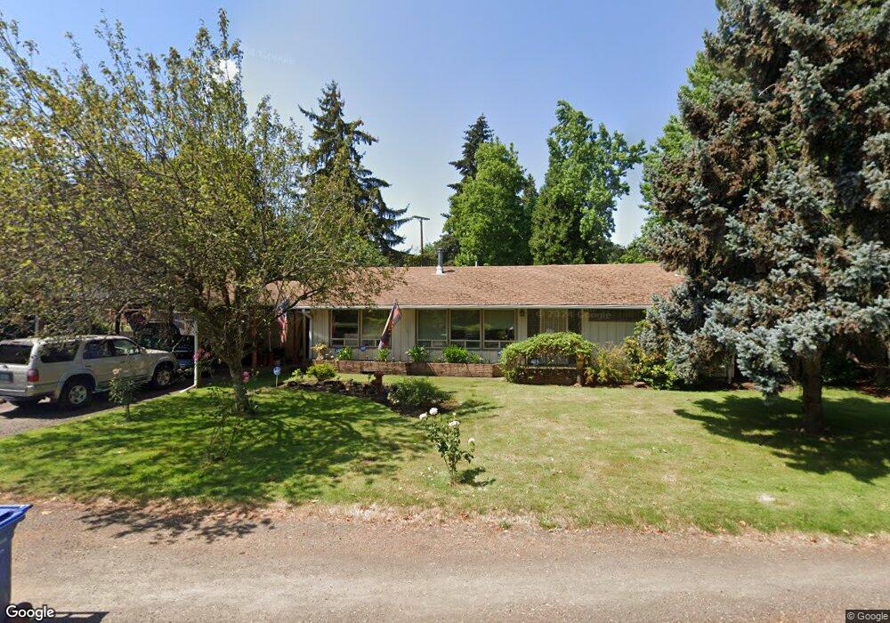
1432 Buck St Eugene, OR 97402
Churchill NeighborhoodEstimated Value: $531,000 - $560,000
About This Home
This home is located at 1432 Buck St, Eugene, OR 97402 and is currently estimated at $544,688, approximately $261 per square foot. 1432 Buck St is a home located in Lane County with nearby schools including McCornack Elementary School, Kennedy Middle School, and Churchill High School.
Ownership History
We collect this data history from publicly available records. To have your information removed, we recommend requesting removal directly through your county’s website.
Purchase Details
Purchase Details
Home Financials for this Owner
Home Financials are based on the most recent Mortgage that was taken out on this home.Purchase Details
Home Financials for this Owner
Home Financials are based on the most recent Mortgage that was taken out on this home.Home Values in the Area
Average Home Value in this Area
Purchase History
We collect this data history from publicly available records. To have your information removed, we recommend requesting removal directly through your county’s website.
| Date | Buyer | Sale Price | Title Company |
|---|---|---|---|
| -- | None Listed On Document | ||
| -- | Evergreen Land Title Company | ||
| $147,000 | Title Guaranty Company |
Mortgage History
We collect this data history from publicly available records. To have your information removed, we recommend requesting removal directly through your county’s website.
| Date | Status | Borrower | Loan Amount |
|---|---|---|---|
| Previous Owner | $91,500 | ||
| Previous Owner | $74,500 |
Tax History
We collect this data history from publicly available records. To have your information removed, we recommend requesting removal directly through your county’s website.
| Year | Tax Paid | Tax Assessment Tax Assessment Total Assessment is a certain percentage of the fair market value that is determined by local assessors to be the total taxable value of land and additions on the property. | Land | Improvement |
|---|---|---|---|---|
| 2025 | $6,093 | $312,740 | -- | -- |
| 2024 | $6,018 | $303,632 | -- | -- |
| 2023 | $6,018 | $294,789 | -- | -- |
| 2022 | $5,637 | $286,203 | $0 | $0 |
| 2021 | $5,295 | $277,867 | $0 | $0 |
| 2020 | $5,314 | $269,774 | $0 | $0 |
| 2019 | $5,132 | $261,917 | $0 | $0 |
| 2018 | $4,758 | $246,883 | $0 | $0 |
| 2017 | $4,396 | $246,883 | $0 | $0 |
| 2016 | $4,188 | $239,692 | $0 | $0 |
| 2015 | $3,996 | $232,711 | $0 | $0 |
| 2014 | $3,930 | $225,933 | $0 | $0 |
Map
- 3193 W 14th Ave
- 1438 Quaker St
- 1326 Quaker St
- 3063 W 15th Ave
- 3315 W 18th Ave
- 1812 Brittany St
- 0 W 18th Ave Unit LOT 2
- 0 W 18th Ave Unit LOT 3
- 2012 Greiner St
- 3648 Plumtree Dr
- 3659 W 18th Ave
- 2090 Hawkins Ln
- 2331 Todd St
- 3576 Westleigh St
- 2330 W 14th Ave
- 3389 Kevington Ave
- 2145 Hawkins Ln Unit 30
- 2200 Brittany St
- 2620 W 22nd Ave
- 1253 City View St
- 3262 W 14th Ave
- 3265 W 15th Ave
- 3180 W 14th Ave
- 1480 Buck St
- 3279 W 15th Ave
- 3274 W 14th Ave
- 1390 Buck St
- 3279 W 14th Ave
- 3289 W 15th Ave
- 3170 W 14th Ave
- 3179 W 14th Ave
- 3312 W 14th Ave
- 3293 W 14th Ave
- 1465 Buck St
- 1388 Buck St
- 1520 Buck St
- 3295 W 15th Ave
- 3190 W 13th Place
- 3150 W 14th Ave
- 3315 W 14th Ave
Ask me questions while you tour the home.