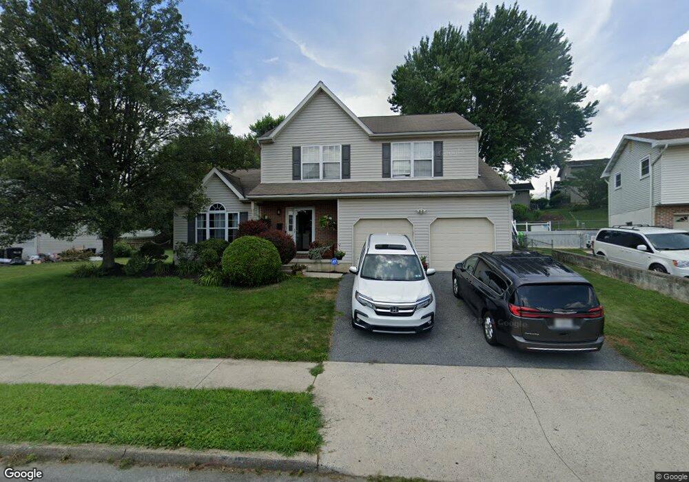
1432 Stanford Rd Bethlehem, PA 18018
West Bethlehem NeighborhoodEstimated Value: $434,000 - $474,000
3
Beds
3
Baths
1,940
Sq Ft
$234/Sq Ft
Est. Value
About This Home
This home is located at 1432 Stanford Rd, Bethlehem, PA 18018 and is currently estimated at $454,147, approximately $234 per square foot. 1432 Stanford Rd is a home located in Lehigh County with nearby schools including James Buchanan Elementary School, Nitschmann Middle School, and Liberty High School.
Ownership History
Date
Name
Owned For
Owner Type
Purchase Details
Closed on
Mar 11, 2005
Sold by
Nobles Kerry Maurice and Nobles Pauline
Bought by
Nobles Kerry Maurice and Nobles Pauline
Current Estimated Value
Create a Home Valuation Report for This Property
The Home Valuation Report is an in-depth analysis detailing your home's value as well as a comparison with similar homes in the area
Home Values in the Area
Average Home Value in this Area
Purchase History
| Date | Buyer | Sale Price | Title Company |
|---|---|---|---|
| Nobles Kerry Maurice | -- | -- |
Source: Public Records
Tax History Compared to Growth
Tax History
| Year | Tax Paid | Tax Assessment Tax Assessment Total Assessment is a certain percentage of the fair market value that is determined by local assessors to be the total taxable value of land and additions on the property. | Land | Improvement |
|---|---|---|---|---|
| 2025 | $6,775 | $235,800 | $37,500 | $198,300 |
| 2024 | $6,697 | $235,800 | $37,500 | $198,300 |
| 2023 | $6,638 | $235,800 | $37,500 | $198,300 |
| 2022 | $6,746 | $235,800 | $198,300 | $37,500 |
| 2021 | $6,716 | $235,800 | $37,500 | $198,300 |
| 2020 | $6,501 | $235,800 | $37,500 | $198,300 |
| 2019 | $6,548 | $235,800 | $37,500 | $198,300 |
| 2018 | $6,421 | $235,800 | $37,500 | $198,300 |
| 2017 | $6,136 | $235,800 | $37,500 | $198,300 |
| 2016 | -- | $235,800 | $37,500 | $198,300 |
| 2015 | -- | $235,800 | $37,500 | $198,300 |
| 2014 | -- | $235,800 | $37,500 | $198,300 |
Source: Public Records
Map
Nearby Homes
- 1541 Stanford Rd
- 1011 Highland Ave
- 934 Highland Ave
- 1334 W Union Blvd
- 1768 W Union Blvd
- 922 Beverly Ave
- 650 Highland Ave
- 1309 Greenview Dr
- 635 11th Ave
- 1512 W Broad St
- 1440 Greenview Dr
- 1336 Greenview Dr
- 1853 Richmond Ave
- 1247 Birchwood Dr
- 1559 Kelchner Rd
- 1209 Manchester Rd
- 531 9th Ave
- 1918 Pinehurst Rd
- 901 W Broad St
- 1198 Pennsylvania Ave
- 1426 Stanford Rd
- 0 Stanford Rd
- 1437 Dalehurst Dr
- 1431 Dalehurst Dr
- 1425 Dalehurst Dr
- 1458 Stanford Rd
- 1418 Stanford Rd
- 1449 Dalehurst Dr
- 1427 Stanford Rd
- 1435 Stanford Rd
- 1417 Dalehurst Dr
- 1459 Dalehurst Dr
- 1417 Stanford Rd
- 1441 Stanford Rd
- 1412 Stanford Rd
- 1411 Dalehurst Dr
- 1447 Stanford Rd
- 1438 Dalehurst Dr
- 1430 Dalehurst Dr
- 1329 Stanford Rd