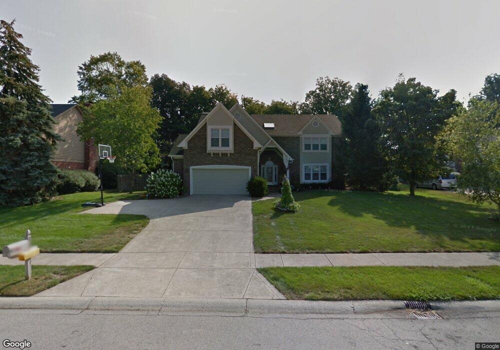
14321 Hawthorne Dr Carmel, IN 46033
East Carmel NeighborhoodEstimated Value: $529,000 - $551,739
4
Beds
3
Baths
3,581
Sq Ft
$152/Sq Ft
Est. Value
About This Home
This home is located at 14321 Hawthorne Dr, Carmel, IN 46033 and is currently estimated at $544,435, approximately $152 per square foot. 14321 Hawthorne Dr is a home located in Hamilton County with nearby schools including Cherry Tree Elementary School, Clay Middle School, and Carmel High School.
Ownership History
Date
Name
Owned For
Owner Type
Purchase Details
Closed on
May 13, 2016
Sold by
Hornsby Todd J
Bought by
Hornsby Todd J and Hornsby Tawnya R
Current Estimated Value
Purchase Details
Closed on
Apr 25, 2005
Sold by
Peragallo Louis A and Peragallo Karen F
Bought by
Hornsby Todd J
Home Financials for this Owner
Home Financials are based on the most recent Mortgage that was taken out on this home.
Original Mortgage
$219,600
Interest Rate
5.5%
Mortgage Type
Fannie Mae Freddie Mac
Create a Home Valuation Report for This Property
The Home Valuation Report is an in-depth analysis detailing your home's value as well as a comparison with similar homes in the area
Home Values in the Area
Average Home Value in this Area
Purchase History
| Date | Buyer | Sale Price | Title Company |
|---|---|---|---|
| Hornsby Todd J | -- | None Available | |
| Hornsby Todd J | -- | -- |
Source: Public Records
Mortgage History
| Date | Status | Borrower | Loan Amount |
|---|---|---|---|
| Previous Owner | Hornsby Todd J | $219,600 |
Source: Public Records
Tax History Compared to Growth
Tax History
| Year | Tax Paid | Tax Assessment Tax Assessment Total Assessment is a certain percentage of the fair market value that is determined by local assessors to be the total taxable value of land and additions on the property. | Land | Improvement |
|---|---|---|---|---|
| 2024 | $3,447 | $328,300 | $113,200 | $215,100 |
| 2023 | $3,472 | $328,300 | $113,200 | $215,100 |
| 2022 | $3,861 | $332,400 | $58,200 | $274,200 |
| 2021 | $3,598 | $311,200 | $58,200 | $253,000 |
| 2020 | $3,446 | $303,400 | $58,200 | $245,200 |
| 2019 | $3,347 | $294,800 | $56,200 | $238,600 |
| 2018 | $3,177 | $283,000 | $56,200 | $226,800 |
| 2017 | $3,047 | $274,200 | $56,200 | $218,000 |
| 2016 | $2,954 | $264,300 | $56,200 | $208,100 |
| 2014 | $2,799 | $264,100 | $56,200 | $207,900 |
| 2013 | $2,799 | $260,300 | $56,200 | $204,100 |
Source: Public Records
Map
Nearby Homes
- 1483 Spruce Dr
- 1504 Dorchester Place
- 781 Dayton Dr
- 1816 Spruce Dr
- 14554 Taylor Trace Dr
- 651 Hawthorne Dr
- 3172 Smokey Ridge Ln
- 1346 Smokey Row Ln
- 14011 Grisham Dr
- 14340 Sydney Ln
- 1910 Spruce Dr
- 2945 Millgate Dr
- 13615 Smokey Hollow Place
- 2913 Twain Dr
- 14610 Village Park Dr E
- 4323 Short Terrace
- 14737 Setters Rd
- 4655 Allen Dr
- 14901 Windmill Dr
- 1983 Woodbine Ct
- 14349 Hawthorne Dr
- 1433 Queensborough Dr
- 14291 Hawthorne Dr
- 1437 Queensborough Dr
- 1429 Queensborough Dr
- 14332 Hawthorne Dr
- 3590 Hawthorne Dr W
- 14375 Hawthorne Dr
- 1441 Queensborough Dr
- 14360 Hawthorne Dr
- 3625 Hawthorne Dr W
- 14388 Hawthorne Dr
- 1425 Queensborough Dr
- 1445 Queensborough Dr
- 14407 Hawthorne Dr
- 3558 Hawthorne Dr W
- 1445 Queensborough D
- 1434 Queensborough Dr
- 3583 Hawthorne Dr W
- 1438 Queensborough Dr