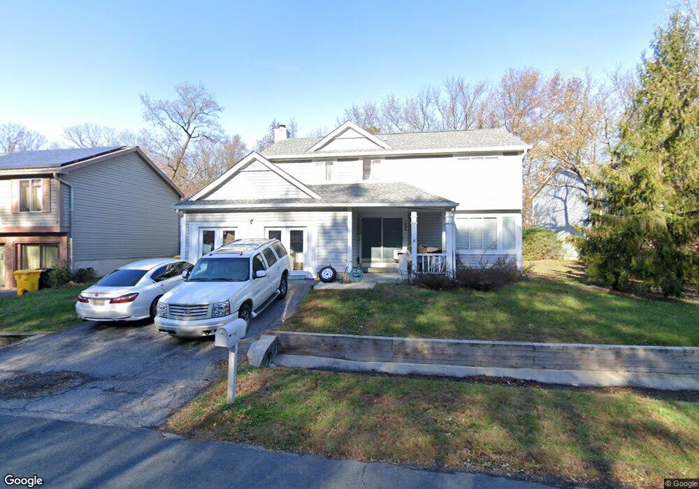
1434 Wisp Ct Hanover, MD 21076
Estimated Value: $505,000 - $522,000
--
Bed
3
Baths
1,934
Sq Ft
$264/Sq Ft
Est. Value
About This Home
This home is located at 1434 Wisp Ct, Hanover, MD 21076 and is currently estimated at $511,343, approximately $264 per square foot. 1434 Wisp Ct is a home located in Anne Arundel County with nearby schools including Hebron-Harman Elementary School, MacArthur Middle School, and Meade High School.
Ownership History
Date
Name
Owned For
Owner Type
Purchase Details
Closed on
May 5, 2004
Sold by
Reynolds Robert O
Bought by
Reyes Nelson N and Reyes Iris M
Current Estimated Value
Purchase Details
Closed on
Aug 29, 1995
Sold by
Moreland Richard F
Bought by
Reynolds Robert O
Home Financials for this Owner
Home Financials are based on the most recent Mortgage that was taken out on this home.
Original Mortgage
$135,675
Interest Rate
7.32%
Purchase Details
Closed on
Jun 26, 1987
Sold by
Harmans
Bought by
Moreland Richard F
Home Financials for this Owner
Home Financials are based on the most recent Mortgage that was taken out on this home.
Original Mortgage
$115,900
Interest Rate
10.35%
Create a Home Valuation Report for This Property
The Home Valuation Report is an in-depth analysis detailing your home's value as well as a comparison with similar homes in the area
Home Values in the Area
Average Home Value in this Area
Purchase History
| Date | Buyer | Sale Price | Title Company |
|---|---|---|---|
| Reyes Nelson N | $289,900 | -- | |
| Reynolds Robert O | $149,000 | -- | |
| Moreland Richard F | $122,500 | -- |
Source: Public Records
Mortgage History
| Date | Status | Borrower | Loan Amount |
|---|---|---|---|
| Previous Owner | Reynolds Robert O | $135,675 | |
| Previous Owner | Moreland Richard F | $115,900 | |
| Closed | Reyes Nelson N | -- |
Source: Public Records
Tax History Compared to Growth
Tax History
| Year | Tax Paid | Tax Assessment Tax Assessment Total Assessment is a certain percentage of the fair market value that is determined by local assessors to be the total taxable value of land and additions on the property. | Land | Improvement |
|---|---|---|---|---|
| 2025 | $4,747 | $403,000 | $197,000 | $206,000 |
| 2024 | $4,747 | $387,633 | $0 | $0 |
| 2023 | $4,539 | $372,267 | $0 | $0 |
| 2022 | $4,160 | $356,900 | $177,000 | $179,900 |
| 2021 | $8,058 | $344,367 | $0 | $0 |
| 2020 | $3,858 | $331,833 | $0 | $0 |
| 2019 | $3,730 | $319,300 | $145,400 | $173,900 |
| 2018 | $3,186 | $314,233 | $0 | $0 |
| 2017 | $3,533 | $309,167 | $0 | $0 |
| 2016 | -- | $304,100 | $0 | $0 |
| 2015 | -- | $304,100 | $0 | $0 |
| 2014 | -- | $304,100 | $0 | $0 |
Source: Public Records
Map
Nearby Homes
- 1434 Fairbanks Dr
- 1454 Graham Farm Cir
- 7684 Tuckerman Dr
- 1464 Gesna Dr
- 1703 Long Tree Ct
- 1610 Taylor Terrace
- 1212 Scattered Pines Ct
- 1630 Hekla Ln
- 7714 Sentry Terrace
- 7716 Sentry Terrace
- 7911 Red Globe Ct
- 7963 Heather Mist Dr
- 7726 Aragorn Ct
- 7954 Heather Mist Dr
- 1550 Provincial Ln
- 1308 Sewell Farm Dr
- 203 Mill Crossing Ct
- 7701 Argonaut St
- 207 Otis Dr
- 1734 Sea Pine Cir Unit 136