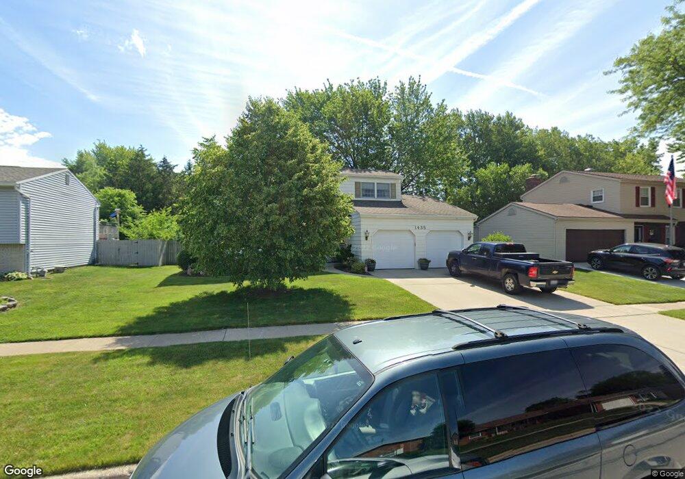
1435 Forrester Dr Oregon, OH 43616
Estimated Value: $263,000 - $289,000
4
Beds
2
Baths
1,740
Sq Ft
$157/Sq Ft
Est. Value
About This Home
This home is located at 1435 Forrester Dr, Oregon, OH 43616 and is currently estimated at $273,616, approximately $157 per square foot. 1435 Forrester Dr is a home located in Lucas County with nearby schools including St. Kateri Catholic Schools and First St. John Day School.
Ownership History
Date
Name
Owned For
Owner Type
Purchase Details
Closed on
Feb 8, 2002
Sold by
Fox Angela E and Rollins Christine Anne
Bought by
Swanson Michael T and Swanson Teresa A
Current Estimated Value
Purchase Details
Closed on
Oct 30, 1998
Sold by
Cousino Edward L and Cousino Kathleen M
Bought by
Swanson Michael T and Swanson Teresa A
Home Financials for this Owner
Home Financials are based on the most recent Mortgage that was taken out on this home.
Original Mortgage
$114,000
Interest Rate
6.78%
Create a Home Valuation Report for This Property
The Home Valuation Report is an in-depth analysis detailing your home's value as well as a comparison with similar homes in the area
Home Values in the Area
Average Home Value in this Area
Purchase History
| Date | Buyer | Sale Price | Title Company |
|---|---|---|---|
| Swanson Michael T | $800 | -- | |
| Swanson Michael T | $2,300 | -- | |
| Swanson Michael T | $135,000 | -- |
Source: Public Records
Mortgage History
| Date | Status | Borrower | Loan Amount |
|---|---|---|---|
| Previous Owner | Swanson Michael T | $114,000 |
Source: Public Records
Tax History Compared to Growth
Tax History
| Year | Tax Paid | Tax Assessment Tax Assessment Total Assessment is a certain percentage of the fair market value that is determined by local assessors to be the total taxable value of land and additions on the property. | Land | Improvement |
|---|---|---|---|---|
| 2024 | $2,059 | $86,625 | $14,105 | $72,520 |
| 2023 | $3,281 | $58,660 | $10,430 | $48,230 |
| 2022 | $3,305 | $58,660 | $10,430 | $48,230 |
| 2021 | $3,331 | $58,660 | $10,430 | $48,230 |
| 2020 | $3,285 | $51,415 | $9,100 | $42,315 |
| 2019 | $3,192 | $51,415 | $9,100 | $42,315 |
| 2018 | $3,121 | $51,415 | $9,100 | $42,315 |
| 2017 | $3,123 | $47,145 | $10,185 | $36,960 |
| 2016 | $3,083 | $134,700 | $29,100 | $105,600 |
| 2015 | $3,063 | $134,700 | $29,100 | $105,600 |
| 2014 | $2,816 | $46,210 | $9,980 | $36,230 |
| 2013 | $2,816 | $46,210 | $9,980 | $36,230 |
Source: Public Records
Map
Nearby Homes
- 1339 Eastmeadow Dr
- 3216 Brown Rd
- 1937 S Coy Rd
- 1927 Bordeaux Rue
- Sweet Pea Plan at Oregon Town Center - Aspire at Oregon Town Center
- 3023 Nautical Ln
- 1946 Terri Rue
- 0 Lemoyne Rd
- 1826 Bieber Dr
- 127 Lemoyne Rd
- 29 Lemoyne Rd
- 123 Lemoyne Rd
- 3904 Oakfield Dr
- 0 Curtice Rd
- 1126 Heritage Ln
- 1102 Heritage Ln
- 3736 Navarre Ave
- 2432 Brown Rd
- 3860 Navarre Ave
- 1450 S Lallendorf Rd
- 1429 Forrester Dr
- 1441 Forrester Dr
- 1423 Forrester Dr
- 1447 Forrester Dr
- 1417 Forester Dr
- 1453 Forrester Dr
- 1417 Forrester Dr
- 1407 Forrester Dr
- 1436 Forrester Dr
- 1430 Forester Dr
- 1442 Forrester Dr
- 1413 Forrester Dr
- 1430 Forrester Dr
- 1448 Forrester Dr
- 1505 Forrester Dr
- 1424 Forrester Dr
- 1454 Forrester Dr
- 1418 Forrester Dr
- 1401 Forrester Dr
- 1511 Forrester Dr