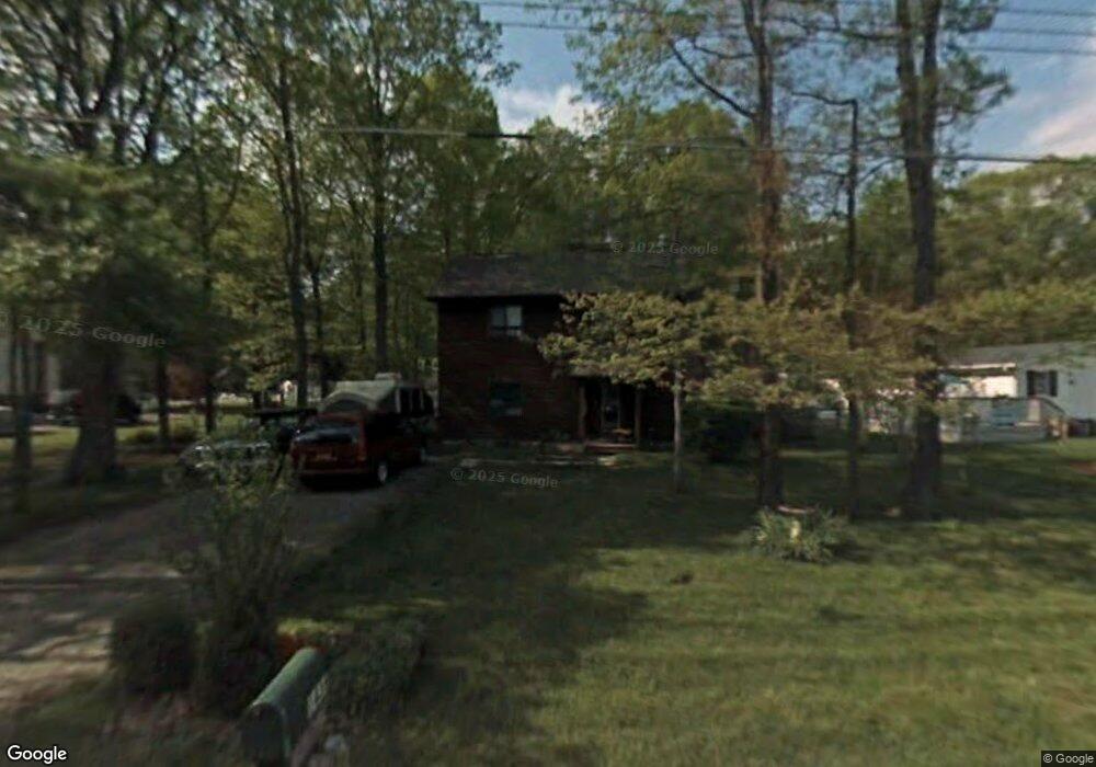
1436 Cedarhurst Rd Shady Side, MD 20764
Estimated Value: $407,220 - $465,000
--
Bed
2
Baths
1,880
Sq Ft
$237/Sq Ft
Est. Value
About This Home
This home is located at 1436 Cedarhurst Rd, Shady Side, MD 20764 and is currently estimated at $444,805, approximately $236 per square foot. 1436 Cedarhurst Rd is a home located in Anne Arundel County with nearby schools including Shady Side Elementary School, Southern Middle School, and Southern High School.
Ownership History
Date
Name
Owned For
Owner Type
Purchase Details
Closed on
Aug 11, 2023
Sold by
Donnelly Timothy H
Bought by
Donnelly Timothy H
Current Estimated Value
Purchase Details
Closed on
Apr 9, 1992
Sold by
Swans Ltd Ptnshp
Bought by
Donnelly Timothy H and Donnelly Tina L
Home Financials for this Owner
Home Financials are based on the most recent Mortgage that was taken out on this home.
Original Mortgage
$125,400
Interest Rate
8.96%
Purchase Details
Closed on
Dec 14, 1989
Sold by
Ruff Frank
Bought by
Swans Ltd Ptnshp
Home Financials for this Owner
Home Financials are based on the most recent Mortgage that was taken out on this home.
Original Mortgage
$128,000
Interest Rate
9.76%
Create a Home Valuation Report for This Property
The Home Valuation Report is an in-depth analysis detailing your home's value as well as a comparison with similar homes in the area
Home Values in the Area
Average Home Value in this Area
Purchase History
| Date | Buyer | Sale Price | Title Company |
|---|---|---|---|
| Donnelly Timothy H | -- | Brennan Title | |
| Donnelly Timothy H | -- | Brennan Title | |
| Donnelly Timothy H | $132,000 | -- | |
| Swans Ltd Ptnshp | $29,000 | -- |
Source: Public Records
Mortgage History
| Date | Status | Borrower | Loan Amount |
|---|---|---|---|
| Previous Owner | Donnelly Timothy H | $125,400 | |
| Previous Owner | Swans Ltd Ptnshp | $128,000 |
Source: Public Records
Tax History Compared to Growth
Tax History
| Year | Tax Paid | Tax Assessment Tax Assessment Total Assessment is a certain percentage of the fair market value that is determined by local assessors to be the total taxable value of land and additions on the property. | Land | Improvement |
|---|---|---|---|---|
| 2025 | $3,114 | $351,700 | -- | -- |
| 2024 | $3,114 | $329,300 | $0 | $0 |
| 2023 | $3,009 | $306,900 | $135,000 | $171,900 |
| 2022 | $2,813 | $301,100 | $0 | $0 |
| 2021 | $5,533 | $295,300 | $0 | $0 |
| 2020 | $2,680 | $289,500 | $135,000 | $154,500 |
| 2019 | $2,636 | $282,800 | $0 | $0 |
| 2018 | $2,800 | $276,100 | $0 | $0 |
| 2017 | $2,486 | $269,400 | $0 | $0 |
| 2016 | -- | $269,367 | $0 | $0 |
| 2015 | -- | $269,333 | $0 | $0 |
| 2014 | -- | $269,300 | $0 | $0 |
Source: Public Records
Map
Nearby Homes
- 1436 Haile Pkwy
- 0 Haile Pkwy Unit MDAA2127474
- 1445 & 1447 Haile Pkwy
- 1461 Cedarhurst Rd
- 0 Shady Side Rd Unit MDAA2113156
- 0 Shady Side Rd Unit MDAA2113166
- 1428 Haile Pkwy
- 1408 & 1410 Haile Pkwy
- 6070 Shady Side Rd
- 6118 Shady Side Rd
- 6152 Shady Side Rd
- 1419 Shady Rest Rd
- 1208 Oak Ave
- 1213 Oak Ave
- 1302 Spruce St
- 1220 Grove Ave
- 4949 Idlewilde Rd
- 1512 Lincoln Rd
- 4913 Chestnut St
- 4950 W End Ave
- 1434 Cedarhurst Rd
- 1442 Cedarhurst Rd
- 1448 Cedarhurst Rd
- 1437 Cedarhurst Rd
- 1447 Cedarhurst Rd
- 1441 Cedarhurst Rd
- 1428 Cedarhurst Rd
- 1451 Cedarhurst Rd
- 1432 Cedarhurst Rd
- 1426 Cedarhurst Rd
- 1431 Cedarhurst Rd
- 1422 Cedarhurst Rd
- 1427 Cedarhurst Rd
- 1416 Cedarhurst Rd
- 1459 Cedarhurst Rd
- 1417 Cedarhurst Rd
- 1466 Cedarhurst Rd
- 1434 Heile Pkwy
- 1410 Cedarhurst Rd
- 1411 Cedarhurst Rd