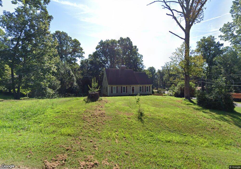
144 Corn Tassel Trail Stoneville, NC 27048
Estimated Value: $335,000 - $430,000
3
Beds
2
Baths
2,565
Sq Ft
$143/Sq Ft
Est. Value
About This Home
This home is located at 144 Corn Tassel Trail, Stoneville, NC 27048 and is currently estimated at $366,348, approximately $142 per square foot. 144 Corn Tassel Trail is a home located in Rockingham County with nearby schools including Douglass Elementary School, J.E. Holmes Middle School, and John M. Morehead High School.
Ownership History
Date
Name
Owned For
Owner Type
Purchase Details
Closed on
Apr 16, 2018
Sold by
Reo Aquisition Llc
Bought by
Rook Robert M and Rook Tamara Norris
Current Estimated Value
Home Financials for this Owner
Home Financials are based on the most recent Mortgage that was taken out on this home.
Original Mortgage
$112,500
Outstanding Balance
$96,590
Interest Rate
4.37%
Mortgage Type
Adjustable Rate Mortgage/ARM
Estimated Equity
$269,758
Purchase Details
Closed on
Feb 9, 2018
Sold by
Christian Trust
Bought by
Reo Acquistion I Llc
Purchase Details
Closed on
Jan 11, 2018
Sold by
Christian Trust
Bought by
Reo Acquistion I Llc
Purchase Details
Closed on
Jul 20, 2017
Sold by
Rhodes Brian D and Rhodes Pamela B
Bought by
Christiana Trust and Wilmington Savings Fund Society
Create a Home Valuation Report for This Property
The Home Valuation Report is an in-depth analysis detailing your home's value as well as a comparison with similar homes in the area
Home Values in the Area
Average Home Value in this Area
Purchase History
| Date | Buyer | Sale Price | Title Company |
|---|---|---|---|
| Rook Robert M | $125,000 | None Available | |
| Reo Acquistion I Llc | -- | None Available | |
| Reo Acquistion I Llc | -- | None Available | |
| Christiana Trust | $166,000 | None Available |
Source: Public Records
Mortgage History
| Date | Status | Borrower | Loan Amount |
|---|---|---|---|
| Open | Rook Robert M | $112,500 |
Source: Public Records
Tax History Compared to Growth
Tax History
| Year | Tax Paid | Tax Assessment Tax Assessment Total Assessment is a certain percentage of the fair market value that is determined by local assessors to be the total taxable value of land and additions on the property. | Land | Improvement |
|---|---|---|---|---|
| 2025 | $2,387 | $361,543 | $17,976 | $343,567 |
| 2024 | $2,349 | $361,543 | $17,976 | $343,567 |
| 2023 | $2,349 | $195,780 | $16,777 | $179,003 |
| 2022 | $1,556 | $195,780 | $16,777 | $179,003 |
| 2021 | $1,556 | $195,780 | $16,777 | $179,003 |
| 2020 | $1,556 | $195,780 | $16,777 | $179,003 |
| 2019 | $1,543 | $194,030 | $16,777 | $177,253 |
| 2018 | $1,551 | $194,852 | $24,777 | $170,075 |
| 2017 | $1,551 | $194,852 | $24,777 | $170,075 |
| 2015 | $1,567 | $194,852 | $24,777 | $170,075 |
| 2014 | -- | $194,852 | $24,777 | $170,075 |
Source: Public Records
Map
Nearby Homes
- 144 Corn Tassell Trail
- 132 Corn Tassell Trail
- 171 Nevermore Dr
- 194 Nevermore Dr
- 120 Corn Tassell Trail
- 145 Corn Tassell Trail
- 174 Nevermore Dr
- 133 Corn Tassell Trail
- 173 Corn Tassell Trail
- 164 Nevermore Dr
- 121 Corn Tassell Trail
- 106 Corn Tassell Trail
- 111 Corn Tassell Trail
- 170 Corn Tassell Trail
- 193 Corn Tassell Trail
- 154 Nevermore Dr
- 630 Eden Rd
- 142 Nevermore Dr
- 142 Nevermore Dr
- 620 Eden Rd