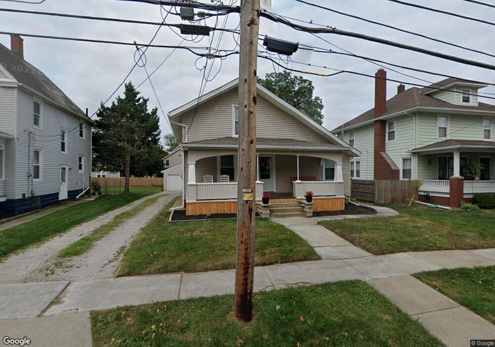
144 Forest St Amherst, OH 44001
Estimated Value: $203,000 - $240,523
4
Beds
2
Baths
1,587
Sq Ft
$139/Sq Ft
Est. Value
About This Home
This home is located at 144 Forest St, Amherst, OH 44001 and is currently estimated at $220,381, approximately $138 per square foot. 144 Forest St is a home located in Lorain County with nearby schools including Powers Elementary School, Walter G. Nord Middle School, and Amherst Junior High School.
Ownership History
Date
Name
Owned For
Owner Type
Purchase Details
Closed on
Dec 3, 2021
Sold by
Hembree Cody A and Hembree Kara
Bought by
Clapper Steven J
Current Estimated Value
Home Financials for this Owner
Home Financials are based on the most recent Mortgage that was taken out on this home.
Original Mortgage
$206,196
Outstanding Balance
$189,595
Interest Rate
3.09%
Mortgage Type
FHA
Estimated Equity
$30,786
Purchase Details
Closed on
Nov 4, 2019
Sold by
M49 Capital Llc
Bought by
Hembree Cody A and Irvin Kara
Home Financials for this Owner
Home Financials are based on the most recent Mortgage that was taken out on this home.
Original Mortgage
$135,850
Interest Rate
3.7%
Mortgage Type
New Conventional
Purchase Details
Closed on
Dec 27, 2012
Sold by
Wohlever Lawrence J and Wohlever Paul D
Bought by
M49 Capital Llc
Create a Home Valuation Report for This Property
The Home Valuation Report is an in-depth analysis detailing your home's value as well as a comparison with similar homes in the area
Home Values in the Area
Average Home Value in this Area
Purchase History
| Date | Buyer | Sale Price | Title Company |
|---|---|---|---|
| Clapper Steven J | $210,000 | None Available | |
| Hembree Cody A | $143,000 | Accommodation | |
| M49 Capital Llc | $28,500 | American Patriot Title Agenc |
Source: Public Records
Mortgage History
| Date | Status | Borrower | Loan Amount |
|---|---|---|---|
| Open | Clapper Steven J | $206,196 | |
| Previous Owner | Hembree Cody A | $135,850 |
Source: Public Records
Tax History Compared to Growth
Tax History
| Year | Tax Paid | Tax Assessment Tax Assessment Total Assessment is a certain percentage of the fair market value that is determined by local assessors to be the total taxable value of land and additions on the property. | Land | Improvement |
|---|---|---|---|---|
| 2024 | $2,367 | $58,608 | $9,321 | $49,287 |
| 2023 | $2,126 | $44,377 | $8,729 | $35,648 |
| 2022 | $2,038 | $44,377 | $8,729 | $35,648 |
| 2021 | $2,044 | $44,377 | $8,729 | $35,648 |
| 2020 | $1,888 | $36,390 | $7,400 | $28,990 |
| 2019 | $1,900 | $36,390 | $7,400 | $28,990 |
| 2018 | $1,711 | $36,390 | $7,400 | $28,990 |
| 2017 | $1,513 | $27,070 | $6,280 | $20,790 |
| 2016 | $1,526 | $27,070 | $6,280 | $20,790 |
| 2015 | $1,519 | $27,070 | $6,280 | $20,790 |
| 2014 | $1,400 | $24,840 | $5,760 | $19,080 |
| 2013 | $1,405 | $24,840 | $5,760 | $19,080 |
Source: Public Records
Map
Nearby Homes
- 2176 Myla Way
- 2180 Myla Way
- 891 Park Ave
- 825 Cleveland Ave
- 168 Orchard Hill Dr
- 105 N Woodhill Dr
- 483 N Main St
- 1140 Woodside Dr
- 394 Long St
- 726 Sunrise Dr
- 0 Stonebridge Dr
- 707 Greenlawn Dr
- 653 Brennan Dr
- 135 Ridgeland Dr
- 117 Fall Lake Ln
- 621 Van Oaks Dr
- 0 Middle Ridge Rd Unit 5160578
- 0 Middle Ridge Rd Unit 5102632
- 748 Tarry Ln
- V/L Middle Ridge Rd