Estimated Value: $872,000
--
Bed
--
Bath
1,760
Sq Ft
$495/Sq Ft
Est. Value
About This Home
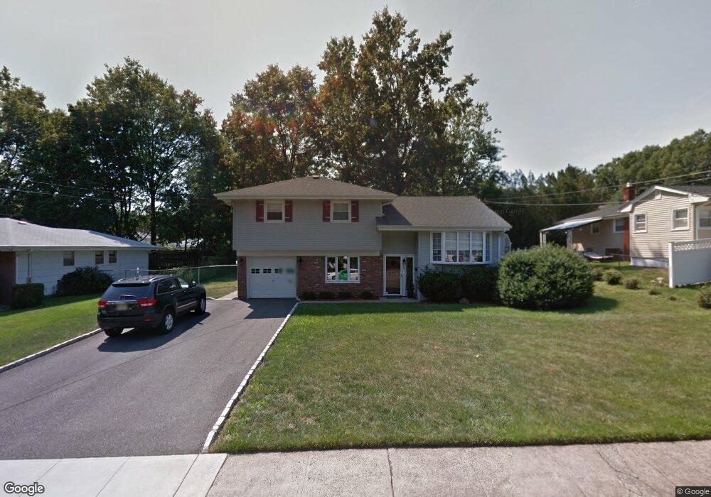
This home is located at 144 Hayes Ave, Clark, NJ 07066 and is currently estimated at $872,000, approximately $495 per square foot. 144 Hayes Ave is a home located in Union County with nearby schools including Frank K. Hehnly Elementary School, Carl H. Kumpf Middle School, and Arthur L. Johnson High School.
Ownership History
Date
Name
Owned For
Owner Type
Purchase Details
Closed on
Feb 22, 2013
Current Estimated Value
Home Financials for this Owner
Home Financials are based on the most recent Mortgage that was taken out on this home.
Original Mortgage
$435,030
Outstanding Balance
$303,547
Interest Rate
3.37%
Mortgage Type
FHA
Estimated Equity
$568,453
Purchase Details
Closed on
Jun 11, 2010
Sold by
Polinger Kurt Alexander and Polinger Jennifer V
Home Financials for this Owner
Home Financials are based on the most recent Mortgage that was taken out on this home.
Original Mortgage
$441,849
Interest Rate
5.12%
Mortgage Type
FHA
Create a Home Valuation Report for This Property
The Home Valuation Report is an in-depth analysis detailing your home's value as well as a comparison with similar homes in the area
Home Values in the Area
Average Home Value in this Area
Purchase History
| Date | Buyer | Sale Price | Title Company |
|---|---|---|---|
| -- | -- | None Available | |
| -- | $450,000 | Acres Land Title Agency Llc |
Source: Public Records
Mortgage History
| Date | Status | Borrower | Loan Amount |
|---|---|---|---|
| Open | -- | $435,030 | |
| Closed | -- | $441,849 |
Source: Public Records
Tax History Compared to Growth
Tax History
| Year | Tax Paid | Tax Assessment Tax Assessment Total Assessment is a certain percentage of the fair market value that is determined by local assessors to be the total taxable value of land and additions on the property. | Land | Improvement |
|---|---|---|---|---|
| 2025 | $10,539 | $476,000 | $258,500 | $217,500 |
| 2024 | $10,382 | $476,000 | $258,500 | $217,500 |
| 2023 | $10,382 | $476,000 | $258,500 | $217,500 |
| 2022 | $10,082 | $476,000 | $258,500 | $217,500 |
| 2021 | $10,997 | $123,700 | $47,000 | $76,700 |
| 2020 | $10,818 | $123,700 | $47,000 | $76,700 |
| 2019 | $10,709 | $123,700 | $47,000 | $76,700 |
| 2018 | $10,580 | $123,700 | $47,000 | $76,700 |
| 2017 | $10,411 | $123,700 | $47,000 | $76,700 |
| 2016 | $10,027 | $123,700 | $47,000 | $76,700 |
| 2015 | $9,926 | $123,700 | $47,000 | $76,700 |
| 2014 | $9,717 | $123,700 | $47,000 | $76,700 |
Source: Public Records
Map
Nearby Homes
- 44 Post Rd
- 39 Mildred Terrace
- 44 Shetland Dr
- 112 Patricia Ave
- 442 Stalevicz Ln
- 77 Conduit Way
- 205 Patricia Ave
- 47 Dewitt Terrace
- 992 Milton Blvd
- 71 Skyline Dr
- 24 Savoy St
- 789 Hillside Rd
- 1228 Mayfair Dr
- 1169 Briarcliff Dr
- 150 Carolyn Ave
- 1101 Plymouth Dr
- 58 Gertrude St
- 1081 Madison Hill Rd
- 11 Dufoe Place
- 122 Berthold Ave