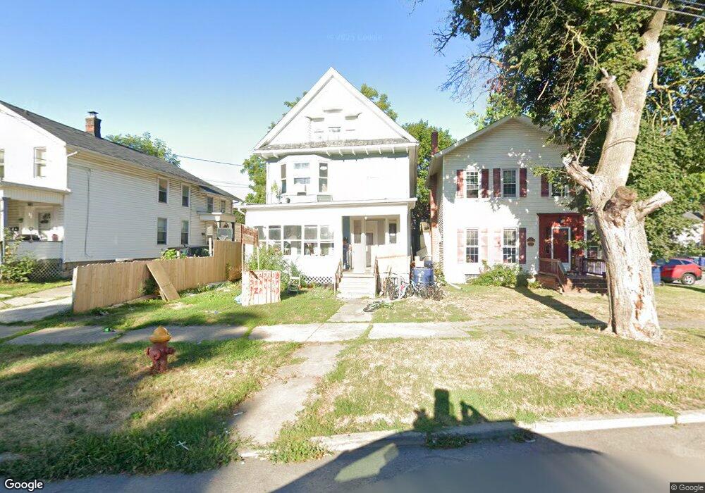
144 Locust St Lockport, NY 14094
Estimated Value: $117,000 - $168,087
6
Beds
2
Baths
2,424
Sq Ft
$57/Sq Ft
Est. Value
About This Home
This home is located at 144 Locust St, Lockport, NY 14094 and is currently estimated at $139,272, approximately $57 per square foot. 144 Locust St is a home located in Niagara County with nearby schools including Aaron Mossell Junior High School, Lockport High School, and DeSales Catholic School.
Ownership History
Date
Name
Owned For
Owner Type
Purchase Details
Closed on
May 14, 2012
Sold by
Lewis Patrick
Bought by
Lindemuth Robert
Current Estimated Value
Purchase Details
Closed on
Mar 26, 2012
Sold by
Haynes Michael
Bought by
Lewis Patrick
Purchase Details
Closed on
Nov 30, 2007
Sold by
Dunn Timothy
Bought by
Haynes Michael
Home Financials for this Owner
Home Financials are based on the most recent Mortgage that was taken out on this home.
Original Mortgage
$50,000
Interest Rate
13.75%
Mortgage Type
Unknown
Purchase Details
Closed on
Feb 22, 2005
Sold by
Donner Scott
Bought by
Dunn Timothy
Create a Home Valuation Report for This Property
The Home Valuation Report is an in-depth analysis detailing your home's value as well as a comparison with similar homes in the area
Home Values in the Area
Average Home Value in this Area
Purchase History
| Date | Buyer | Sale Price | Title Company |
|---|---|---|---|
| Lindemuth Robert | $37,000 | -- | |
| Lewis Patrick | $68,964 | Ryan Mills | |
| Haynes Michael | $45,500 | Richard May | |
| Dunn Timothy | $33,000 | Bruce Ikefugi |
Source: Public Records
Mortgage History
| Date | Status | Borrower | Loan Amount |
|---|---|---|---|
| Previous Owner | Haynes Michael | $50,000 |
Source: Public Records
Tax History Compared to Growth
Tax History
| Year | Tax Paid | Tax Assessment Tax Assessment Total Assessment is a certain percentage of the fair market value that is determined by local assessors to be the total taxable value of land and additions on the property. | Land | Improvement |
|---|---|---|---|---|
| 2024 | $3,103 | $117,000 | $1,100 | $115,900 |
| 2023 | $3,103 | $111,000 | $1,100 | $109,900 |
| 2022 | $2,241 | $101,000 | $1,100 | $99,900 |
| 2021 | $1,648 | $41,800 | $1,100 | $40,700 |
| 2020 | $1,613 | $41,800 | $1,100 | $40,700 |
| 2019 | $361 | $41,800 | $1,100 | $40,700 |
| 2018 | $1,166 | $41,800 | $1,100 | $40,700 |
| 2017 | $1,162 | $41,800 | $1,100 | $40,700 |
| 2016 | $1,125 | $41,800 | $1,100 | $40,700 |
| 2015 | -- | $41,800 | $1,100 | $40,700 |
| 2014 | -- | $41,800 | $1,100 | $40,700 |
Source: Public Records
Map
Nearby Homes
- 38 Park Place
- 222 High St
- 177 Genesee St
- 227 Genesee St
- 135 Pine St
- 274 Washburn St
- 275 Genesee St
- 271 Locust St
- 104 Cottage St
- 107 Spalding St
- 111 Spalding St
- 192 Cottage St
- 123 Spalding St
- 275 Pine St
- 411 Washburn St
- 137 Spalding St
- Wilshier Plan at Lincoln Woods
- Bentley Plan at Lincoln Woods
- Kensington Plan at Lincoln Woods
- Grayson Plan at Lincoln Woods