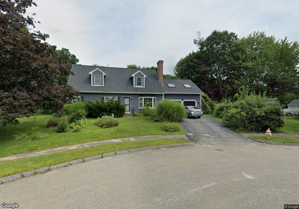
144 Paugus Rd Holden, MA 01520
Estimated Value: $578,193 - $681,000
4
Beds
3
Baths
2,211
Sq Ft
$276/Sq Ft
Est. Value
About This Home
This home is located at 144 Paugus Rd, Holden, MA 01520 and is currently estimated at $609,548, approximately $275 per square foot. 144 Paugus Rd is a home located in Worcester County with nearby schools including Wachusett Regional High School, Abby Kelley Foster Charter Public School, and Bancroft School.
Ownership History
Date
Name
Owned For
Owner Type
Purchase Details
Closed on
Oct 30, 2001
Sold by
Hammar John C
Bought by
Austin Nancy E
Current Estimated Value
Home Financials for this Owner
Home Financials are based on the most recent Mortgage that was taken out on this home.
Original Mortgage
$30,000
Interest Rate
6.67%
Create a Home Valuation Report for This Property
The Home Valuation Report is an in-depth analysis detailing your home's value as well as a comparison with similar homes in the area
Home Values in the Area
Average Home Value in this Area
Purchase History
| Date | Buyer | Sale Price | Title Company |
|---|---|---|---|
| Austin Nancy E | $80,000 | -- |
Source: Public Records
Mortgage History
| Date | Status | Borrower | Loan Amount |
|---|---|---|---|
| Open | Austin Nancy E | $78,000 | |
| Closed | Austin Nancy E | $30,000 | |
| Closed | Austin Nancy E | $70,000 | |
| Previous Owner | Austin Nancy E | $30,000 |
Source: Public Records
Tax History
| Year | Tax Paid | Tax Assessment Tax Assessment Total Assessment is a certain percentage of the fair market value that is determined by local assessors to be the total taxable value of land and additions on the property. | Land | Improvement |
|---|---|---|---|---|
| 2025 | $6,660 | $480,500 | $159,300 | $321,200 |
| 2024 | $6,648 | $469,800 | $154,600 | $315,200 |
| 2023 | $6,267 | $418,100 | $134,400 | $283,700 |
| 2022 | $6,333 | $382,400 | $105,000 | $277,400 |
| 2021 | $6,130 | $352,300 | $100,000 | $252,300 |
| 2020 | $5,874 | $345,500 | $95,300 | $250,200 |
| 2019 | $5,479 | $314,000 | $95,300 | $218,700 |
| 2018 | $5,343 | $303,400 | $90,700 | $212,700 |
| 2017 | $4,943 | $281,000 | $90,700 | $190,300 |
| 2016 | $4,632 | $268,500 | $86,400 | $182,100 |
| 2015 | $4,718 | $260,400 | $86,400 | $174,000 |
| 2014 | $4,622 | $260,400 | $86,400 | $174,000 |
Source: Public Records
Map
Nearby Homes
- 140 Paugus Rd
- 145 Paugus Rd
- 8 Frederickson Ave
- 10 Heritage Ln
- 10 Frederickson Ave
- 16 Heritage Ln
- 141 Paugus Rd
- 134 Paugus Rd
- 339 Holden St
- 135 Paugus Rd
- 14 Frederickson Ave
- 22 Heritage Ln
- 16 Frederickson Ave
- 5 Frederickson Ave
- 122 Paugus Rd
- 360 Holden St
- 350 Holden St
- 227 Holden St
- 13 Frederickson Ave
- 344 Holden St
Your Personal Tour Guide
Ask me questions while you tour the home.