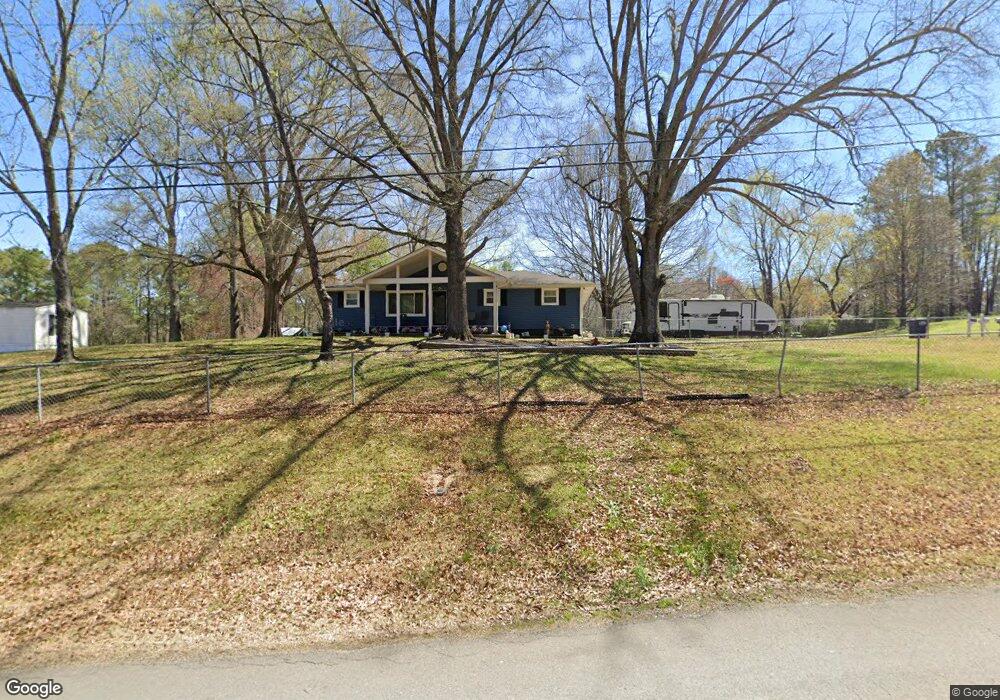
1441 S Michael Dr Tunnel Hill, GA 30755
Estimated Value: $74,000 - $236,000
--
Bed
1
Bath
1,560
Sq Ft
$107/Sq Ft
Est. Value
About This Home
This home is located at 1441 S Michael Dr, Tunnel Hill, GA 30755 and is currently estimated at $166,433, approximately $106 per square foot. 1441 S Michael Dr is a home located in Whitfield County with nearby schools including Westside Elementary School, Westside Middle School, and Northwest Whitfield County High School.
Ownership History
Date
Name
Owned For
Owner Type
Purchase Details
Closed on
Oct 14, 2015
Sold by
Stanley Melissa C
Bought by
Stanley Sterling O and Stanley Melissa C
Current Estimated Value
Home Financials for this Owner
Home Financials are based on the most recent Mortgage that was taken out on this home.
Original Mortgage
$71,200
Outstanding Balance
$28,940
Interest Rate
3.93%
Mortgage Type
New Conventional
Estimated Equity
$137,493
Purchase Details
Closed on
Sep 25, 2001
Sold by
Jones Warren D and Jones Melissa C
Bought by
Stanley Melissa C
Purchase Details
Closed on
May 1, 1994
Bought by
Jones Warren D and Jones Melissa C
Create a Home Valuation Report for This Property
The Home Valuation Report is an in-depth analysis detailing your home's value as well as a comparison with similar homes in the area
Home Values in the Area
Average Home Value in this Area
Purchase History
| Date | Buyer | Sale Price | Title Company |
|---|---|---|---|
| Stanley Sterling O | -- | -- | |
| Stanley Melissa C | -- | -- | |
| Jones Warren D | $61,000 | -- |
Source: Public Records
Mortgage History
| Date | Status | Borrower | Loan Amount |
|---|---|---|---|
| Open | Stanley Sterling O | $71,200 |
Source: Public Records
Tax History Compared to Growth
Tax History
| Year | Tax Paid | Tax Assessment Tax Assessment Total Assessment is a certain percentage of the fair market value that is determined by local assessors to be the total taxable value of land and additions on the property. | Land | Improvement |
|---|---|---|---|---|
| 2024 | $2,230 | $88,871 | $8,400 | $80,471 |
| 2023 | $1,525 | $60,274 | $5,250 | $55,024 |
| 2022 | $1,055 | $44,318 | $5,250 | $39,068 |
| 2021 | $1,084 | $45,279 | $5,250 | $40,029 |
| 2020 | $1,109 | $45,279 | $5,250 | $40,029 |
| 2019 | $921 | $38,824 | $5,250 | $33,574 |
| 2018 | $931 | $38,824 | $5,250 | $33,574 |
| 2017 | $931 | $38,824 | $5,250 | $33,574 |
| 2016 | $749 | $33,585 | $2,992 | $30,593 |
| 2014 | $766 | $35,843 | $5,250 | $30,593 |
| 2013 | -- | $35,842 | $5,250 | $30,592 |
Source: Public Records
Map
Nearby Homes
- 321 Whitmire Cir
- 140 Ault Dr
- 200 England Dr
- 163 Gladstone Way
- 130 Jocelyn Way
- 359 Lafayette Rd
- 1105 Mcclure Dr
- 3038 Chattanooga Rd
- 674 Shadow Leaf Ln
- 1127 Mount Vernon Rd
- 1113 Mount Vernon Rd
- Lot 2 Hillside Dr
- 638 Pine Oaks Dr
- 1098 Mount Vernon Rd
- 3231 Leona Dr
- 250 Pinnacle Pointe Dr Unit 22
- 3218 Leona Dr
- 00 Chattanooga Rd
- 4579 Dogwood Valley Rd
- 616 Pine Oaks Dr
- 1404 Pamela Dr
- 1431 S Michael Dr
- 1414 Pamela Dr
- 1414 Pamela Dr
- 1442 S Michael Dr
- 1434 S Michael Dr
- 701 Vernon Dr
- 1501 Pamela Dr
- 706 Vernon Dr
- 717 Vernon Dr
- 708 Vernon Dr
- 1421 S Michael Dr
- 1515 Pamela Dr
- 1420 S Michael Dr
- 706 Vernon Dr
- 716 Vernon Dr
- 653 Houston Valley Rd
- 669 Houston Valley Rd
- 1410 S Michael Dr
- 726 Vernon Dr