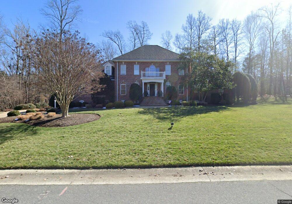
14419 Lander Rd Midlothian, VA 23113
Westchester NeighborhoodEstimated Value: $1,174,139 - $1,287,000
6
Beds
4
Baths
5,165
Sq Ft
$241/Sq Ft
Est. Value
About This Home
This home is located at 14419 Lander Rd, Midlothian, VA 23113 and is currently estimated at $1,244,046, approximately $240 per square foot. 14419 Lander Rd is a home located in Chesterfield County with nearby schools including Bettie Weaver Elementary School, Midlothian Middle School, and Midlothian High School.
Ownership History
Date
Name
Owned For
Owner Type
Purchase Details
Closed on
Jul 25, 2001
Sold by
Constructi M Jarrelle Jr
Bought by
Reese Richard S and Reese Anne H
Current Estimated Value
Home Financials for this Owner
Home Financials are based on the most recent Mortgage that was taken out on this home.
Original Mortgage
$400,000
Outstanding Balance
$154,598
Interest Rate
7.18%
Mortgage Type
New Conventional
Estimated Equity
$1,089,448
Create a Home Valuation Report for This Property
The Home Valuation Report is an in-depth analysis detailing your home's value as well as a comparison with similar homes in the area
Home Values in the Area
Average Home Value in this Area
Purchase History
| Date | Buyer | Sale Price | Title Company |
|---|---|---|---|
| Reese Richard S | $605,000 | -- |
Source: Public Records
Mortgage History
| Date | Status | Borrower | Loan Amount |
|---|---|---|---|
| Open | Reese Richard S | $400,000 |
Source: Public Records
Tax History
| Year | Tax Paid | Tax Assessment Tax Assessment Total Assessment is a certain percentage of the fair market value that is determined by local assessors to be the total taxable value of land and additions on the property. | Land | Improvement |
|---|---|---|---|---|
| 2025 | $8,955 | $1,003,400 | $170,000 | $833,400 |
| 2024 | $8,955 | $1,009,700 | $149,000 | $860,700 |
| 2023 | $7,821 | $859,500 | $144,000 | $715,500 |
| 2022 | $7,470 | $812,000 | $134,000 | $678,000 |
| 2021 | $6,473 | $674,400 | $132,000 | $542,400 |
| 2020 | $6,834 | $719,400 | $132,000 | $587,400 |
| 2019 | $6,522 | $686,500 | $130,000 | $556,500 |
| 2018 | $6,522 | $686,500 | $130,000 | $556,500 |
| 2017 | $6,590 | $686,500 | $130,000 | $556,500 |
| 2016 | $6,590 | $686,500 | $130,000 | $556,500 |
| 2015 | $6,615 | $686,500 | $130,000 | $556,500 |
| 2014 | $6,248 | $648,200 | $118,000 | $530,200 |
Source: Public Records
Map
Nearby Homes
- 14335 Lander Rd
- 2213 Founders Bridge Rd
- 16151 Founders Bridge Terrace
- 536 Totten Dr
- 2121 Christendom Dr
- 16021 Aspect Way
- 16025 Aspect Way
- 16029 Aspect Way
- 16033 Aspect Way
- 16037 Aspect Way
- 16041 Aspect Way
- 16120 Esteem Way
- 16108 Esteem Way
- 16108 Esteem Way Unit AA 54
- 16104 Esteem Way
- 16112 Esteem Way Unit AA 53
- 16112 Esteem Way
- 16116 Esteem Way
- 0005 Flying Cloud Aly Unit 7-2
- 533 Creekwillow Dr
- 2512 Kettlewell Ct
- 2600 Witton Turn
- 2506 Kettlewell Ct
- 2519 Kettlewell Ct
- 14412 Lander Rd
- 2606 Witton Turn
- 2601 Witton Turn
- 2507 Lander Ct
- 14507 Lander Rd
- 2501 Lander Ct
- 2500 Kettlewell Ct
- 14406 Lander Rd
- 2507 Kettlewell Ct
- 2501 Kettlewell Ct
- 2612 Witton Turn
- 2500 Lander Ct
- 14513 Lander Rd
- 14400 Lander Rd
- 14600 Lander Rd
- 2524 Follensbee Dr
Your Personal Tour Guide
Ask me questions while you tour the home.