NOT LISTED FOR SALE

1444 Jeff Dr Manning, SC 29102

Estimated Value: $32,000 - $117,000

4.2 Acres
$15,635 Price per Acre
182,952 Sq Ft Lot

Last Sold December 29, 2017

Last sale price $21,000 $15 Per Sq Ft

Est. 213% increase in value since last sale

Current estimated payment $402/month

77 Days on Market

About This Lot

As of December 2017

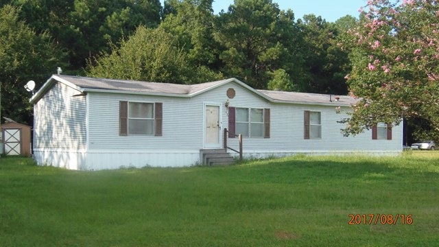
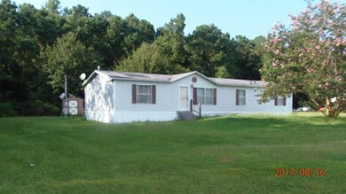
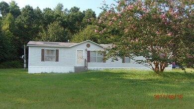
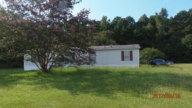
1444 JEFF RD - $20,800 - LAND ONLY ****** LAND ONLY ****** Land has 4.2 acres. Being sold as is where is. Employees and family members residing with employees of JPMorgan Chase Bank, N.A, its affiliates or subsidiaries are strictly prohibited from directly or indirectly purchasing any property owned by JPMorgan Chase Bank, N.A. SUBMIT OFFERS TO - http://www.spsreo.com/?c=AGQK

Last Listed By

Kenya Harris

Personal Touch Realty, LLC Brokerage Phone: 8037743000 License #53857 Listed on: 09/13/2017

Property Details

Property Type

  • Land

Est. Annual Taxes

  • $458

Year Built

  • 1997

Lot Details

  • 4.2 Acre Lot
  • Dirt Road
  • Rural Setting
  • Cleared Lot

Mobile Home

Utilities

  • Septic Tank

Community Details

  • No Home Owners Association
  • Jordan Section Ii Subdivision

Listing and Financial Details

  • Assessor Parcel Number 164000306400

Property Details

Property Type

Land

Est. Annual Taxes

$458

Year Built

1997

Lot Details

0

Listing Details

  • Attribution Contact: 8037743000
  • Directions: HWY 521 to Manning - S Mills Street/HWY 260 - Right onto Moses Dingle Rd - Right onto Jeff Dr
  • Prop. Type: Land
  • Property Sub Type: Unimproved Land
  • Lot Size Acres: 4.2
  • Road Surface Type: Dirt
  • Ownership: Special Warranty Deed
  • Subdivision Name: Jordan Section Ii
  • Special Features: RealEstateOwned
  • Year Built: 1997

Interior Features

  • Possible Use: Residential, DWMH

Exterior Features

  • Topography: Cleared
  • Other Structures: Mobile Home

Utilities

  • Sewer: Septic Tank
  • Utilities: Electricity Available
  • Electricity On Property: Yes
  • Water Source: Well

Condo/Co-op/Association

  • Community Features: Rural
  • Association: No

Lot Info

  • Land Lease Amount Frequency: Annually
  • Lot Size Sq Ft: 182952
  • Zoning Description: RESIDENTAL
  • ResoLotSizeUnits: Acres

Tax Info

  • Tax Map Number: 164000306400

Ownership History

Date Name Owned For Owner Type

Purchase Details

Listed on
Sep 13, 2017
Closed on
Dec 5, 2017
Sold by
Us Bank National Association
Bought by
Bush Lynette
Seller's Agent
Kenya Harris
Personal Touch Realty, LLC
Buyer's Agent
Ronald R. Kersten
The Litchfield Company - Lake Marion
List Price
$20,800
Sold Price
$21,000
Premium/Discount to List
$200
0.96%
Total Days on Market
77
Current Estimated Value
$65,667

Home Financials for this Owner

Home Financials are based on the most recent Mortgage that was taken out on this home.
Estimated Appreciation
$44,667
Avg. Annual Appreciation
17.86%

Range of Values:

Collateral Analytics

Collateral Analytics Collateral Analytics AVMs (Automated Valuation Model) employ a number of statistical approaches combined with neighborhood-specific comparable selection guarantees the most up-to-date and precise valuations.

Not Available

Collateral Analytics does not have data for the current month. Please view the chart for historical values.

ICE

ICE Mortgage Technology ICE Mortgage Technology’s AVM (Automated Valuation Model) is a state-of-the-art online residential property valuation tool that provides a quick and accurate estimate of the value of almost any home in the U.S.

Not Available

ICE Mortgage Technology does not have data for the current month. Please view the chart for historical values.

First American

First American First American Data & Analytics’ next-generation AVM combines unrivaled data assets with a blended ensemble of valuation models to produce highly accurate, reliable valuations you can trust.

Not Available

First American does not have data for the current month. Please view the chart for historical values.

Quantarium

Quantarium Quantarium’s valuation service, repeatedly proven the industry’s most accurate and comprehensive, is supercharged with a self-learning and auto-tuning AI engine that continually becomes smarter and more accurate as it processes daily inputs from the industry’s leading RE data lake.

Not Available

Quantarium does not have data for the current month. Please view the chart for historical values.

Average Value
Not Available
List Price
Sold Price
Create a Home Valuation Report for This Property
The Home Valuation Report is an in-depth analysis detailing your home's value as well as a comparison with similar homes in the area

Similar Properties in Manning, SC

  • 2522 Shaw Rd, Manning, SC 29102

    $49,900

    • Land
    • 4.44 Acres
    • $11,239 per Acre
    • 2522 Shaw Rd
    • Manning, SC

    Conveniently situated just 2.5 miles from the public boat launch into popular Lake Marion, this 4.44 acre tract of raw land offers loads of potential. Build your own private country estate, farm or have your own hunting grounds. With an abundance of wildlife currently residing on site, it's a sportsman's paradise. There are currently no utilities nor well/septic on site. Property offers a

    Elizabeth Baker RE/MAX Seaside

    Section Image
  • 2018 S Brewington Rd, Manning, SC 29102

    $54,500

    • Land
    • 5 Acres
    • $10,686 per Acre
    • 2018 S Brewington Rd
    • Manning, SC

    Beautiful large lot in country setting. You have room for a garden or just plenty of room to build your dream. home. Mobile but is of no value and septic tank and well but there is no guarantee the conditions.

    Debbie Lee The Litchfield Company - Lake Marion

    Section Image

Home Values in the Area

Source: Public Records

Average Home Value in this Area


Source: Public Records

Purchase History

Date Buyer Sale Price Title Company
Bush Lynette $21,000 None Available
Source: Public Records

Property History

Date Event Price Change Sq Ft Price
12/29/2017 12/29/17 Sold $21,000 +1.0% $15 / Sq Ft
11/29/2017 11/29/17 Pending -- -- --
09/13/2017 09/13/17 For Sale $20,800 -- $14 / Sq Ft
Source: Sumter Board of REALTORS®

Tax History Compared to Growth

Source: Public Records

Tax History

Year Tax Paid Tax Assessment Tax Assessment Total Assessment is a certain percentage of the fair market value that is determined by local assessors to be the total taxable value of land and additions on the property. Land Improvement
2024 $458 $1,173 $1,173 $0
2023 $445 $1,173 $1,173 $0
2022 $441 $1,173 $1,173 $0
2021 $355 $1,020 $1,020 $0
2020 $355 $1,020 $0 $0
2019 $339 $1,020 $0 $0
2018 $327 $1,020 $0 $0
2017 $113 $680 $0 $0
2016 $240 $1,488 $0 $0
2015 $287 $1,764 $680 $1,084
2014 $282 $1,764 $680 $1,084
2013 -- $1,764 $680 $1,084
Source: Public Records

Agents Affiliated with this Home

  • Section Image
See All Agents

Map

Source: Sumter Board of REALTORS®

MLS Number: 134011

Sumter Board of REALTORS®

APN: 164-00-03-064-00