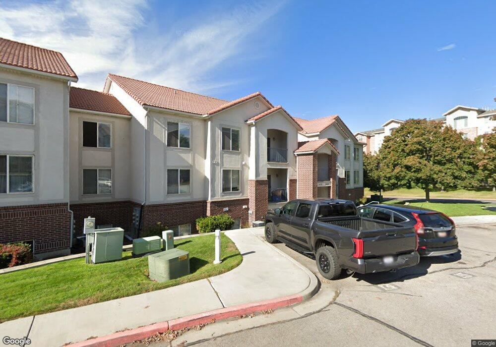
1444 S 430 W Unit 7 Orem, UT 84058
Lakeview NeighborhoodEstimated Value: $309,000 - $326,983
3
Beds
2
Baths
1,158
Sq Ft
$275/Sq Ft
Est. Value
About This Home
This home is located at 1444 S 430 W Unit 7, Orem, UT 84058 and is currently estimated at $317,996, approximately $274 per square foot. 1444 S 430 W Unit 7 is a home located in Utah County with nearby schools including Cherry Hill Elementary School, Lakeridge Jr High School, and Mountain View High School.
Ownership History
Date
Name
Owned For
Owner Type
Purchase Details
Closed on
Aug 21, 2018
Sold by
Murrieta Properties Llc
Bought by
Murrieta Properties Orem Llc
Current Estimated Value
Purchase Details
Closed on
May 18, 2011
Sold by
Lee Marlene
Bought by
Murrieta Properties Llc
Purchase Details
Closed on
Oct 12, 2010
Sold by
Federal National Mortgage Association
Bought by
Lee Marlene
Purchase Details
Closed on
Jun 23, 2010
Sold by
Streeter Adam W
Bought by
Federal National Mortgage Association
Purchase Details
Closed on
Oct 20, 2009
Sold by
Eaton Alliance Inc
Bought by
Streeter Adam W
Purchase Details
Closed on
Nov 26, 2008
Sold by
Streeter Adam W
Bought by
Eaton Alliance Inc
Home Financials for this Owner
Home Financials are based on the most recent Mortgage that was taken out on this home.
Original Mortgage
$145,392
Interest Rate
6.47%
Mortgage Type
Purchase Money Mortgage
Purchase Details
Closed on
Aug 8, 2006
Sold by
Mcbride Michael C
Bought by
Streeter Adam W
Home Financials for this Owner
Home Financials are based on the most recent Mortgage that was taken out on this home.
Original Mortgage
$118,120
Interest Rate
6.7%
Mortgage Type
New Conventional
Purchase Details
Closed on
Oct 3, 2001
Sold by
Mcbride Michael C and Mcbride Cynthia
Bought by
Mcbride Michael C
Purchase Details
Closed on
Jan 31, 2001
Sold by
Mcbride Michael C
Bought by
Mcbride Michael C and Mcbride Cynthia
Home Financials for this Owner
Home Financials are based on the most recent Mortgage that was taken out on this home.
Original Mortgage
$110,426
Interest Rate
7.41%
Mortgage Type
FHA
Purchase Details
Closed on
Jan 24, 2001
Sold by
Mcbride Michael C and Mcbride Cynthia
Bought by
Mcbride Michael C
Home Financials for this Owner
Home Financials are based on the most recent Mortgage that was taken out on this home.
Original Mortgage
$110,426
Interest Rate
7.41%
Mortgage Type
FHA
Purchase Details
Closed on
Oct 28, 1999
Sold by
Mcbride Michael C
Bought by
Mcbride Michael C and Mcbride Cynthia
Create a Home Valuation Report for This Property
The Home Valuation Report is an in-depth analysis detailing your home's value as well as a comparison with similar homes in the area
Home Values in the Area
Average Home Value in this Area
Purchase History
| Date | Buyer | Sale Price | Title Company |
|---|---|---|---|
| Murrieta Properties Orem Llc | -- | None Available | |
| Murrieta Properties Llc | -- | None Available | |
| Lee Marlene | -- | Empire Land Title Inc | |
| Federal National Mortgage Association | $123,285 | Lsi Title Agency Inc | |
| Streeter Adam W | -- | None Available | |
| Eaton Alliance Inc | -- | None Available | |
| Streeter Adam W | -- | First American Title Agency | |
| Mcbride Michael C | -- | First American Title Co | |
| Mcbride Michael C | -- | First American Title Co | |
| Mcbride Michael C | -- | First American Title Co | |
| Mcbride Michael C | -- | Mountain West Title Co |
Source: Public Records
Mortgage History
| Date | Status | Borrower | Loan Amount |
|---|---|---|---|
| Previous Owner | Eaton Alliance Inc | $145,392 | |
| Previous Owner | Streeter Adam W | $118,120 | |
| Previous Owner | Mcbride Michael C | $110,426 |
Source: Public Records
Tax History Compared to Growth
Tax History
| Year | Tax Paid | Tax Assessment Tax Assessment Total Assessment is a certain percentage of the fair market value that is determined by local assessors to be the total taxable value of land and additions on the property. | Land | Improvement |
|---|---|---|---|---|
| 2025 | $1,336 | $320,800 | $35,600 | $285,200 |
| 2024 | $1,336 | $163,405 | $0 | $0 |
| 2023 | $1,196 | $157,135 | $0 | $0 |
| 2022 | $1,146 | $145,970 | $0 | $0 |
| 2021 | $1,080 | $208,200 | $25,000 | $183,200 |
| 2020 | $981 | $185,900 | $22,300 | $163,600 |
| 2019 | $907 | $178,800 | $20,000 | $158,800 |
| 2018 | $871 | $164,000 | $20,000 | $144,000 |
| 2017 | $796 | $80,300 | $0 | $0 |
| 2016 | $769 | $71,500 | $0 | $0 |
| 2015 | $772 | $67,925 | $0 | $0 |
| 2014 | $754 | $66,000 | $0 | $0 |
Source: Public Records
Map
Nearby Homes
- 335 W 1410 S
- 467 W 1640 S
- 302 W Hidden Hollow Dr
- 314 W 1700 S
- 139 W Hidden Hollow Dr
- 1676 S Lakewood Dr
- 1633 S 165 W
- 537 W 1770 S
- 543 W 1770 S
- 1710 S 165 W
- 1700 S Sandhill Rd Unit C205
- 1700 S Sandhill Rd Unit D203
- 1700 S Sandhill Rd Unit A303
- 352 W 1060 S
- 1550 S Main St
- 150 W Westview Dr
- 1451 S 110 E Unit 108
- 1707 S 50 E
- 1006 W 1360 S
- 881 S 635 W
- 1452 S 430 W
- 1448 S 430 W
- 1452 S 430 W Unit 9
- 1448 S 430 W Unit 8
- 1450 S 430 W
- 1446 S 430 W
- 1450 S 430 W Unit 11
- 1446 S 430 W Unit 10
- 1454 S 430 W
- 1454 S 430 W Unit 12
- 1432 S 430 W
- 1432 S 430 W Unit 1
- 1440 S 430 W
- 1440 S 430 W Unit 3
- 1464 S 430 W
- 1460 S 430 W
- 1464 S 430 W Unit 15
- 1460 S 430 W Unit 14
- 1456 S 430 W Unit 13
- 1436 S 430 W