Estimated Value: $712,000 - $775,488
4
Beds
4
Baths
1,968
Sq Ft
$377/Sq Ft
Est. Value
About This Home
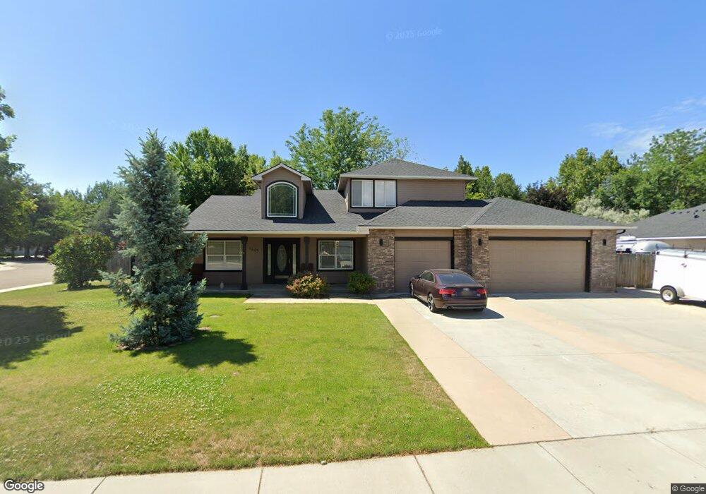
This home is located at 1445 W Powder Ct, Eagle, ID 83616 and is currently estimated at $742,622, approximately $377 per square foot. 1445 W Powder Ct is a home located in Ada County with nearby schools including Eagle Middle School, Eagle High School, and Eagle Adventist Christian School & Preschool.
Ownership History
Date
Name
Owned For
Owner Type
Purchase Details
Closed on
Oct 12, 2011
Sold by
Phillips Lisa M
Bought by
Phillips Deborah G and Deborah G Phillips Trust
Current Estimated Value
Purchase Details
Closed on
Apr 24, 2002
Sold by
Federal Home Loan Mortgage Corporation
Bought by
Phillips Lisa M
Home Financials for this Owner
Home Financials are based on the most recent Mortgage that was taken out on this home.
Original Mortgage
$170,000
Outstanding Balance
$71,829
Interest Rate
7.08%
Mortgage Type
Purchase Money Mortgage
Estimated Equity
$670,793
Create a Home Valuation Report for This Property
The Home Valuation Report is an in-depth analysis detailing your home's value as well as a comparison with similar homes in the area
Home Values in the Area
Average Home Value in this Area
Purchase History
| Date | Buyer | Sale Price | Title Company |
|---|---|---|---|
| Phillips Deborah G | -- | First American Title & Escro | |
| Phillips Lisa M | -- | First American |
Source: Public Records
Mortgage History
| Date | Status | Borrower | Loan Amount |
|---|---|---|---|
| Open | Phillips Lisa M | $170,000 |
Source: Public Records
Tax History Compared to Growth
Tax History
| Year | Tax Paid | Tax Assessment Tax Assessment Total Assessment is a certain percentage of the fair market value that is determined by local assessors to be the total taxable value of land and additions on the property. | Land | Improvement |
|---|---|---|---|---|
| 2025 | $2,409 | $651,300 | -- | -- |
| 2024 | $2,492 | $590,400 | -- | -- |
| 2023 | $2,519 | $560,100 | $0 | $0 |
| 2022 | $2,808 | $627,300 | $0 | $0 |
| 2021 | $2,753 | $458,400 | $0 | $0 |
| 2020 | $3,034 | $389,900 | $0 | $0 |
| 2019 | $3,662 | $384,600 | $0 | $0 |
| 2018 | $3,297 | $322,000 | $0 | $0 |
| 2017 | $3,479 | $321,300 | $0 | $0 |
| 2016 | $3,390 | $299,000 | $0 | $0 |
| 2015 | $1,301 | $263,200 | $0 | $0 |
| 2012 | -- | $217,800 | $0 | $0 |
Source: Public Records
Map
Nearby Homes
- 1563 W Colville Ct
- 28 S Riverview St
- 1492 W Kenai Ct
- Selway Plan at Benari Estates - Benari
- Danskin Plan at Benari Estates - Benari
- Bannock Plan at Benari Estates - Benari
- Clearwater Plan at Benari Estates - Benari
- 251 N Boulder Ridge Way
- 313 N Boulder Ridge Way
- 1893 W Timberstone Dr
- 252 N Hunter Creek Ave
- 270 N Hunter Creek Ave
- 249 N Hunter Creek Ave
- 62 S Stephenson St
- 1934 W Yellowstone Dr
- 222 Dawn St
- 2046 W Freya Ct
- 2050 W Freya Ct
- 2042 W Freya Ct
- 296 N Clearpoint Way
- 1453 W Powder Ct
- 1413 W Powder Ct
- 1444 W Powder Ct
- 1420 W Powder Ct
- 1397 W Powder Ct
- 1412 W Powder Ct
- 1452 W Powder Ct
- 1396 W Powder Ct
- 1436 W Powder Ct
- 1428 W Powder Ct
- 1404 W Powder Ct
- 1517 W Powder Ct
- 1509 W Powder Ct
- 1407 W Deadwood Ct
- 1393 W Deadwood Ct
- 244 N Payette Way
- 1525 W Powder Ct
- 1484 W Powder Ct
- 1381 W Deadwood Ct
- 1532 W Powder Ct