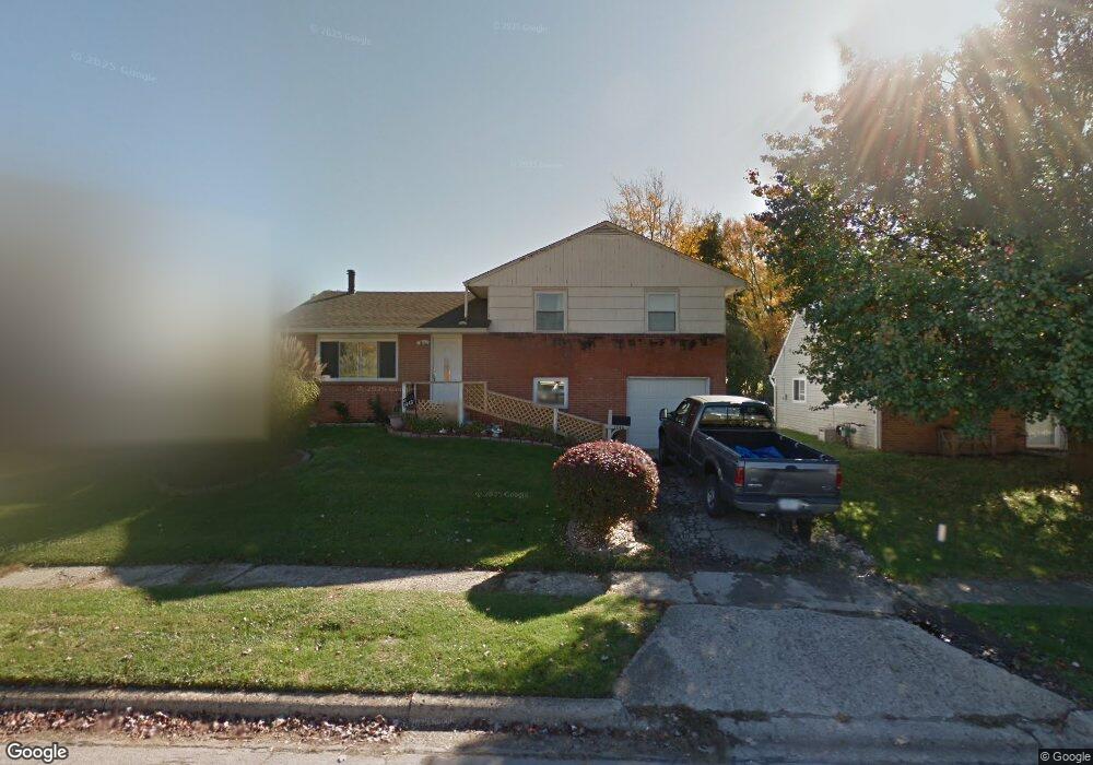
1446 Benson Dr Columbus, OH 43227
Shady Lane NeighborhoodEstimated Value: $206,000 - $231,000
3
Beds
2
Baths
1,294
Sq Ft
$168/Sq Ft
Est. Value
About This Home
This home is located at 1446 Benson Dr, Columbus, OH 43227 and is currently estimated at $217,665, approximately $168 per square foot. 1446 Benson Dr is a home located in Franklin County with nearby schools including Shady Lane Elementary School, Sherwood Middle School, and Walnut Ridge High School.
Ownership History
Date
Name
Owned For
Owner Type
Purchase Details
Closed on
Mar 7, 2001
Sold by
Howell John W
Bought by
Smith Michael A
Current Estimated Value
Home Financials for this Owner
Home Financials are based on the most recent Mortgage that was taken out on this home.
Original Mortgage
$88,202
Outstanding Balance
$30,875
Interest Rate
7.18%
Mortgage Type
FHA
Estimated Equity
$186,791
Purchase Details
Closed on
Sep 11, 1995
Sold by
Johns Lawrence H
Bought by
John W Howell
Home Financials for this Owner
Home Financials are based on the most recent Mortgage that was taken out on this home.
Original Mortgage
$67,300
Interest Rate
7.76%
Mortgage Type
VA
Purchase Details
Closed on
Aug 4, 1994
Sold by
Taylor Douglas Leon
Bought by
Lawrence H Johns
Purchase Details
Closed on
Mar 29, 1988
Create a Home Valuation Report for This Property
The Home Valuation Report is an in-depth analysis detailing your home's value as well as a comparison with similar homes in the area
Home Values in the Area
Average Home Value in this Area
Purchase History
We collect this data history from publicly available records. To have your information removed, we recommend requesting removal directly through your county’s website.
| Date | Buyer | Sale Price | Title Company |
|---|---|---|---|
| Smith Michael A | $88,900 | George Pritsolas Title | |
| John W Howell | $66,000 | -- | |
| Lawrence H Johns | $39,933 | -- | |
| -- | -- | -- |
Source: Public Records
Mortgage History
We collect this data history from publicly available records. To have your information removed, we recommend requesting removal directly through your county’s website.
| Date | Status | Borrower | Loan Amount |
|---|---|---|---|
| Open | Smith Michael A | $88,202 | |
| Previous Owner | John W Howell | $67,300 |
Source: Public Records
Tax History
| Year | Tax Paid | Tax Assessment Tax Assessment Total Assessment is a certain percentage of the fair market value that is determined by local assessors to be the total taxable value of land and additions on the property. | Land | Improvement |
|---|---|---|---|---|
| 2025 | $2,859 | $63,700 | $18,130 | $45,570 |
| 2024 | $2,859 | $63,700 | $18,130 | $45,570 |
| 2023 | $3,186 | $63,700 | $18,130 | $45,570 |
| 2022 | $1,587 | $30,590 | $6,790 | $23,800 |
| 2021 | $1,589 | $30,590 | $6,790 | $23,800 |
| 2020 | $1,591 | $30,590 | $6,790 | $23,800 |
| 2019 | $1,469 | $24,220 | $5,460 | $18,760 |
| 2018 | $1,431 | $24,220 | $5,460 | $18,760 |
| 2017 | $1,468 | $24,220 | $5,460 | $18,760 |
| 2016 | $1,538 | $23,210 | $5,880 | $17,330 |
| 2015 | $1,396 | $23,210 | $5,880 | $17,330 |
| 2014 | $1,399 | $23,210 | $5,880 | $17,330 |
| 2013 | $812 | $27,300 | $6,930 | $20,370 |
Source: Public Records
Map
Nearby Homes
- 1422 Benson Dr
- 1489 Blaine Dr
- 1321 Country Club Rd
- 1264 Shady Lane Rd
- 4562 Grimsby Rd
- 4636 Dundee Ave
- 4530 Amesbury Rd
- 1470 Efner Dr
- 4467 Grimsby Rd
- 4487 Dundee Ave
- 4676 Belfast Dr
- 4492 Keeler Dr
- 1085 Shady Lane Rd
- 4991 Justin Rd
- 4467 Ellery Dr
- 4303 Colby Ave
- 1654 Wilton Dr
- 1301 Bernhard Rd
- 4289 Astor Ave
- 1646 Clyde Place
- 1440 Benson Dr
- 1454 Benson Dr
- 1460 Benson Dr
- 1434 Benson Dr
- 1463 Country Club Rd
- 1469 Country Club Rd
- 1457 Country Club Rd
- 1470 Benson Dr
- 1428 Benson Dr
- 1441 Benson Dr
- 1477 Country Club Rd
- 1435 Benson Dr
- 1447 Benson Dr
- 1449 Country Club Rd
- 1478 Benson Dr
- 1453 Benson Dr
- 1486 Benson Dr
- 1485 Country Club Rd
- 1441 Country Club Rd
- 1423 Benson Dr
Your Personal Tour Guide
Ask me questions while you tour the home.