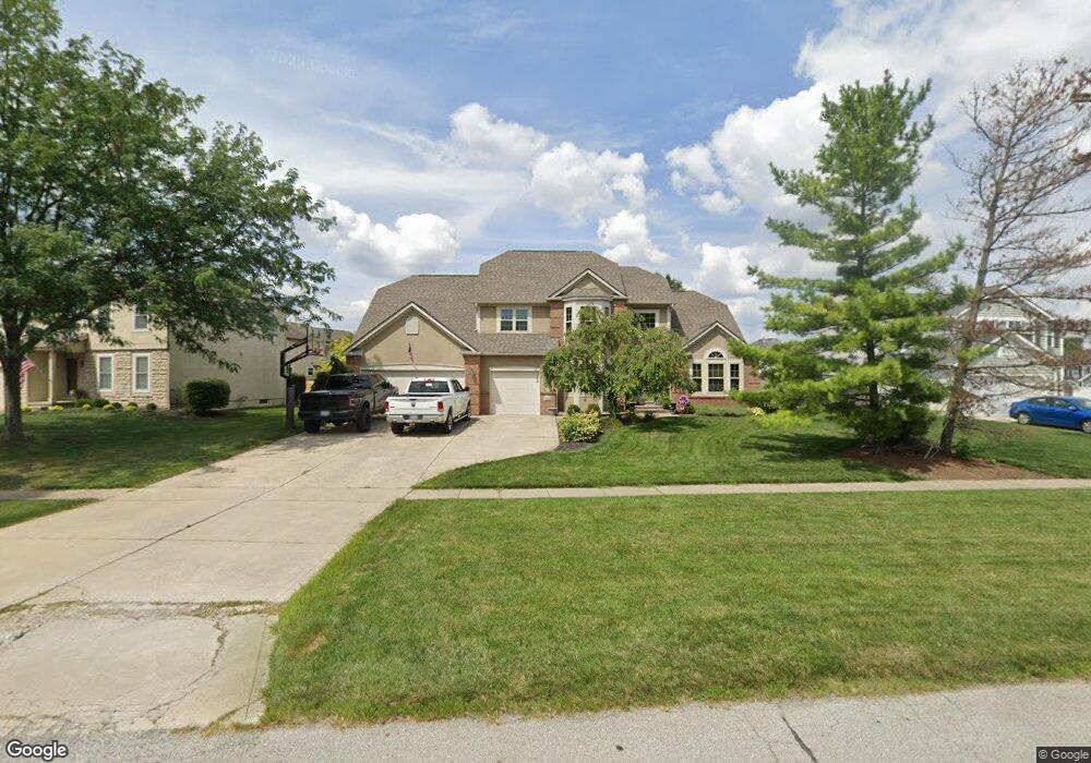
1446 Hawthorne Pkwy Grove City, OH 43123
Estimated Value: $439,000 - $549,000
4
Beds
4
Baths
3,500
Sq Ft
$143/Sq Ft
Est. Value
About This Home
This home is located at 1446 Hawthorne Pkwy, Grove City, OH 43123 and is currently estimated at $499,437, approximately $142 per square foot. 1446 Hawthorne Pkwy is a home located in Franklin County with nearby schools including Buckeye Woods Elementary School, Hayes Intermediate School, and Jackson Middle School.
Ownership History
Date
Name
Owned For
Owner Type
Purchase Details
Closed on
Nov 16, 2012
Sold by
Black Frances P
Bought by
Donohoe Marcus and Donohoe Terra
Current Estimated Value
Home Financials for this Owner
Home Financials are based on the most recent Mortgage that was taken out on this home.
Original Mortgage
$25,200
Outstanding Balance
$17,397
Interest Rate
3.37%
Mortgage Type
Purchase Money Mortgage
Estimated Equity
$482,040
Purchase Details
Closed on
Jan 11, 2008
Sold by
Gorby Larry A and Gorby Linda L
Bought by
Black Larry D and Black Frances P
Purchase Details
Closed on
Sep 3, 2004
Sold by
Adams Julius E and Adams Deborah K
Bought by
Gorby Larry A and Gorby Linda L
Home Financials for this Owner
Home Financials are based on the most recent Mortgage that was taken out on this home.
Original Mortgage
$125,000
Interest Rate
5.32%
Mortgage Type
Purchase Money Mortgage
Purchase Details
Closed on
Oct 9, 1992
Create a Home Valuation Report for This Property
The Home Valuation Report is an in-depth analysis detailing your home's value as well as a comparison with similar homes in the area
Home Values in the Area
Average Home Value in this Area
Purchase History
| Date | Buyer | Sale Price | Title Company |
|---|---|---|---|
| Donohoe Marcus | $270,000 | None Available | |
| Black Larry D | $330,000 | Valmer Land | |
| Gorby Larry A | $265,500 | Chicago Tit | |
| -- | -- | -- |
Source: Public Records
Mortgage History
| Date | Status | Borrower | Loan Amount |
|---|---|---|---|
| Open | Donohoe Marcus | $25,200 | |
| Closed | Gorby Larry A | $125,000 |
Source: Public Records
Tax History Compared to Growth
Tax History
| Year | Tax Paid | Tax Assessment Tax Assessment Total Assessment is a certain percentage of the fair market value that is determined by local assessors to be the total taxable value of land and additions on the property. | Land | Improvement |
|---|---|---|---|---|
| 2024 | $7,053 | $155,090 | $33,640 | $121,450 |
| 2023 | $6,953 | $155,085 | $33,635 | $121,450 |
| 2022 | $6,781 | $111,200 | $15,330 | $95,870 |
| 2021 | $6,912 | $111,200 | $15,330 | $95,870 |
| 2020 | $6,890 | $111,200 | $15,330 | $95,870 |
| 2019 | $6,195 | $92,760 | $12,780 | $79,980 |
| 2018 | $6,886 | $92,760 | $12,780 | $79,980 |
| 2017 | $6,874 | $92,760 | $12,780 | $79,980 |
| 2016 | $7,598 | $104,830 | $15,400 | $89,430 |
| 2015 | $7,600 | $104,830 | $15,400 | $89,430 |
| 2014 | $7,606 | $104,830 | $15,400 | $89,430 |
| 2013 | $3,418 | $99,820 | $14,665 | $85,155 |
Source: Public Records
Map
Nearby Homes
- 6295 Rising Sun Dr
- 6259 Rising Sun Dr
- 6229 Brookmeade Cir
- 1571 Cree Ct
- 6477 Buckeye Path Dr S
- 1370 Wild Horse Dr
- 5976 Sweet Basil Ln
- 6032 Sweet Basil Ln
- 6075 Sweet Basil Ln
- 5990 Sweet Basil Ln
- 6358 Shawnee St
- 6003 Windcliff Dr E
- 6090 Windcliff Dr E
- 6132 Windcliff Dr E
- 1390 Hemetite Dr
- 1019 Morning Bird Ct
- 1717 London Groveport Rd
- 6092 Winnebago St
- 5971 Wynnewood Dr
- 6279 Honey Farm Way
- 1434 Hawthorne Pkwy
- 1458 Hawthorne Pkwy
- 6272 Buckeye Pkwy
- 6279 Rising Sun Dr
- 1470 Hawthorne Pkwy
- 6262 Buckeye Pkwy
- 6269 Rising Sun Dr
- 1435 Hawthorne Pkwy
- 1455 Hawthorne Pkwy
- 1465 Hawthorne Pkwy
- 1445 Hawthorne Pkwy
- 6321 Rising Sun Dr
- 6252 Buckeye Pkwy
- 1475 Hawthorne Pkwy
- 1475 Hawthorne Pkwy Unit 1
- 6289 Brookmeade Cir
- 6335 Rising Sun Dr
- 6294 Rising Sun Dr
- 6282 Rising Sun Dr
- 6249 Rising Sun Dr