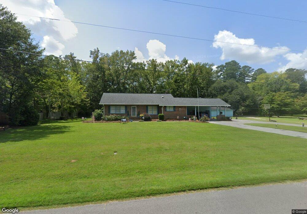
1447 Bennett Cir Holly Hill, SC 29059
Estimated Value: $270,195 - $321,000
4
Beds
3
Baths
1,641
Sq Ft
$179/Sq Ft
Est. Value
About This Home
This home is located at 1447 Bennett Cir, Holly Hill, SC 29059 and is currently estimated at $294,299, approximately $179 per square foot. 1447 Bennett Cir is a home located in Orangeburg County with nearby schools including Holly Hill Elementary School, Holly Hill Elementary, and Holly Hill-Roberts Middle.
Ownership History
Date
Name
Owned For
Owner Type
Purchase Details
Closed on
Dec 6, 2006
Sold by
Hill Barbara Jean Hartzog
Bought by
Sellers Alton G and Sellers Emma W
Current Estimated Value
Home Financials for this Owner
Home Financials are based on the most recent Mortgage that was taken out on this home.
Original Mortgage
$197,000
Outstanding Balance
$117,390
Interest Rate
6.25%
Mortgage Type
Adjustable Rate Mortgage/ARM
Estimated Equity
$176,909
Create a Home Valuation Report for This Property
The Home Valuation Report is an in-depth analysis detailing your home's value as well as a comparison with similar homes in the area
Home Values in the Area
Average Home Value in this Area
Purchase History
| Date | Buyer | Sale Price | Title Company |
|---|---|---|---|
| Sellers Alton G | $197,000 | None Available |
Source: Public Records
Mortgage History
| Date | Status | Borrower | Loan Amount |
|---|---|---|---|
| Open | Sellers Alton G | $197,000 |
Source: Public Records
Tax History Compared to Growth
Tax History
| Year | Tax Paid | Tax Assessment Tax Assessment Total Assessment is a certain percentage of the fair market value that is determined by local assessors to be the total taxable value of land and additions on the property. | Land | Improvement |
|---|---|---|---|---|
| 2024 | $1,232 | $8,196 | $1,820 | $6,376 |
| 2023 | $1,011 | $6,260 | $1,440 | $4,820 |
| 2022 | $993 | $6,260 | $1,440 | $4,820 |
| 2021 | $982 | $6,260 | $1,440 | $4,820 |
| 2020 | $967 | $6,260 | $1,440 | $4,820 |
| 2019 | $971 | $6,260 | $1,440 | $4,820 |
| 2018 | $842 | $5,464 | $1,440 | $4,024 |
| 2017 | $836 | $5,464 | $0 | $0 |
| 2016 | $824 | $5,464 | $0 | $0 |
| 2015 | $801 | $5,464 | $0 | $0 |
| 2014 | $801 | $5,464 | $1,440 | $4,024 |
| 2013 | -- | $5,508 | $1,440 | $4,068 |
Source: Public Records
Map
Nearby Homes
- 1301 Bennett Cir
- 264 Walters Rd
- 0 Lindstedt Ln
- 1691 Bennett Cir
- 1000 Holly St
- 220 Brooks Dr
- 0 Bunch Ford Rd Unit 25021235
- BRANDON Plan at Evergreen
- CALI Plan at Evergreen
- HELENA Plan at Evergreen
- DOWNING Plan at Evergreen
- SULLIVAN Plan at Evergreen
- 310 Bunch Ford Rd
- 130 Culbertson Ct
- 114 Culbertson Ct
- 414 Brooks Dr
- 128 Culbertson Ct
- 129 Culbertson Cir
- 132 Brooks Dr
- 0 Peake St
- 1433 Bennett Cir
- 1435 Bennett Cir
- 1423 Bennett Cir
- 1444 Bennett Cir
- 1471 Bennett Cir
- 1432 Bennett Cir
- 1450 Brant Ave
- 1430 Brant Ave
- 1454 Bennett Cir
- 1415 Bennett Cir
- 1422 Bennett Cir
- 1465 Brant Ave
- 1513 Bennett Cir
- 1132 Mccoy St
- 1422 Brant Ave
- 1402 Brant Ave
- 1474 Bennett Cir
- 1443 Brant Ave
- 1433 Brant Ave
- 1400 Bennett Cir