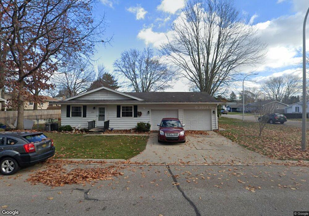
1447 Devonshire Ln Port Huron, MI 48060
Estimated Value: $225,791 - $258,000
2
Beds
1
Bath
1,810
Sq Ft
$134/Sq Ft
Est. Value
About This Home
This home is located at 1447 Devonshire Ln, Port Huron, MI 48060 and is currently estimated at $242,698, approximately $134 per square foot. 1447 Devonshire Ln is a home located in St. Clair County with nearby schools including Garfield Elementary School, Holland Woods Middle School, and Port Huron Northern High School.
Ownership History
Date
Name
Owned For
Owner Type
Purchase Details
Closed on
Nov 28, 2023
Sold by
Moss Deborah K
Bought by
George C Moss Jr And Deborah K Moss Trust
Current Estimated Value
Purchase Details
Closed on
Jun 24, 2020
Sold by
Richard Turner
Bought by
Moss Deborah K
Purchase Details
Closed on
Jun 16, 2020
Sold by
Richard Turner
Bought by
Moss Deborah K
Create a Home Valuation Report for This Property
The Home Valuation Report is an in-depth analysis detailing your home's value as well as a comparison with similar homes in the area
Home Values in the Area
Average Home Value in this Area
Purchase History
| Date | Buyer | Sale Price | Title Company |
|---|---|---|---|
| George C Moss Jr And Deborah K Moss Trust | -- | None Listed On Document | |
| Moss Deborah K | -- | None Listed On Document | |
| Moss Deborah K | -- | None Listed On Document |
Source: Public Records
Tax History
| Year | Tax Paid | Tax Assessment Tax Assessment Total Assessment is a certain percentage of the fair market value that is determined by local assessors to be the total taxable value of land and additions on the property. | Land | Improvement |
|---|---|---|---|---|
| 2025 | $3,258 | $101,100 | $0 | $0 |
| 2024 | $3,172 | $93,100 | $0 | $0 |
| 2023 | $3,004 | $82,600 | $0 | $0 |
| 2022 | $3,085 | $73,500 | $0 | $0 |
| 2020 | $2,957 | $66,300 | $66,300 | $0 |
| 2019 | $2,903 | $57,900 | $0 | $0 |
| 2018 | $2,838 | $57,900 | $0 | $0 |
| 2017 | $2,604 | $53,000 | $0 | $0 |
| 2016 | $2,331 | $53,000 | $0 | $0 |
| 2015 | $2,287 | $47,100 | $47,100 | $0 |
| 2014 | $2,287 | $42,800 | $42,800 | $0 |
| 2013 | -- | $41,800 | $0 | $0 |
Source: Public Records
Map
Nearby Homes
- 3165 10th Ave
- 1020 Sanborn St
- 1813 N Woodland Dr
- 810 Holland Ave Unit 8
- 1828 Kennelworth Dr
- 3444 Riverside Dr
- 2915 Linda Ct
- 817 Florida Ave
- 3455 Gratiot Ave
- 3316 Hickory Ln
- 2915 10th Ave
- 2846 Cooper Ave
- 2835 17th Ave
- 3142 Wright St
- 3945 Butternut Ct
- 3947 Butternut Ct
- 2224 Garfield St
- 2857 Riverside Dr
- 2215 Hancock St
- 4033 Helen Ave
- 1443 Devonshire Ln
- 3460 Appomattox Dr Unit 3462
- 3440 Appomattox Dr
- 1444 Hazelwood Ln Unit Bldg-Unit
- 1444 Hazelwood Ln
- 1437 Devonshire Ln
- 1448 Devonshire Ln
- 1433 Devonshire Ln
- 1444 Devonshire Ln
- 0 Hazelwood Ln
- 1436 Devonshire Ln
- 1438 Hazelwood Ln
- 1432 Devonshire Ln
- 1432 Hazelwood Ln
- 0 Williamsburgh Dr Unit G31197150
- 3505 Williamsburg Dr
- 1423 Devonshire Ln
- 1523 Hazelwood Ln Unit 1529-1531 Hazelwood
- 3424 Appomattox Dr Unit 3426
- 1437 Coventry Ln
Your Personal Tour Guide
Ask me questions while you tour the home.