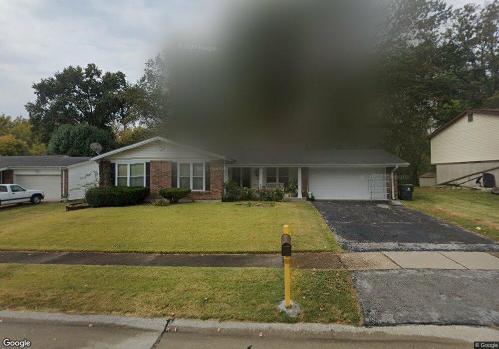
14470 Avocado Ln Florissant, MO 63034
Estimated Value: $244,000 - $280,000
4
Beds
2
Baths
1,828
Sq Ft
$141/Sq Ft
Est. Value
About This Home
This home is located at 14470 Avocado Ln, Florissant, MO 63034 and is currently estimated at $257,470, approximately $140 per square foot. 14470 Avocado Ln is a home located in St. Louis County with nearby schools including Jamestown Elementary School, Central Middle School, and Hazelwood Central High School.
Ownership History
Date
Name
Owned For
Owner Type
Purchase Details
Closed on
Sep 3, 2015
Sold by
Hickmon Mahlon
Bought by
Johnson Reba
Current Estimated Value
Home Financials for this Owner
Home Financials are based on the most recent Mortgage that was taken out on this home.
Original Mortgage
$78,551
Outstanding Balance
$62,403
Interest Rate
4.25%
Mortgage Type
FHA
Estimated Equity
$195,067
Purchase Details
Closed on
Oct 14, 2010
Sold by
Lodato Vito and Lodato Trudee
Bought by
Hickmon Mahlon and Hickmon Mary J
Create a Home Valuation Report for This Property
The Home Valuation Report is an in-depth analysis detailing your home's value as well as a comparison with similar homes in the area
Home Values in the Area
Average Home Value in this Area
Purchase History
| Date | Buyer | Sale Price | Title Company |
|---|---|---|---|
| Johnson Reba | $80,000 | Continental Title Company | |
| Hickmon Mahlon | $119,000 | U S Title |
Source: Public Records
Mortgage History
| Date | Status | Borrower | Loan Amount |
|---|---|---|---|
| Open | Johnson Reba | $78,551 |
Source: Public Records
Tax History Compared to Growth
Tax History
| Year | Tax Paid | Tax Assessment Tax Assessment Total Assessment is a certain percentage of the fair market value that is determined by local assessors to be the total taxable value of land and additions on the property. | Land | Improvement |
|---|---|---|---|---|
| 2025 | $3,428 | $42,920 | $4,330 | $38,590 |
| 2024 | $3,428 | $37,700 | $3,820 | $33,880 |
| 2023 | $3,416 | $37,700 | $3,820 | $33,880 |
| 2022 | $2,734 | $26,790 | $6,630 | $20,160 |
| 2021 | $2,588 | $26,790 | $6,630 | $20,160 |
| 2020 | $2,513 | $24,230 | $4,980 | $19,250 |
| 2019 | $2,473 | $24,230 | $4,980 | $19,250 |
| 2018 | $2,214 | $20,030 | $2,640 | $17,390 |
| 2017 | $2,211 | $20,030 | $2,640 | $17,390 |
| 2016 | $1,872 | $16,640 | $2,640 | $14,000 |
| 2015 | $1,829 | $16,640 | $2,640 | $14,000 |
| 2014 | -- | $20,790 | $2,740 | $18,050 |
Source: Public Records
Map
Nearby Homes
- 5618 Madlar Ln
- 5220 Delcastle Dr
- 5625 Delcastle Dr
- 5473 Misty Crossing Ct
- 210 Behlmann Meadows Way
- 173 Behlmann Meadows Way
- 4681 Richmond Forest Dr
- 4629 Richmond Forest Dr
- 12705 Stubwood Dr
- 6360 Silver Fox Dr
- 12456 Sea Lane Dr Unit A
- 12435 Sea Lane Dr Unit 5
- 13630 Old Halls Ferry Rd
- 12750 Needle Point Ct
- 13032 Kinsley Heights Dr
- 13107 Ambrose Ct
- 13124 Crestwood Bend Ln
- 4308 Hollow Brook Ct
- 13125 Crestwood Bend Ln
- 14333 River Oaks Ct
- 14490 Avocado Ln
- 14450 Avocado Ln
- 14500 Avocado Ln
- 14430 Avocado Ln
- 14495 Avocado Ln
- 14475 Avocado Ln
- 14455 Avocado Ln
- 14520 Avocado Ln
- 14420 Avocado Ln
- 14435 Avocado Ln
- 14525 Avocado Ln
- 14580 Avocado Ln
- 14491 Soho Dr
- 14410 Avocado Ln
- 5628 Madlar Ln
- 14501 Soho Dr
- 5617 Madlar Ln
- 14565 Avocado Ln
- 14481 Soho Dr
- 14511 Soho Dr