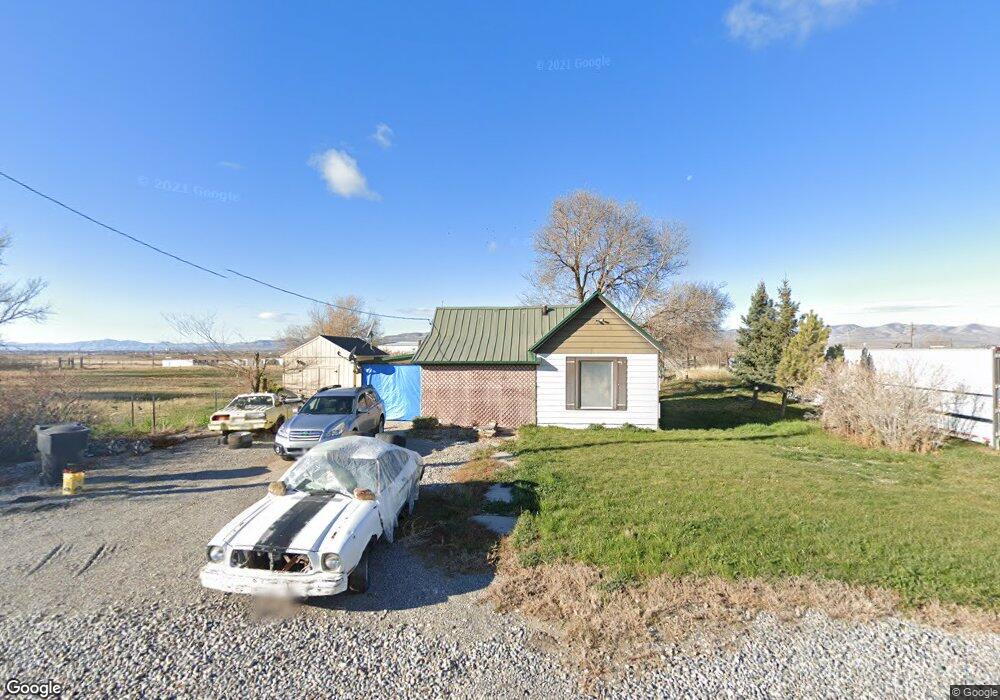
14485 N 3100 W Collinston, UT 84306
Estimated Value: $299,730 - $449,000
2
Beds
1
Bath
849
Sq Ft
$405/Sq Ft
Est. Value
About This Home
This home is located at 14485 N 3100 W, Collinston, UT 84306 and is currently estimated at $344,183, approximately $405 per square foot. 14485 N 3100 W is a home located in Box Elder County with nearby schools including Fielding School, Bear River Middle School, and Alice C. Harris Intermediate School.
Ownership History
Date
Name
Owned For
Owner Type
Purchase Details
Closed on
May 8, 2025
Sold by
Ashby Moroni and James And Sharon Ashby Revocable Family
Bought by
Ashby James Moroni and Ashby Stacey
Current Estimated Value
Purchase Details
Closed on
Dec 16, 2019
Sold by
Ashby J Moroni J and Ashby Stacey
Bought by
Ashby James Moroni and Ashby Stacey
Home Financials for this Owner
Home Financials are based on the most recent Mortgage that was taken out on this home.
Original Mortgage
$126,000
Interest Rate
3.7%
Mortgage Type
New Conventional
Purchase Details
Closed on
Jun 2, 2005
Sold by
Ashby James L and Ashby Sharon N
Bought by
Ashby J Moroni and Ashby Stacey
Create a Home Valuation Report for This Property
The Home Valuation Report is an in-depth analysis detailing your home's value as well as a comparison with similar homes in the area
Home Values in the Area
Average Home Value in this Area
Purchase History
| Date | Buyer | Sale Price | Title Company |
|---|---|---|---|
| Ashby James Moroni | -- | Us Title | |
| Ashby James Moroni | -- | American Secure Ttl Tremonto | |
| Ashby J Moroni | -- | None Available |
Source: Public Records
Mortgage History
| Date | Status | Borrower | Loan Amount |
|---|---|---|---|
| Previous Owner | Ashby James Moroni | $126,000 |
Source: Public Records
Tax History Compared to Growth
Tax History
| Year | Tax Paid | Tax Assessment Tax Assessment Total Assessment is a certain percentage of the fair market value that is determined by local assessors to be the total taxable value of land and additions on the property. | Land | Improvement |
|---|---|---|---|---|
| 2025 | $1,225 | $240,276 | $130,000 | $110,276 |
| 2024 | $1,071 | $238,582 | $130,000 | $108,582 |
| 2023 | $1,066 | $240,044 | $130,000 | $110,044 |
| 2022 | $920 | $107,333 | $35,750 | $71,583 |
| 2021 | $809 | $91,771 | $30,000 | $61,771 |
| 2020 | $499 | $91,771 | $30,000 | $61,771 |
| 2019 | $462 | $44,812 | $16,500 | $28,312 |
| 2018 | $453 | $41,119 | $16,500 | $24,619 |
| 2017 | $470 | $74,762 | $16,500 | $44,762 |
| 2016 | $453 | $39,947 | $16,500 | $23,447 |
| 2015 | $422 | $37,815 | $16,500 | $21,315 |
| 2014 | $422 | $36,800 | $16,500 | $20,300 |
| 2013 | -- | $34,955 | $16,500 | $18,455 |
Source: Public Records
Map
Nearby Homes
- 3536 W 14100 N
- 13700 N 3100 W
- 15125 N 4400 W
- 15920 N 4000 W Unit 14
- 4770 W 13600 N
- 14296 N 5350 W
- 303 S Center St
- 95 E 100 S
- 15270 N 5475 W
- 15600 N Beaver Dam Rd
- 95 W 100 N
- 1747 N 8150 W
- 14360 N 6000 W
- 14376 N 6000 W
- 14345 N 6000 W
- 16580 N 5200 W
- 11990 N 4800 W
- 9791 N Highway 38 Unit 10
- 9835 N Highway 38 Unit 11
- 9743 N Highway 38 Unit 8
- 14505 N 3100 W
- 14460 N 3100 W
- 14425 N 3100 W
- 14580 N Highway 38
- 3205 W 14600 N
- 14594 N Highway 38
- 14610 N Highway 38
- 14260 N Highway 38
- 14255 N 3100 W
- 3370 W 14600 N
- 14185 N 3100 W
- 14185 N 3100 W
- 14130 N Highway 38
- 14100 N 3100 W
- 14074 N 3100 W
- 14046 N 3100 W
- 14016 N 3100 W
- 13988 N 3100 W
- 13984 N 3100 W
- 13885 N 3100 W Unit 1