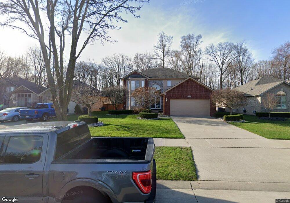
14488 Toussaint Ct Unit Bldg-Unit Sterling Heights, MI 48313
Estimated Value: $441,000 - $507,000
3
Beds
4
Baths
1,859
Sq Ft
$254/Sq Ft
Est. Value
About This Home
This home is located at 14488 Toussaint Ct Unit Bldg-Unit, Sterling Heights, MI 48313 and is currently estimated at $472,623, approximately $254 per square foot. 14488 Toussaint Ct Unit Bldg-Unit is a home located in Macomb County with nearby schools including Graebner Elementary School, Bemis Junior High School, and Henry Ford II High School.
Ownership History
Date
Name
Owned For
Owner Type
Purchase Details
Closed on
Mar 20, 2018
Sold by
Stanaj John
Bought by
Soma Leven
Current Estimated Value
Purchase Details
Closed on
Jun 22, 2011
Sold by
Deutsche Bank National Trust Company
Bought by
Stanaj John
Purchase Details
Closed on
May 21, 2010
Sold by
Ingrao Diane L
Bought by
Deutsche Bank National Trust Company
Purchase Details
Closed on
May 20, 2005
Sold by
Iacopelli Enterprises Inc
Bought by
Ingrao Diane L
Create a Home Valuation Report for This Property
The Home Valuation Report is an in-depth analysis detailing your home's value as well as a comparison with similar homes in the area
Home Values in the Area
Average Home Value in this Area
Purchase History
| Date | Buyer | Sale Price | Title Company |
|---|---|---|---|
| Soma Leven | $303,750 | Title Connect Llc | |
| Stanaj John | $164,199 | Sun Title Agency | |
| Deutsche Bank National Trust Company | $334,518 | None Available | |
| Ingrao Diane L | $320,475 | First American Title Ins Co |
Source: Public Records
Tax History Compared to Growth
Tax History
| Year | Tax Paid | Tax Assessment Tax Assessment Total Assessment is a certain percentage of the fair market value that is determined by local assessors to be the total taxable value of land and additions on the property. | Land | Improvement |
|---|---|---|---|---|
| 2025 | $10,352 | $240,400 | $0 | $0 |
| 2024 | $6,426 | $220,700 | $0 | $0 |
| 2023 | $6,066 | $197,900 | $0 | $0 |
| 2022 | $6,324 | $178,700 | $0 | $0 |
| 2021 | $6,193 | $171,300 | $0 | $0 |
| 2020 | $5,524 | $160,500 | $0 | $0 |
| 2019 | $3,564 | $155,400 | $0 | $0 |
| 2018 | $3,865 | $131,400 | $0 | $0 |
| 2017 | $3,689 | $122,900 | $15,200 | $107,700 |
| 2016 | $3,564 | $122,900 | $0 | $0 |
| 2015 | -- | $115,300 | $0 | $0 |
| 2014 | -- | $97,900 | $0 | $0 |
Source: Public Records
Map
Nearby Homes
- 14603 Cornell Dr
- 42640 Park Cresent Dr
- 14289 Hope Dr
- 14941 Loyola Dr
- 42633 Park Cresent Dr Unit 35
- 14554 Alma Dr
- 14993 Clemson Dr
- 14548 Holborn Dr Unit 24
- 13980 Amanda Dr
- 43038 Strand Dr Unit 46
- 14700 19 Mile Rd
- 14579 Vauxhall Dr Unit 84
- 43103 Strand Dr Unit 34
- 43014 Strand Dr Unit 43
- 41558 Harvard Dr
- 43203 Strand Dr Unit 23
- 14239 Alpena Dr
- 42917 Freeport Dr
- 43146 Dante Ct
- 42755 Hayes Rd
- 14488 Toussaint Ct Unit 11
- 14476 Toussaint Ct Unit 12
- 14500 Toussaint Ct Unit 10
- 14464 Toussaint Ct Unit 13
- 14467 Toussaint Ct Unit 6
- 14452 Toussaint Ct Unit 14
- 14479 Toussaint Ct Unit 7
- 14455 Toussaint Ct
- 14491 Toussaint Ct
- 14503 Toussaint Ct Unit 9
- 14440 Toussaint Ct Unit 15
- 14443 Toussaint Ct
- 14431 Toussaint Ct Unit 3
- 14428 Toussaint Ct
- 14530 Rice Dr
- 14518 Rice Dr
- 14543 Rice Dr
- 14548 Rice Dr
- 14506 Rice Dr Unit Bldg-Unit
- 14506 Rice Dr