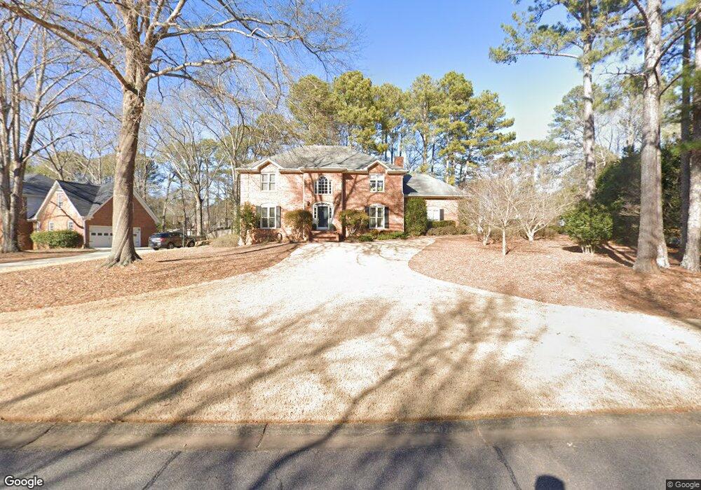
145 High Ridge Dr Athens, GA 30606
Estimated Value: $512,388 - $536,000
4
Beds
3
Baths
3,160
Sq Ft
$166/Sq Ft
Est. Value
About This Home
This home is located at 145 High Ridge Dr, Athens, GA 30606 and is currently estimated at $523,347, approximately $165 per square foot. 145 High Ridge Dr is a home located in Clarke County with nearby schools including Timothy Elementary School, Clarke Middle School, and Clarke Central High School.
Ownership History
Date
Name
Owned For
Owner Type
Purchase Details
Closed on
Mar 20, 2002
Sold by
English Brent A
Bought by
Tillman Joseph E
Current Estimated Value
Purchase Details
Closed on
Dec 5, 2001
Sold by
Smith Shelley
Bought by
English Brent A
Purchase Details
Closed on
May 26, 1999
Sold by
Robinson David J
Bought by
Smith Shelley
Purchase Details
Closed on
Jul 14, 1997
Sold by
Chortyk Orestes T and Chortyk Christine M
Bought by
Robinson David J
Purchase Details
Closed on
Apr 24, 1992
Sold by
Puri Jeewan L and Kum Kum
Bought by
Chortyk Orestes T and Chortyk Christine M
Create a Home Valuation Report for This Property
The Home Valuation Report is an in-depth analysis detailing your home's value as well as a comparison with similar homes in the area
Purchase History
| Date | Buyer | Sale Price | Title Company |
|---|---|---|---|
| Tillman Joseph E | $275,000 | -- | |
| English Brent A | $270,000 | -- | |
| Smith Shelley | $253,800 | -- | |
| Robinson David J | $219,500 | -- | |
| Chortyk Orestes T | $159,900 | -- |
Source: Public Records
Tax History
| Year | Tax Paid | Tax Assessment Tax Assessment Total Assessment is a certain percentage of the fair market value that is determined by local assessors to be the total taxable value of land and additions on the property. | Land | Improvement |
|---|---|---|---|---|
| 2025 | $5,832 | $206,702 | $20,000 | $186,702 |
| 2024 | $5,832 | $199,206 | $20,000 | $179,206 |
| 2023 | $5,726 | $191,600 | $20,000 | $171,600 |
| 2022 | $4,887 | $163,194 | $20,000 | $143,194 |
| 2021 | $4,432 | $141,524 | $20,000 | $121,524 |
| 2020 | $4,342 | $138,856 | $20,000 | $118,856 |
| 2019 | $4,276 | $135,956 | $20,000 | $115,956 |
| 2018 | $4,002 | $127,885 | $20,000 | $107,885 |
| 2017 | $3,760 | $120,747 | $20,000 | $100,747 |
| 2016 | $3,712 | $119,328 | $20,000 | $99,328 |
| 2015 | $3,711 | $119,133 | $20,000 | $99,133 |
| 2014 | $3,665 | $117,617 | $20,000 | $97,617 |
Source: Public Records
Map
Nearby Homes
- 134 Bent Tree Dr
- 125 Pine Tops Dr
- 184 Hillsborough Dr
- 128 Russell Way
- 164 Lucy Ln
- 118 Woodhaven Terrace
- 236 Melba Ln
- 400 Providence Rd
- 860 Mitchell Bridge Rd Unit 8
- 306 Providence Rd
- 575 Vaughn Rd
- 655 Rivermont Rd
- 175 New Haven Dr
- 150 The Preserve Dr Unit H2
- 145 Heyward Allen Pkwy
- 104 Westchester Cir Unit 4
- 105 Westchester Dr Unit G3
- 105 Westchester Dr Unit H10
- 105 Westchester Dr Unit E5
- 150 Creekwood Dr
- 124 Bent Tree Dr
- 140 High Ridge Dr
- 155 High Ridge Dr
- 123 Bent Tree Dr
- 150 High Ridge Dr
- 150 High Ridge Dr Unit 1
- 135 High Ridge Dr
- 130 High Ridge Dr
- 135 High Ridge Place
- 133 Bent Tree Dr
- 160 High Ridge Dr
- 144 Bent Tree Dr
- 120 High Ridge Dr
- 125 High Ridge Dr
- 143 Bent Tree Dr
- 155 High Ridge Place
- 175 High Ridge Dr
- 146 Woodhaven Cir
- 170 High Ridge Dr
- 136 Woodhaven Cir
Your Personal Tour Guide
Ask me questions while you tour the home.